The name Yarraman means horse in the Port Jackson Pidgin English spread by Aboriginal stockmen in eastern Australia. It might derive from word yira or yera meaning large teeth.[2]
The creek at Yarraman was used in the 1870s as a place for local graziers and stockmen to meet and trade cattle. The township was established in the late 1870s.[5]
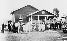
Crowd in front of Yarraman State School, circa 1913
Yarraman Creek Provisional School opened on 17 July 1901 with 10 students, some miles east of the current school site. On 1 January 1909, it became Yarraman Creek State School. On 31 August 1914, a new school site was established with a new school building.[6] In 1935, it was renamed Yarraman State School. In 1963, the school expanded to include a secondary department with an initial enrolment of 47 students. In 1980, a pre-school was added.[7][8]
As there were many large hoop pine forests in the area, a timber mill was established in 1910.[5]
Opening of the Country Women's Association Hall, Yarraman, 1928
The Queensland Country Women's Association established a branch at Yarraman in 1923.[10] After raising funds a new QCWA Hall was opened in 1928.[11] After both Blackbutt and Yarraman branches had been closed for a number of years, the Blackbutt and Yarraman QCWA branch was formed after their first meeting in 2014. The Yarraman QCWA building had already been removed and sold.[12]
Rocky Hill Provisional School opened on 30 October 1924. A new school building was erected and in October 1929 it became Rocky Hill State School.[13] It closed in 1963.[8][14] The building was relocated to Yarraman in the 1960s and has been used for various community purposes. In 2016 it was relocated to the Yarraman Heritage House where it will be restored as classrooms with school displays.[15]
During World War II, Yarraman was the location of RAAF No.21 Inland Aircraft Fuel Depot (IAFD), completed in 1942 and closed on 29 August 1944. Usually consisting of 4 tanks, 31 fuel depots were built across Australia for the storage and supply of aircraft fuel for the RAAF and the US Army Air Forces at a total cost of £900,000 ($1,800,000).[16]
The Sacred Heart Convent was completed in 1945. The Sisters of Mercy opened a boarding school for boys in 1946. It closed in 1966. The building is now used as the Yarraman Heritage House.[17]
The Yarraman Library opened in 1982 and had a major refurbishment in 2016.[18] it is now operated by the Toowoomba Regional Council.[19]
Between 2002 and 2018, the former Brisbane Valley railway line was redeveloped as the Brisbane Valley Rail Trail, the longest rail trail in Australia at 161 kilometres (100mi).[20]
Demographics
Based on data gathered through the census, Yarraman's population has grown as shown below.
The Yarraman Library and Post Office are located on the corner of Toomey and Douglas Streets, and offer access to wireless internet.[30][31] The Toowoomba Regional Council refurbished the library in 2016 including new furnishings, paint, and an accessible parking space and toilet.[32]
Blackbutt-Yarraman Queensland Country Women's Association Hall, 2023
The Blackbutt Yarraman branch of the Queensland Country Women's Association meets at the QCWA Hall at 65 Coulson Street in Blackbutt.[34]
Yarraman has a not-for-profit community radio station Wild Horse FM 99.7 which began broadcasting in 2002. The station is housed in the Historic Yarraman Heritage House.[35]
Yarraman has three churches: St Philip's Anglican Church, Our Lady of Dolours Catholic Church, and Calvary Lutheran church.
↑ "New School at Yarraman". Queensland Times. Vol.LVI, no.9117. Queensland, Australia. 30 September 1914. p.4 (Daily). Retrieved 13 October 2024– via National Library of Australia.
↑ "Our school". Yarraman State School. 18 February 2020. Archived from the original on 10 November 2023. Retrieved 10 November 2023.
↑ "C.V.A."The Brisbane Courier. No.23, 422. Queensland, Australia. 23 February 1933. p.17. Archived from the original on 26 July 2023. Retrieved 19 January 2023– via National Library of Australia.
↑ McGrath, Jessica (30 October 2023). "QCWA returns 'home'". Burnett Today. Archived from the original on 19 January 2023. Retrieved 19 January 2023.
↑ "To Cost £70,000". The Telegraph. No.17, 588. Queensland, Australia. 18 April 1929. p.5. Archived from the original on 14 July 2022. Retrieved 28 November 2019.
This page is based on this Wikipedia article Text is available under the CC BY-SA 4.0 license; additional terms may apply. Images, videos and audio are available under their respective licenses.


