
Toowoomba is a city in the Toowoomba Region of the Darling Downs, Queensland, Australia. It is 125 km (78 mi) west of Queensland's capital city Brisbane by road. The urban population of Toowoomba as of the 2021 census was 142,163, having grown at an average annual rate of 1.45% over the previous two decades. Toowoomba is the second-most-populous inland city in the country after the nation's capital of Canberra, and hence the largest city on the Darling Downs. It is the third largest regional centre in Queensland, often referred to as the capital of the Darling Downs.

The Darling Downs is a farming region on the western slopes of the Great Dividing Range in southern Queensland, Australia. The Downs are to the west of South East Queensland and are one of the major regions of Queensland. The name was generally applied to an area approximating to that of the Condamine River catchment upstream of Condamine township but is now applied to a wider region comprising the Southern Downs, Western Downs, Toowoomba and Goondiwindi local authority areas. The name Darling Downs was given in 1827 by Allan Cunningham, the first European explorer to reach the area and recognises the then Governor of New South Wales, Ralph Darling.

Yarraman is a rural town and locality in the Toowoomba Region, Queensland, Australia. In the 2021 census, the locality of Yarraman had a population of 1,127 people.

Drayton is a rural locality in the Toowoomba Region, Queensland, Australia. In the 2016 census, Drayton had a population of 1,710 people.

Pittsworth is a rural town and locality in the Toowoomba Region, Queensland, Australia. In the 2016 census, the locality of Pittsworth had a population of 3,294 people.

Highfields is a town and locality in the Toowoomba Region, Queensland, Australia. In 2017, it was the fastest growing area in Toowoomba. At 30 June 2019, the estimated resident population for the Highfields was 14,298.

Cambooya is a rural town and locality in the Toowoomba Region, Queensland, Australia. In the 2016 census the locality of Cambooya had a population of 1,584 people.

Crows Nest is a rural town and locality in the Toowoomba Region, Queensland, Australia. The town is located in the Darling Downs on the New England Highway, 158 kilometres (98 mi) from the state capital, Brisbane and 43 kilometres (27 mi) from the nearby city of Toowoomba. In the 2016 census, Crows Nest had a population of 2160 people.

Leyburn is a rural town in the Southern Downs Region and a locality split between the South Downs Region and the Toowoomba Region in Queensland, Australia. In the 2016 census, Leyburn had a population of 476 people.

Kingsthorpe is a rural town and locality in the Toowoomba Region, Queensland, Australia. In the 2021 census, the locality of Kingsthorpe had a population of 2,159 people.
James Purcell was an Australian businessman of the early 20th century, mainly active in the dairy industry on the Darling Downs in Queensland.

Harlaxton is a locality in the Toowoomba Region, Queensland, Australia. In the 2016 census, Harlaxton had a population of 2,547 people. Traditionally a rural area, most of the locality is now residential.
North Toowoomba is a suburban locality in Toowoomba in the Toowoomba Region, Queensland, Australia. In the 2021 census, North Toowoomba had a population of 3,332 people.
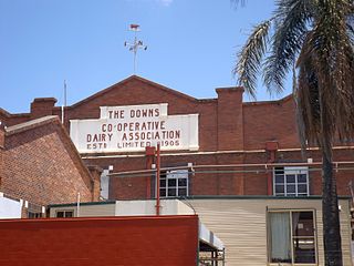
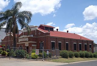
The Downs Co-operative Dairy Association Limited Factory is a heritage-listed factory at 57 Brook Street, North Toowoomba, Toowoomba, Toowoomba Region, Queensland, Australia. It is also known as Dairy Farmers Factory. It was added to the Queensland Heritage Register on 18 April 2008.

Boodua is a rural locality in the Toowoomba Region, Queensland, Australia. In the 2016 census Boodua had a population of 93 people.

Meringandan West is a rural locality in the Toowoomba Region, Queensland, Australia. In the 2016 census, Meringandan West had a population of 2211 people.
Captains Mountain is a locality in the Toowoomba Region, Queensland, Australia. In the 2021 census, Captains Mountain had a population of 74 people.
James Henry Cecil Roberts was a member of the Queensland Legislative Assembly.
The Boonah Butter Factory is a heritage-listed former butter factory in Boonah, Scenic Rim Region, Queensland, Australia. Constructed in 1916, it is a prominent landmark at the intersection of Boonah-Rathdowney Road and Railway Street on the northern entry to Boonah. During the first part of the twentieth century, it was one of the most modern butter factories in the Commonwealth, the largest butter factory in the Southern Hemisphere, had the second highest output of butter in Queensland and was a major supplier of dairy products to Brisbane. The former Boonah Butter Factory office, which is currently the premises of Flavours Cafe, is on the Local Heritage Register of the Scenic Rim Regional Council in acknowledgement of the site's historic, aesthetic and cultural significance.

