Googa Creek

Last updated

Googa Creek
Queensland
Australia Queensland location map.svg
Red pog.svg
Googa Creek
Coordinates 26°57′48″S152°03′19″E / 26.9633°S 152.0552°E / -26.9633; 152.0552 (Googa Creek (centre of locality))
Population43 (2016 census) [1]
 • Density0.587/km2 (1.521/sq mi)
Postcode(s) 4314
Area73.2 km2 (28.3 sq mi)
Time zone AEST (UTC+10:00)
Location
LGA(s) Toowoomba Region
State electorate(s) Nanango
Federal division(s) Maranoa
Suburbs around Googa Creek:
Gilla Blackbutt South Cherry Creek
Mount Binga Googa Creek Anduramba
Emu Creek Emu Creek Anduramba

Googa Creek is a rural locality in the Toowoomba Region, Queensland, Australia. [2] In the 2016 census Googa Creek had a population of 43 people. [1]

Contents

History

Googa Googa Creek State School opened on 9 May 1921 and closed on 1950. [3] It was located at approximately 26°57′18″S152°02′35″E / 26.9550°S 152.0430°E / -26.9550; 152.0430 (Googa Googa Creek State School) to the west of Googa Googa Creek within the present-day Googa State Forest. [4] [5]

A telephone service for Googa Creek was approved in 1947. [6]

In the 2016 census Googa Creek had a population of 43 people. [1]

On 1 February 2018, Googa Creek's postcode changed from 4306 to 4314. [7]

Education

There are no school in Googa Creek. The nearest primary school is Blackbutt State School in Blackbutt to the north-east. The nearest secondary schools are Yarraman State School (to Year 9) in Yarraman to the north-west and Nanango State High School (to Year 12) in Nanango to the north. [5]

Related Research Articles

<span class="mw-page-title-main">Yarraman, Queensland</span> Town in Queensland, Australia

Yarraman is a rural town and locality in the Toowoomba Region, Queensland, Australia. In the 2021 census, the locality of Yarraman had a population of 1,127 people.

<span class="mw-page-title-main">Nanango</span> Town in Queensland, Australia

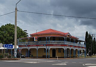
Nanango is a rural town and locality in the South Burnett Region, Queensland, Australia. In the 2021 census, the locality of Nanango had a population of 3,679 people.

<span class="mw-page-title-main">D'Aguilar Highway</span> Highway in Queensland, Australia

The D'Aguilar Highway is a two-lane highway linking the Bruce Highway near Caboolture with Kingaroy in the state of Queensland, Australia. Major towns along the route include Woodford, Kilcoy, Blackbutt, Yarraman, Nanango and Kingaroy. The highway is approximately 164 km (102 mi) in length. The D'Aguilar Highway's highest elevation along its length is 527 m just north of Yarraman, and the lowest point is at 26.8m just west of Caboolture.

<span class="mw-page-title-main">Blackbutt, Queensland</span> Town in Queensland, Australia

Blackbutt is a rural town and locality in the South Burnett Region, Queensland, Australia. In the 2016 census, Blackbutt had a population of 836 people.

<span class="mw-page-title-main">Moore, Queensland</span> Town in Queensland, Australia

Moore is a rural town and locality in the Somerset Region, Queensland, Australia. In the 2016 census, the locality of Moore had a population of 296 people.

<span class="mw-page-title-main">Harlin</span> Town in Queensland, Australia

Harlin is a rural town and locality in the Somerset Region, Queensland, Australia. In the 2016 census, the locality of Harlin had a population of 173 people.

<span class="mw-page-title-main">Benarkin</span> Town in Queensland, Australia

Benarkin is a rural town and locality in the South Burnett Region, Queensland, Australia. The nearby town of Blackbutt is the origin of the town and the two towns are often referred to as the joint entity Blackbutt-Benarkin. In the 2016 census, Benarkin had a population of 61 people.

<span class="mw-page-title-main">Colinton, Queensland</span> Suburb of Somerset Region, Queensland, Australia

Colinton is a rural locality in the Somerset Region, Queensland, Australia. In the 2016 census, Colinton had a population of 75 people.

<span class="mw-page-title-main">Upper Yarraman, Queensland</span> Suburb of Toowoomba Region, Queensland, Australia

Upper Yarraman is a rural locality in the Toowoomba Region, Queensland, Australia. In the 2016 census, Upper Yarraman had a population of 104 people.

<span class="mw-page-title-main">Spring Creek, Queensland (Darling Downs)</span> Suburb of Toowoomba Region, Queensland, Australia

Spring Creek is a rural locality split between the Toowoomba Region and the Southern Downs Region, Queensland, Australia. In the 2016 census, Spring Creek had a population of 194 people.

Pimpimbudgee is a rural locality in the South Burnett Region, Queensland, Australia. In the 2016 census Pimpimbudgee had a population of 72 people.

Nukku is a rural locality in the South Burnett Region, Queensland, Australia. In the 2016 census Nukku had a population of 22 people.

Cherry Creek is a rural locality in the Toowoomba Region, Queensland, Australia. In the 2016 census Cherry Creek had a population of 49 people.

Mount Stanley is a rural locality in the Somerset Region, Queensland, Australia. In the 2016 census Mount Stanley had a population of 7 people.

Mount Binga is a rural locality in the Toowoomba Region, Queensland, Australia. In the 2016 census Mount Binga had a population of 67 people.

Gilla is a rural locality in the Toowoomba Region, Queensland, Australia. In the 2016 census Gilla had a population of 32 people.

<span class="mw-page-title-main">Douglas, Queensland (Toowoomba Region)</span> Suburb of Toowoomba Region, Queensland, Australia

Douglas is a rural locality in the Toowoomba Region, Queensland, Australia. In the 2016 census, Douglas had a population of 112 people.

Eskdale is a rural locality in the Somerset Region, Queensland, Australia. In the 2021 census, Eskdale had a population of 34 people.

East Cooyar is a rural locality in the Toowoomba Region, Queensland, Australia. In the 2021 census, East Cooyar had a population of 27 people.

Emu Creek is a rural locality in the Toowoomba Region, Queensland, Australia. In the 2021 census, Emu Creek had a population of 113 people.

References

  1. 1 2 3 Australian Bureau of Statistics (27 June 2017). "Googa Creek (SSC)". 2016 Census QuickStats. Retrieved 20 October 2018. OOjs UI icon edit-ltr-progressive.svg
  2. "Googa Creek – locality in Toowoomba Region (entry 49224)". Queensland Place Names. Queensland Government . Retrieved 29 December 2020.
  3. Queensland Family History Society (2010), Queensland schools past and present (Version 1.01 ed.), Queensland Family History Society, ISBN   978-1-921171-26-0
  4. "Parish of Emu Creek" (Map). Queensland Government. 1942. Retrieved 20 July 2021.
  5. 1 2 "Queensland Globe". State of Queensland . Retrieved 20 July 2021.
  6. "TELEPHONE FOR GOOGA CREEK". Queensland Times . No. 18, 889. Queensland, Australia. 20 June 1947. p. 2 (DAILY). Retrieved 20 July 2021 via National Library of Australia.
  7. "Blackbutt To Get New Postcode". southburnett.com.au. 17 November 2017. Archived from the original on 17 May 2018. Retrieved 5 July 2021.