Kings Creek, Queensland

Last updated

Kings Creek
Queensland
Australia Queensland location map.svg
Red pog.svg
Kings Creek
Coordinates 27°52′55″S151°55′04″E / 27.8819°S 151.9177°E / -27.8819; 151.9177 (Kings Creek (centre of locality))
Population55 (2021 census) [1]
 • Density1.567/km2 (4.06/sq mi)
Postcode(s) 4361
Elevation430–470 m (1,411–1,542 ft) [2]
Area35.1 km2 (13.6 sq mi)
Time zone AEST (UTC+10:00)
Location
LGA(s) Toowoomba Region
State electorate(s) Condamine
Federal division(s) Maranoa
Suburbs around Kings Creek:
Nobby Nobby Nevilton
Mount Molar Kings Creek Missen Flat
Ryeford Clifton Clifton

Kings Creek is a rural locality in the Toowoomba Region, Queensland, Australia. [3] In the 2021 census, Kings Creek had a population of 55 people. [1]

Contents

Geography

The creek Kings Creek enters the locality from the north-east (Nobby / Nevilton) and flows south-west across the locality, exiting to the south-west (Ryeford / Clifton); it is a tributary of the Condamine River. [2]

The Felton Clifton Road enters locality from the north (Nobby) and exits to the south (Clifton). [2] The South Western railway line runs immediately east and parallel to the road. [2] The district was once served by the now-closed Kings Creek railway station which was immediately north of the crossing of the line over the creek ( 27°54′02″S151°54′30″E / 27.90045°S 151.90824°E / -27.90045; 151.90824 (Kings Creek railway station (former)) ). [4]

The land is relatively flat and the land use is predominantly crop growing with some grazing on native vegetation. [2]

History

The locality takes its name from the creek, which was named after pastoralist Joseph King of the Pilton and Clifton pastoral runs during the 1840s. [3]

In September 1883, tenders are called for the erection of a provisional school in King's Creek. [5] King's Creek Provisional School opened on 4 February 1884. [6] In November 1900, it became King's Creek State School. It closed on 30 April 1931. [7] It was on the eastern side of the road and railway (approx 27°53′27″S151°54′30″E / 27.89070°S 151.90825°E / -27.89070; 151.90825 (King's Creek State School (former)) ). [8]

An undated map shows allotments for sale in the township of King's Creek ( 27°53′31″S151°54′43″E / 27.892°S 151.912°E / -27.892; 151.912 (Kings Creek (proposed township)) ), situated on the "Clifton Estate". The allotments were adjacent to the South-Western railway line, close to King's Creek railway station, and the watercourse King's Creek. [9] [10] In June 1885, all of the allotments at the new township of King's Creek were sold but there was limited interest in the farm sites outside the town as the prices were thought to be too high. [11] The township failed to develop; that land is now used for farming. [2]

In December 1906, a Methodist church was opened at Kings Creek. [12] [13]

Kings Creek has a history of fossil finds over the years. In 1936, a prehistoric jaw bone was found. [14] In 2013, a late Pleistocene tooth was found in 2013 and attributed to Quinkana (an extinct species of crocodile). It was most similar to fragmentary teeth from Quinkana foritrostrum , but was not attributed to any species because of a lack of complete specimens. [15]

Demographics

In the 2016 census, Kings Creek had a population of 72 people. [16]

In the 2021 census, Kings Creek had a population of 55 people. [1]

Education

There are no schools in Kings Creek. The nearest government primary schools are Nobby State School in neighbouring Nobby to the north and Clifton State School in neighbouring Clifton to the south. The nearest government secondary school is Clifton State High School, also in Clifton. [17]

Related Research Articles

<span class="mw-page-title-main">Nobby, Queensland</span> Town in Queensland, Australia

Nobby is a rural town and locality on the Darling Downs in the Toowoomba Region, Queensland, Australia. It is located halfway between Toowoomba and Warwick. It is known for its association with Steele Rudd (author) and Sister Elizabeth Kenny.

<span class="mw-page-title-main">Clifton, Queensland</span> Town in Queensland, Australia

Clifton is a rural town and locality in the Toowoomba Region, Queensland, Australia. In the 2016 census, Clifton had a population of 1,456 people.

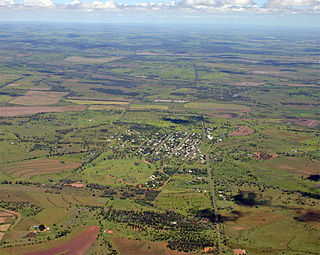
Gowrie Junction is a rural locality in the Toowoomba Region, Queensland, Australia. It is north-west of Toowoomba. In the 2021 census, Gowrie Junction had a population of 2,030 people. The town of Gowrie is in the eastern part of the locality.

<span class="mw-page-title-main">Allora, Queensland</span> Town in Queensland, Australia

Allora is a rural town and locality in the Southern Downs Region, Queensland, Australia. In the 2016 census, the locality of Allora had a population of 1,223 people.

<span class="mw-page-title-main">Greenmount, Queensland (Toowoomba Region)</span> Town in Queensland, Australia

Greenmount is a rural town and locality in the Toowoomba Region, Queensland, Australia. In the 2016 census, the locality of Greenmount had a population of 699 people.

<span class="mw-page-title-main">Bell, Queensland</span> Town in Queensland, Australia

Bell is a rural town and locality in the Western Downs Region, Queensland, Australia. In the 2016 census, the locality of Bell had a population of 502 people.

<span class="mw-page-title-main">Cambooya, Queensland</span> Town in Queensland, Australia

Cambooya is a rural town and locality in the Toowoomba Region, Queensland, Australia. In the 2016 census the locality of Cambooya had a population of 1,584 people.

<span class="mw-page-title-main">Kingsthorpe, Queensland</span> Town in Queensland, Australia

Kingsthorpe is a rural town and locality in the Toowoomba Region, Queensland, Australia. In the 2021 census, the locality of Kingsthorpe had a population of 2,159 people.

<span class="mw-page-title-main">Karara, Queensland</span> Town in Queensland, Australia

Karara is a rural town and locality in the Southern Downs Region, Queensland, Australia. In the 2016 census, the locality of Karara had a population of 123 people.

<span class="mw-page-title-main">Ballard, Queensland</span> Suburb of Lockyer Valley Region, Queensland, Australia

Ballard is a rural locality in the Lockyer Valley Region, Queensland, Australia. In the 2021 census, Ballard had a population of 167 people.

<span class="mw-page-title-main">Yangan, Queensland</span> Town in Queensland, Australia

Yangan is a rural town and locality in the Southern Downs Region, Queensland, Australia. In the 2021 census, the locality of Yangan had a population of 404 people.

<span class="mw-page-title-main">Geham</span> Suburb of Toowoomba Region, Queensland, Australia

Geham is a rural locality in the Toowoomba Region, Queensland, Australia. In the 2021 census, Geham had a population of 470 people.

<span class="mw-page-title-main">Allan, Queensland</span> Suburb of Southern Downs Region, Queensland, Australia

Allan is a rural locality in the Southern Downs Region, Queensland, Australia. It was formerly known as Sandy Creek. In the 2021 census, Allan had a population of 91 people.

<span class="mw-page-title-main">East Greenmount, Queensland</span> Suburb of Toowoomba Region, Queensland, Australia

East Greenmount is a rural town and locality in the Toowoomba Region, Queensland, Australia. In the 2021 census, the locality of East Greenmount had a population of 351 people.

<span class="mw-page-title-main">Ascot, Queensland (Toowoomba Region)</span> Suburb of Toowoomba Region, Queensland, Australia

Ascot is a rural locality in the Toowoomba Region, Queensland, Australia. In the 2021 census, Ascot had a population of 106 people.

<span class="mw-page-title-main">Felton, Queensland</span> Suburb of Toowoomba Region, Queensland, Australia

Felton is a rural locality in the Toowoomba Region, Queensland, Australia. In the 2021 census, Felton had a population of 267 people.

<span class="mw-page-title-main">Boodua, Queensland</span> Suburb of Toowoomba Region, Queensland, Australia

Boodua is a rural locality in the Toowoomba Region, Queensland, Australia. In the 2021 census, Boodua had a population of 95 people.

Goomburra is a rural town and locality in the Southern Downs Region, Queensland, Australia. In the 2016 census, the locality of Goomburra had a population of 259 people.

Irvingdale is a locality split between the Toowoomba Region and the Western Downs Region, both in Queensland, Australia. In the 2021 census, Irvingdale had a population of 163 people.

Narko is a rural locality in the Toowoomba Region, Queensland, Australia. In the 2021 census, Narko had a population of 16 people.

References

  1. 1 2 3 Australian Bureau of Statistics (28 June 2022). "Kings Creek (SAL)". 2021 Census QuickStats. Retrieved 28 February 2023. OOjs UI icon edit-ltr-progressive.svg
  2. 1 2 3 4 5 6 "Queensland Globe". State of Queensland . Retrieved 2 October 2023.
  3. 1 2 "Kings Creek – locality in Toowoomba Region (entry 49269)". Queensland Place Names. Queensland Government . Retrieved 11 June 2019.
  4. "Clifton" (Map). Queensland Government. 1944. Archived from the original on 6 September 2023. Retrieved 3 October 2023.
  5. "Advertising". Warwick Examiner and Times . Vol. XVII, no. 998. Queensland, Australia. 19 September 1883. p. 3. Archived from the original on 2 October 2023. Retrieved 3 October 2023 via National Library of Australia.
  6. "GREENMOUNT". Darling Downs Gazette . Vol. XXIII, no. 5, 603. Queensland, Australia. 4 February 1884. p. 3. Archived from the original on 2 October 2023. Retrieved 3 October 2023 via National Library of Australia.
  7. Queensland Family History Society (2010), Queensland schools past and present (Version 1.01 ed.), Queensland Family History Society, ISBN   978-1-921171-26-0
  8. "Parish of Tooth" (Map). Queensland Government. 1933. Retrieved 3 October 2023.
  9. "Township of King's Creek: situated on the Clifton Estate, Darling Downs (c. 1880–1910)" (Map). Subdivision Map. n.d. hdl:10462/deriv/483715.
  10. "Parish of Clifton and Tabletop" (Map). Queensland Government. 1942. Archived from the original on 2 October 2023. Retrieved 3 October 2023.
  11. "Clifton Estate Sale". Darling Downs Gazette . Vol. XXIV, no. 5,791. Queensland, Australia. 20 June 1885. p. 3. Archived from the original on 15 September 2020. Retrieved 26 November 2019 via National Library of Australia.
  12. "RELIGIOUS". The Brisbane Courier . Vol. LXIII, no. 15, 260. Queensland, Australia. 8 December 1906. p. 16. Archived from the original on 2 October 2023. Retrieved 2 October 2023 via National Library of Australia.
  13. "METHODISM". Warwick Daily News . No. 5109. Queensland, Australia. 30 November 1935. p. 8. Archived from the original on 11 September 2021. Retrieved 10 September 2021 via National Library of Australia.
  14. "WHAT IS IT". The Queenslander . No. 2871. Queensland, Australia. 10 September 1921. p. 36. Archived from the original on 2 October 2023. Retrieved 3 October 2023 via National Library of Australia.
  15. Sobbe, Ian H.; Price, Gilbert J.; Knezour, Robert A. (2013). "A ziphodont crocodile from the late Pleistocene King Creek catchment, Darling Downs, Queensland". Memoirs of the Queensland Museum . 52 (2): 601–606.
  16. Australian Bureau of Statistics (27 June 2017). "Kings Creek (SSC)". 2016 Census QuickStats. Retrieved 20 October 2018. OOjs UI icon edit-ltr-progressive.svg
  17. "Layers: Locality; Schools and school catchments". Queensland Globe. Queensland Government. Archived from the original on 19 December 2017. Retrieved 2 October 2023.

Further reading