Springside, Queensland

Last updated

Springside
Queensland
Australia Queensland location map.svg
Red pog.svg
Springside
Coordinates 27°40′24″S151°34′49″E / 27.6733°S 151.5802°E / -27.6733; 151.5802 (Springside (centre of locality))
Population102 (SAL 2021) [1]
Postcode(s) 4356
Area31.7 km2 (12.2 sq mi)
Time zone AEST (UTC+10:00)
Location
LGA(s) Toowoomba Region
State electorate(s) Condamine
Federal division(s) Groom
Suburbs around Springside:
Irongate Rossvale Rossvale
Irongate Springside Stoneleigh
St Helens Yarranlea Pittsworth

Springside is a rural locality in the Toowoomba Region, Queensland, Australia. [2] In the 2021 census, Springside had a population of 102 people. [3]

Contents

History

The first school in Springside was a private school built from slabs on the property of Tom Honor, which was later replaced by larger slab building. Springside Provisional School was built by local parents about one mile south of the earlier school and was opened on 6 February 1888. It became Springside State School in 1897. [4] The school celebrated its diamond jubilee (60th anniversary) on 3 September 1948. [5] It closed on 30 May 1954. [6] [7] It was at 28 Tews Road ( 27°40′06″S151°35′19″E / 27.66823°S 151.58860°E / -27.66823; 151.58860 (Springside State School (former)) ). [8] [9] [10]

St John's Anglican Church was dedicated in 1898 and closed circa 1974. [11] It was at 3237 Oakey Pittsworth Road ( 27°40′07″S151°35′30″E / 27.66860°S 151.59179°E / -27.66860; 151.59179 (St John's Anglican Church (former)) ). [12] [10] After closure, the church building was relocated to the site of St Philip's at Mount Tyson for use as a Sunday school and later remodelled as a parish hall. [11] It is now privately owned. [13]

Demographics

In the 2016 census, Springside had a population of 108 people. [14]

In the 2021 census, Springside had a population of 102 people. [3]

Education

There are no schools in Springside, but primary and secondary schools are available in neighbouring Pittsworth. [10]

Related Research Articles

<span class="mw-page-title-main">Pittsworth, Queensland</span> Town in Queensland, Australia

Pittsworth is a rural town and locality in the Toowoomba Region, Queensland, Australia. In the 2016 census, the locality of Pittsworth had a population of 3,294 people.

<span class="mw-page-title-main">Millmerran, Queensland</span> Town in Queensland, Australia

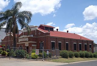
Millmerran, known as Domville between 1 June 1889 and 16 November 1894, is a town and a locality in the Toowoomba Region, Queensland, Australia. In the 2016 census, the locality of Millmerran had a population of 1,563 people.

<span class="mw-page-title-main">Leyburn, Queensland</span> Town in Queensland, Australia

Leyburn is a rural town in the Southern Downs Region and a locality split between the South Downs Region and the Toowoomba Region in Queensland, Australia. In the 2016 census, Leyburn had a population of 476 people.

<span class="mw-page-title-main">North Toowoomba, Queensland</span> Suburb of Toowoomba, Queensland, Australia

North Toowoomba is a suburban locality in Toowoomba in the Toowoomba Region, Queensland, Australia. In the 2021 census, North Toowoomba had a population of 3,332 people.

<span class="mw-page-title-main">Mount Tyson, Queensland</span> Town in Queensland, Australia

Mount Tyson is a rural town and locality in the Toowoomba Region, Queensland, Australia. In the 2016 census, the locality of Mount Tyson had a population of 285 people.

<span class="mw-page-title-main">Aubigny, Queensland</span> Town in Queensland, Australia

Aubigny is a rural town and locality in the Toowoomba Region, Queensland, Australia. In the 2016 census, the locality of Aubigny had a population of 254 people.

<span class="mw-page-title-main">Southbrook, Queensland</span> Town in Queensland, Australia

Southbrook is a rural town and locality in the Toowoomba Region, Queensland, Australia. In the 2021 census, the locality of Southbrook had a population of 626 people.

<span class="mw-page-title-main">Felton, Queensland</span> Suburb of Toowoomba Region, Queensland, Australia

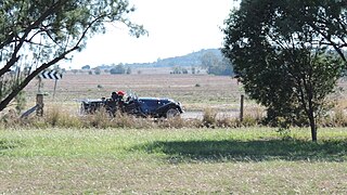
Felton is a rural locality in the Toowoomba Region, Queensland, Australia. In the 2016 census, Felton had a population of 276 people.

<span class="mw-page-title-main">Linthorpe, Queensland</span> Suburb of Toowoomba Region, Queensland, Australia

Linthorpe is a rural locality in the Toowoomba Region, Queensland, Australia. In the 2021 census, Linthorpe had a population of 416 people.

Clontarf is a rural locality in the Toowoomba Region, Queensland, Australia. In the 2021 census, Clontarf had a population of 28 people.

<span class="mw-page-title-main">Spring Creek, Queensland (Darling Downs)</span> Suburb of Toowoomba Region, Queensland, Australia

Spring Creek is a rural locality split between the Toowoomba Region and the Southern Downs Region, Queensland, Australia. In the 2016 census, Spring Creek had a population of 194 people.

Ellangowan is a rural locality in the Toowoomba Region, Queensland, Australia. In the 2021 census, Ellangowan had a population of 95 people.

<span class="mw-page-title-main">Brookstead, Queensland</span> Town in Queensland, Australia

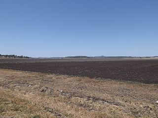
Brookstead is a rural town and locality in the Toowoomba Region, Queensland, Australia. In the 2016 census, Brookstead had a population of 217 people.

Irongate is a rural locality in the Toowoomba Region, Queensland, Australia. In the 2021 census, Irongate had a population of 135 people.

<span class="mw-page-title-main">North Branch, Queensland (Toowoomba Region)</span> Suburb of Toowoomba Region, Queensland, Australia

North Branch is a locality in the Toowoomba Region, Queensland, Australia. In the 2021 census, North Branch had a population of 48 people.

Rossvale is a rural locality in the Toowoomba Region, Queensland, Australia. In the 2016 census, Rossvale had a population of 75 people.

<span class="mw-page-title-main">Tummaville, Queensland</span> Suburb of Toowoomba Region, Queensland, Australia

Tummaville is a rural locality in the Toowoomba Region, Queensland, Australia. In the 2016 census, Tummaville had a population of 63 people.

Yarranlea is a rural locality in the Toowoomba Region, Queensland, Australia. In the 2016 census, Yarranlea had a population of 90 people.

Stoneleigh is a locality in the Toowoomba Region, Queensland, Australia. In the 2021 census, Stoneleigh had a population of 124 people.

Turallin is a rural town and locality in the Toowoomba Region, Queensland, Australia. In the 2021 census, the locality of Turallin had a population of 64 people.

References

  1. Australian Bureau of Statistics (28 June 2022). "Springside (Qld) (suburb and locality)". Australian Census 2021 QuickStats. Retrieved 28 June 2022.  OOjs UI icon edit-ltr-progressive.svg
  2. "Springside – locality in Toowoomba Region (entry 48065)". Queensland Place Names. Queensland Government . Retrieved 12 April 2019.
  3. 1 2 Australian Bureau of Statistics (28 June 2022). "Springside (SAL)". 2021 Census QuickStats. Retrieved 28 February 2023. OOjs UI icon edit-ltr-progressive.svg
  4. "Education Department". The Week . Vol. XLIII, no. 1, 101. Queensland, Australia. 29 January 1897. p. 21. Retrieved 12 January 2024 via National Library of Australia.
  5. "DIAMOND JUBILEE OF SPRINGSIDE STATE SCHOOL". Pittsworth Sentinel . Vol. 48. Queensland, Australia. 24 August 1948. p. 2. Retrieved 12 January 2024 via National Library of Australia.
  6. "Agency ID 9223, Springside State School". Queensland State Archives . Retrieved 12 January 2024.
  7. Queensland Family History Society (2010), Queensland schools past and present (Version 1.01 ed.), Queensland Family History Society, ISBN   978-1-921171-26-0
  8. "Parish of Beauaraba" (Map). Queensland Government. 1932. Archived from the original on 15 January 2024. Retrieved 12 January 2024.
  9. "Toowoomba" (Map). Queensland Government. 1954. Archived from the original on 12 January 2024. Retrieved 12 January 2024.
  10. 1 2 3 "Queensland Globe". State of Queensland . Retrieved 16 January 2024.
  11. 1 2 "Anglican Records and Archives Centre - Closed Churches". Archived from the original on 3 April 2019. Retrieved 3 April 2019.
  12. "Parish of Beauraba" (Map). Queensland Government. 1932. Archived from the original on 15 January 2024. Retrieved 16 January 2024.
  13. "Australia's Christian Heritage: St Philip's Anglican Church - Former". 8 October 2013. Archived from the original on 3 April 2019. Retrieved 3 April 2019.
  14. Australian Bureau of Statistics (27 June 2017). "Springside (SSC)". 2016 Census QuickStats. Retrieved 20 October 2018. OOjs UI icon edit-ltr-progressive.svg