Inglewood is a rural town and locality in the Goondiwindi Region, Queensland, Australia. In the 2021 census, the locality of Inglewood had a population of 936 people.

Yelarbon is a rural town and locality in the Goondiwindi Region, Queensland, Australia. It is on the border of Queensland and New South Wales. In the 2021 census, the locality of Yelarbon had a population of 313 people.

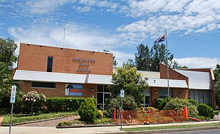
Millmerran, known as Domville between 1 June 1889 and 16 November 1894, is a town and a locality in the Toowoomba Region, Queensland, Australia. In the 2021 census, the locality of Millmerran had a population of 1,545 people.
Wyreema is a rural town and locality in the Toowoomba Region, Queensland, Australia. In the 2021 census, the locality of Wyreema had a population of 2,076 people.

Karara is a rural town and locality in the Southern Downs Region, Queensland, Australia. In the 2021 census, the locality of Karara had a population of 128 people.
Lemontree is a rural locality in the Toowoomba Region, Queensland, Australia. In the 2021 census, Lemontree had a population of 27 people.
Yandilla is a rural locality in the Toowoomba Region, Queensland, Australia. In the 2021 census, Yandilla had a population of 50 people.
Captains Mountain is a locality in the Toowoomba Region, Queensland, Australia. In the 2021 census, Captains Mountain had a population of 74 people.

Domville is a rural locality in the Toowoomba Region, Queensland, Australia. In the 2021 census, Domville had "no people or a very low population".
Clontarf is a rural locality in the Toowoomba Region, Queensland, Australia. In the 2021 census, Clontarf had a population of 28 people.
Ellangowan is a rural locality in the Toowoomba Region, Queensland, Australia. In the 2021 census, Ellangowan had a population of 95 people.
Canning Creek is a rural locality split between the Goondiwindi Region and the Toowoomba Region in Queensland, Australia. In the 2021 census, Canning Creek had a population of 21 people.
Bringalily is a rural locality in the Toowoomba Region, Queensland, Australia. In the 2021 census, Bringalily had a population of 64 people.
Kooroongarra is a rural town and locality in the Toowoomba Region, Queensland, Australia. In the 2021 census, the locality of Kooroongarra had a population of 45 people.

Tummaville is a rural locality in the Toowoomba Region, Queensland, Australia. In the 2021 census, Tummaville had a population of 55 people.
Turallin is a rural town and locality in the Toowoomba Region, Queensland, Australia. In the 2021 census, the locality of Turallin had a population of 64 people.
Millmerran Woods is a rural locality in the Toowoomba Region, Queensland, Australia. In the 2021 census, Millmerran Woods had a population of 152 people.
Millmerran Downs is a rural locality in the Toowoomba Region, Queensland, Australia. In the 2021 census, Millmerran Downs had a population of 103 people.
Condamine Plains is a rural locality in the Toowoomba Region, Queensland, Australia. In the 2021 census, Condamine Plains had a population of 101 people.
Kurrowah is a rural locality in the Toowoomba Region, Queensland, Australia. In the 2021 census, Kurrowah had a population of 10 people.
