Glenaven, Queensland

Last updated

Glenaven
Queensland
Australia Queensland location map.svg
Red pog.svg
Glenaven
Coordinates 27°10′36″S151°58′21″E / 27.1766°S 151.9725°E / -27.1766; 151.9725 (Glenaven (centre of locality))
Population79 (2016 census) [1]
 • Density2.948/km2 (7.63/sq mi)
Postcode(s) 4355
Elevation430–600 m (1,411–1,969 ft)
Area26.8 km2 (10.3 sq mi)
Time zone AEST (UTC+10:00)
Location
LGA(s) Toowoomba Region
State electorate(s) Condamine
Federal division(s) Maranoa
Suburbs around Glenaven:
Emu Creek Emu Creek Emu Creek
Djuan Glenaven Jones Gully
Upper Pinelands Pinelands Pinelands

Glenaven is a rural locality in the Toowoomba Region, Queensland, Australia. [2] In the 2016 census, Glenaven had a population of 79 people. [1]

Contents

Geography

The terrain is undulating ranging from 420 to 600 metres (1,380 to 1,970 ft) above sea level. [3] The land on the eastern edge of the locality is undeveloped. Apart from that, the land is mostly used for grazing on native vegetation with some crop growing. [3]

The New England Highway enters the locality from the south-east (Pinelands) and exits to the north-west (Emu Creek). [3]

History

Glenaven Provisional School opened on 21 October 1895. On 1 January 1909, it became Glenaven State School. It closed in 1934. [4] It was on a 10-acre (4.0 ha) site at 160 Kluger Road (corner Djuan Road, 27°11′14″S151°58′51″E / 27.1872°S 151.9808°E / -27.1872; 151.9808 (Glenaven State School (former)) ). [5] [3]

In 1901, a Methodist Church was built in Glenaven at a cost of £100. [6] [7] In November 1924, it was relocated to a more central site and enlarged. [8] It is not clear when the church closed, but, in 1968, the building materials of the church were used to build a new Methodist church at Gowrie Flats (Djuan). [9]

The locality was officially named Glenhaven in 1999, but was renamed Glenaven in 2005. [2]

In the 2016 census, Glenaven had a population of 79 people. [1]

Education

There are no schools in Glenaven. The nearest primary schools are Haden State School in Haden to the south-west and Crows Nest State School in Crows Nest to the south-east. The nearest secondary schools are Crows Nest State School (to Year 10) and Highfields State Secondary College (to Year 12) in Highfields to the south. [3]

Facilities

Despite the name, the Emu Creek Cemetery is within the locality on the northern side of the New England Highway ( 27°09′08″S151°57′51″E / 27.1521°S 151.9642°E / -27.1521; 151.9642 (Emu Creek Cemetery) ). [10] [3]

Related Research Articles

<span class="mw-page-title-main">Shire of Crows Nest</span> Local government area in Queensland, Australia

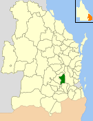
The Shire of Crows Nest was a local government area in the Darling Downs region of Queensland, Australia, immediately northeast of the regional city of Toowoomba. The shire, administered from the town of Crows Nest, covered an area of 1,629.9 square kilometres (629.3 sq mi), and existed as a local government entity from 1913 until 2008, when it amalgamated with several other councils in the Toowoomba area to form the Toowoomba Region. Its growth in later years has been fuelled by the expansion of Toowoomba, particularly the suburbs of Highfields and Blue Mountain Heights which, with a combined population of 7,333 in 2006, were home to over half the shire's population.

<span class="mw-page-title-main">Meringandan</span> Suburb of Toowoomba Region, Queensland, Australia

Meringandan is a rural locality in the Toowoomba Region, Queensland, Australia. In the 2016 census, Meringandan had a population of 487 people.

Gowrie Junction is a rural locality in the Toowoomba Region, Queensland, Australia. It is north-west of Toowoomba. In the 2021 census, Gowrie Junction had a population of 2,030 people. The town of Gowrie is in the eastern part of the locality.

<span class="mw-page-title-main">Crows Nest, Queensland</span> Town in Queensland, Australia

Crows Nest is a rural town and locality in the Toowoomba Region, Queensland, Australia. The town is located in the Darling Downs on the New England Highway, 158 kilometres (98 mi) from the state capital, Brisbane and 43 kilometres (27 mi) from the nearby city of Toowoomba. In the 2016 census, Crows Nest had a population of 2160 people.

<span class="mw-page-title-main">Kingsthorpe, Queensland</span> Town in Queensland, Australia

Kingsthorpe is a rural town and locality in the Toowoomba Region, Queensland, Australia. In the 2021 census, the locality of Kingsthorpe had a population of 2,159 people.

<span class="mw-page-title-main">Cabarlah, Queensland</span> Town in Queensland, Australia

Cabarlah is a rural town and locality in the Toowoomba Region, Queensland, Australia. In the 2016 census the locality of Cabarlah had a population of 1,075 people.

<span class="mw-page-title-main">Goombungee, Queensland</span> Town in Queensland, Australia

Goombungee is a rural town and locality in the Toowoomba Region, Queensland, Australia. In the 2016 census the locality of Goombungee had a population of 1,026 people.

Haden is a rural town and locality in the Toowoomba Region, Queensland, Australia. In the 2016 census, the locality of Haden had a population of 195 people.

<span class="mw-page-title-main">Geham</span> Suburb of Toowoomba Region, Queensland, Australia

Geham is a rural locality in the Toowoomba Region, Queensland, Australia. In the 2021 census, Geham had a population of 470 people.

<span class="mw-page-title-main">Shire of Highfields</span>

The Shire of Highfields is a former local government area on the Darling Downs in Queensland, Australia. It existed between 1879 and 1949.

<span class="mw-page-title-main">Groomsville, Queensland</span> Suburb of Toowoomba Region, Queensland, Australia

Groomsville is a rural locality in the Toowoomba Region on the Darling Downs, Queensland, Australia. In the 2021 census, Groomsville had a population of 132 people.

<span class="mw-page-title-main">Glencoe, Queensland</span> Suburb of Toowoomba Region, Queensland, Australia

Glencoe is a rural locality in the Toowoomba Region, Queensland, Australia. In the 2016 census,Glencoe had a population of 322 people.

<span class="mw-page-title-main">Boodua, Queensland</span> Suburb of Toowoomba Region, Queensland, Australia

Boodua is a rural locality in the Toowoomba Region, Queensland, Australia. In the 2016 census Boodua had a population of 93 people.

<span class="mw-page-title-main">Gowrie Little Plain, Queensland</span> Suburb of Toowoomba Region, Queensland, Australia

Gowrie Little Plain is a rural locality in the Toowoomba Region, Queensland, Australia. In the 2021 census, Gowrie Little Plain had a population of 79 people.

<span class="mw-page-title-main">Bergen, Queensland</span> Suburb of Toowoomba Region, Queensland, Australia

Bergen is a rural locality in the Toowoomba Region, Queensland, Australia. In the 2016 census, Bergen had a population of 68 people.

Pinelands is a rural locality in the Toowoomba Region, Queensland, Australia. In the 2016 census, Pinelands had a population of 86 people.

<span class="mw-page-title-main">Douglas, Queensland (Toowoomba Region)</span> Suburb of Toowoomba Region, Queensland, Australia

Douglas is a rural locality in the Toowoomba Region, Queensland, Australia. In the 2016 census, Douglas had a population of 112 people.

Doctor Creek is a rural locality in the Toowoomba Region, Queensland, Australia. In the 2016 census, Doctor Creek had a population of 37 people.

Emu Creek is a rural locality in the Toowoomba Region, Queensland, Australia. In the 2021 census, Emu Creek had a population of 113 people.

Upper Pinelands is a rural locality in the Toowoomba Region, Queensland, Australia. In the 2016 census, Upper Pinelands had a population of 33 people.

References

  1. 1 2 3 Australian Bureau of Statistics (27 June 2017). "Glenaven (SSC)". 2016 Census QuickStats. Retrieved 20 October 2018. OOjs UI icon edit-ltr-progressive.svg
  2. 1 2 "Glenaven – locality in Toowoomba Region (entry 49233)". Queensland Place Names. Queensland Government . Retrieved 19 September 2020.
  3. 1 2 3 4 5 6 "Queensland Globe". State of Queensland . Retrieved 23 June 2023.
  4. Queensland Family History Society (2010), Queensland schools past and present (Version 1.01 ed.), Queensland Family History Society, ISBN   978-1-921171-26-0
  5. "Parish of Djuan" (Map). Queensland Government. 1935. Archived from the original on 30 October 2020. Retrieved 30 October 2020.
  6. "METHODIST SYNOD". Darling Downs Gazette . Vol. XLIII, no. 10, 027. Queensland, Australia. 28 October 1901. p. 3. Retrieved 31 October 2020 via National Library of Australia.
  7. Blake, Thom. "Glenaven Methodist Church". Queensland religious places database. Retrieved 11 June 2022.
  8. "CROW'S NEST". The Brisbane Courier . No. 20, 852. Queensland, Australia. 21 November 1924. p. 11. Retrieved 24 June 2023 via National Library of Australia.
  9. "Gowrie Flat Methodist Church | Djuan". Queensland Religious Places Database. Retrieved 24 June 2023.
  10. "Parish of Djuan sheet 1" (Map). Queensland Government. 1935. Retrieved 23 June 2023.