Mount Emlyn, Queensland

Last updated

Mount Emlyn
Queensland
Australia Queensland location map.svg
Red pog.svg
Mount Emlyn
Coordinates 28°02′00″S151°18′00″E / 28.0333°S 151.3°E / -28.0333; 151.3 (Mount Emlyn (centre of locality))
Population0 (2021 census) [1]
 • Density0.000/km2 (0.00/sq mi)
Postcode(s) 4357
Area24.1 km2 (9.3 sq mi)
Time zone AEST (UTC+10:00)
LGA(s) Toowoomba Region
State electorate(s) Southern Downs
Federal division(s) Maranoa
Suburbs around Mount Emlyn:
Lavelle Lavelle Rocky Creek
Kooroongarra Mount Emlyn Rocky Creek
Kooroongarra Kooroongarra Kooroongarra

Mount Emlyn is a rural locality in the Toowoomba Region of Queensland, Australia. [2] In the 2021 census, Mount Emlyn had "no people or a very low population". [1]

Contents

Geography

Mount Emlyn is in the north-east of the locality ( 28°01′42″S151°18′47″E / 28.0282°S 151.3131°E / -28.0282; 151.3131 (Mount Emlyn) ) at 590 metres (1,940 ft) above sea level. [3] [4]

History

The locality is named after the mountain, which was originally known as Mount Allys, which was the family name of Lord Cawdor of the British House of Peers. It was renamed Mount Emlyn in the late 1800s, after the second wife of Francis Arthur Gore, grazier of Yandilla Station. [2] [4] [5]

Mount Emlyn Provisional School opened on 10 May 1920. In 1948 it became Mount Emylyn State School. It closed on 21 April 1957. [6] [7]

Demographics

In the 2016 census Mount Emlyn had a population of 16 people. [8]

In the 2021 census, Mount Emlyn had "no people or a very low population". [1]

Related Research Articles

<span class="mw-page-title-main">Kingsthorpe, Queensland</span> Town in Queensland, Australia

Kingsthorpe is a rural town and locality in the Toowoomba Region, Queensland, Australia. In the 2021 census, the locality of Kingsthorpe had a population of 2,159 people.

<span class="mw-page-title-main">Ballard, Queensland</span> Suburb of Lockyer Valley Region, Queensland, Australia

Ballard is a rural locality in the Lockyer Valley Region, Queensland, Australia. In the 2021 census, Ballard had a population of 167 people.

<span class="mw-page-title-main">Vale View, Queensland</span> Suburb of Toowoomba, Queensland, Australia

Vale View is a rural locality in the Toowoomba Region, Queensland, Australia. In the 2021 census, Vale View had a population of 454 people.

Cranley is a rural locality in the Toowoomba Region, Queensland, Australia. In the 2021 census, Cranley had a population of 2,281 people.

<span class="mw-page-title-main">Mount Kynoch, Queensland</span> Suburb of Toowoomba, Queensland, Australia

Mount Kynoch is a rural locality in the Toowoomba Region, Queensland, Australia. In the 2021 census, Mount Kynoch had a population of 271 people.

<span class="mw-page-title-main">North Toowoomba, Queensland</span> Suburb of Toowoomba, Queensland, Australia

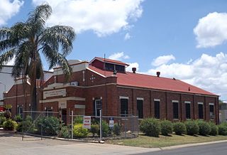
North Toowoomba is a suburban locality in Toowoomba in the Toowoomba Region, Queensland, Australia. In the 2021 census, North Toowoomba had a population of 3,332 people.

<span class="mw-page-title-main">Mount Tyson, Queensland</span> Town in Queensland, Australia

Mount Tyson is a rural town and locality in the Toowoomba Region, Queensland, Australia. In the 2021 census, the locality of Mount Tyson had a population of 280 people.

<span class="mw-page-title-main">East Greenmount, Queensland</span> Town in Queensland, Australia

East Greenmount is a rural town and locality in the Toowoomba Region, Queensland, Australia. In the 2021 census, the locality of East Greenmount had a population of 351 people.

<span class="mw-page-title-main">Ascot, Queensland (Toowoomba Region)</span> Suburb of Toowoomba Region, Queensland, Australia

Ascot is a rural locality in the Toowoomba Region, Queensland, Australia. In the 2021 census, Ascot had a population of 106 people.

<span class="mw-page-title-main">Felton, Queensland</span> Suburb of Toowoomba Region, Queensland, Australia

Felton is a rural locality in the Toowoomba Region, Queensland, Australia. In the 2021 census, Felton had a population of 267 people.

<span class="mw-page-title-main">Linthorpe, Queensland</span> Suburb of Toowoomba Region, Queensland, Australia

Linthorpe is a rural locality in the Toowoomba Region, Queensland, Australia. In the 2021 census, Linthorpe had a population of 416 people.

<span class="mw-page-title-main">Mount Irving, Queensland</span> Suburb of Toowoomba Region, Queensland, Australia

Mount Irving is a rural locality in the Toowoomba Region, Queensland, Australia. In the 2021 census, Mount Irving had a population of 34 people.

<span class="mw-page-title-main">Meringandan West, Queensland</span> Suburb of Toowoomba Region, Queensland, Australia

Meringandan West is a rural locality in the Toowoomba Region, Queensland, Australia. In the 2021 census, Meringandan West had a population of 2,488 people.

Captains Mountain is a locality in the Toowoomba Region, Queensland, Australia. In the 2021 census, Captains Mountain had a population of 74 people.

Ramsay is a rural locality in the Toowoomba Region, Queensland, Australia. In the 2021 census, Ramsay had a population of 369 people.

Evanslea is a rural locality in the Toowoomba Region, Queensland, Australia. In the 2021 census, Evanslea had a population of 31 people.

Kilbirnie is a rural locality in the Toowoomba Region, Queensland, Australia. In the 2021 census, Kilbirnie had a population of 68 people.

Stoneleigh is a rural locality in the Toowoomba Region, Queensland, Australia. In the 2021 census, Stoneleigh had a population of 124 people.

Cutella is a rural locality in the Toowoomba Region, Queensland, Australia. In the 2021 census, Cutella had a population of 45 people.

Emu Creek is a rural locality in the Toowoomba Region, Queensland, Australia. In the 2021 census, Emu Creek had a population of 113 people.

References

  1. 1 2 3 Australian Bureau of Statistics (28 June 2022). "Mount Emlyn (SAL)". 2021 Census QuickStats. Retrieved 28 February 2023. OOjs UI icon edit-ltr-progressive.svg
  2. 1 2 "Mount Emlyn – locality in Toowoomba Region (entry 48009)". Queensland Place Names. Queensland Government . Retrieved 29 December 2020.
  3. "Mountain peaks and capes - Queensland". Queensland Open Data. Queensland Government. 12 November 2020. Archived from the original on 25 November 2020. Retrieved 25 November 2020.
  4. 1 2 "Mount Emlyn – mountain in Toowoomba Region (entry 11618)". Queensland Place Names. Queensland Government . Retrieved 25 November 2020.
  5. "Obituary". Darling Downs Gazette . Vol. XLVI, no. 11034. Queensland, Australia. 20 January 1904. p. 2. Retrieved 18 January 2021 via National Library of Australia.
  6. Queensland Family History Society (2010), Queensland schools past and present (Version 1.01 ed.), Queensland Family History Society, ISBN   978-1-921171-26-0
  7. "Agency ID 5891, Mount Emlyn State School". Queensland State Archives . Retrieved 18 January 2021.
  8. Australian Bureau of Statistics (27 June 2017). "Mount Emlyn (SSC)". 2016 Census QuickStats. Retrieved 20 October 2018. OOjs UI icon edit-ltr-progressive.svg