Peranga, Queensland

Last updated

Peranga
Queensland
Australia Queensland location map.svg
Red pog.svg
Peranga
Coordinates 27°08′45″S151°41′46″E / 27.1458°S 151.6961°E / -27.1458; 151.6961 (Peranga (town centre))
Population85 (2016 census) [1]
 • Density2.843/km2 (7.36/sq mi)
Postcode(s) 4352
Area29.9 km2 (11.5 sq mi)
Time zone AEST (UTC+10:00)
Location
LGA(s) Toowoomba Region
State electorate(s) Condamine
Federal division(s) Groom
Localities around Peranga:
Quinalow Maclagan Narko
Quinalow Peranga Evergreen
Quinalow Kulpi Kulpi

Peranga is a rural town and locality in the Toowoomba Region, Queensland, Australia. [2] [3] In the 2016 census the locality of Peranga had a population of 85 people. [1]

Contents

Geography

Peranga is a small town on the Darling Downs, 70 kilometres (43 mi) north-west of Toowoomba and 55 kilometres (34 mi) north-east of Dalby.

History

The name Peranga derives from the name of an outstation on Rosalie Plains pastoral run, assigned when the town was surveyed in 1911. [2]

Peranga Post Office opened on 11 January 1913. [4]

Peranga State School opened in 1915, closing on 30 July 1973. [5]

The Peranga & District Bowls Club opened in 1955.

The Anglican Church of St John the Evangelist was consecrated circa 1959. Its last service was held on 13 May 1961 due to a reduction in the congregation. [6]

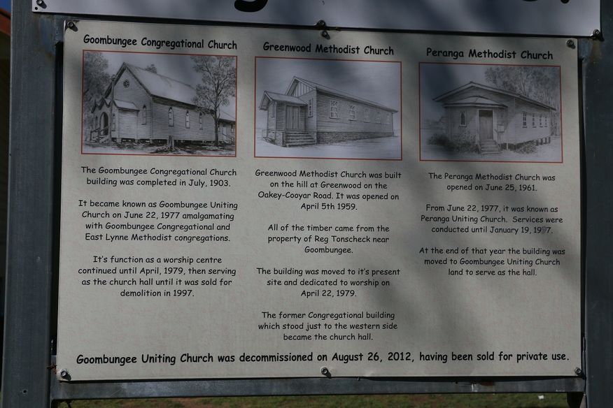
Peranga Methodist Church opened on 25 June 1961. When the Methodist Church amalgamated into the Uniting Church in Australia, it became Peranga Uniting Church on 22 June 1977. The last service was held in Peranga on 19 January 1997, after which the church building was relocated to Goombungee to be used as the hall for the Goombungee Uniting Church. [7] [8] The Goombungee church and hall were sold into private ownership in 2012 for $185,000, but the buildings are still extent (as at 2020). [9]

Once the prosperous hub of a rich dairy-producing area, Peranga went into sharp decline after the closure of the Oakey-Cooyar railway line in the mid-1960s. The hotel burnt down in 1967, followed by the school's closure in 1973. [10]

At the 2011 census, Peranga and the surrounding area had a population of 298. [11]

At the 2011 census Peranga had a population of 298 people. [11]

In the 2016 census the locality of Peranga had a population of 85 people. [1]

Education

There are no schools in Peranga. The nearest primary schools are Quinalow State School in neighbouring Quinalow to the west and Kulpi State School in neighbouring Kulpi to the south. The nearest secondary schools are Quinalow State School (to Year 10) in Quinalow and Oakey State High School in Oakey to the south. [12]

Amenities

The Peranga & District Bowls Club is still in operation. There is a post office and general store, a one-man police station and a town hall.

Together with Peranga, the surrounding towns of Quinalow (10 km west), Maclagan (13 km north-west) and Kulpi (9 km south) are interdependent, having between them all the amenities of a small town. Kulpi has a hotel and tennis courts; Quinalow a garage, cafe, hotel, rural supplier, school, swimming pool, caravan park, library, tractor dealership, tennis courts, hall, and skate park; and Maclagan has a post office and general store, two wineries, a small museum, a butcher, a kindergarten and several parks.

Related Research Articles

<span class="mw-page-title-main">Oakey, Queensland</span> Town in Queensland, Australia

Oakey is a rural town and locality in the Toowoomba Region, Queensland, Australia. The Museum of Army Aviation is located at Oakey Airport.

The Cooyar railway line was a branch line in the Darling Downs region of Queensland, Australia. The small town of Cooyar is about halfway to Kingaroy in the South Burnett Region. A plan to connect Kingaroy to the south via Cooyar did not eventuate and left Cooyar at the terminus of a branch line running from Oakey west of Toowoomba. It was opened on 28 April 1913 after previous stages to Kulpi and Peranga opened on 29 April 1912 and 4 November 1912 respectively. The line was partially closed beyond Acland on 1 May 1964, with the last segment closed on 8 December 1969.

<span class="mw-page-title-main">Acland, Queensland</span> Town in Queensland, Australia

Acland is a rural town and locality in the Toowoomba Region, Queensland, Australia. In the 2016 census the locality of Acland had a population of 32 people.

<span class="mw-page-title-main">Goombungee, Queensland</span> Town in Queensland, Australia

Goombungee is a rural town and locality in the Toowoomba Region, Queensland, Australia. In the 2016 census the locality of Goombungee had a population of 1,026 people.

<span class="mw-page-title-main">Quinalow</span> Town in Queensland, Australia

Quinalow is a rural town and locality in the Toowoomba Region, Queensland, Australia. In the 2016 census the locality of Quinalow had a population of 173 people.

Haden is a rural town and locality in the Toowoomba Region, Queensland, Australia. In the 2016 census, the locality of Haden had a population of 195 people.

<span class="mw-page-title-main">Aubigny, Queensland</span> Town in Queensland, Australia

Aubigny is a rural town and locality in the Toowoomba Region, Queensland, Australia. In the 2016 census, the locality of Aubigny had a population of 254 people.

<span class="mw-page-title-main">Maclagan, Queensland</span> Town in Queensland, Australia

Maclagan is a rural town and locality in the Toowoomba Region, Queensland, Australia. In the 2016 census the locality of Maclagan had a population of 195 people.

Kulpi is a rural town and locality in the Toowoomba Region, Queensland, Australia. In the 2016 census, the locality of Kulpi had a population of 77 people.

<span class="mw-page-title-main">Boodua, Queensland</span> Suburb of Toowoomba Region, Queensland, Australia

Boodua is a rural locality in the Toowoomba Region, Queensland, Australia. In the 2016 census Boodua had a population of 93 people.

<span class="mw-page-title-main">Gowrie Little Plain, Queensland</span> Suburb of Toowoomba Region, Queensland, Australia

Gowrie Little Plain is a rural locality in the Toowoomba Region, Queensland, Australia. In the 2021 census, Gowrie Little Plain had a population of 79 people.

Evergreen is a rural town and locality in the Toowoomba Region, Queensland, Australia. In the 2016 census, the locality of Evergreen had a population of 45 people.

Greenwood is a rural locality in the Toowoomba Region, Queensland, Australia. In the 2016 census, Greenwood had a population of 40 people.

Silverleigh is a rural locality in the Toowoomba Region, Queensland, Australia. In the 2016 census, Silverleigh had a population of 71 people.

<span class="mw-page-title-main">Douglas, Queensland (Toowoomba Region)</span> Suburb of Toowoomba Region, Queensland, Australia

Douglas is a rural locality in the Toowoomba Region, Queensland, Australia. In the 2016 census, Douglas had a population of 112 people.

Highland Plains is a rural locality in the Toowoomba Region, Queensland, Australia. In the 2021 census, Highland Plains had a population of 60 people.

Cutella is a rural locality in the Toowoomba Region, Queensland, Australia. In the 2021 census, Cutella had a population of 45 people.

Mount Darry is a rural locality in the Toowoomba Region, Queensland, Australia. In the 2016 census Mount Darry had a population of 35 people.

Oakey–Cooyar Road is a continuous 58.8 kilometres (36.5 mi) road route in the Darling Downs and Toowoomba regions of Queensland, Australia. The entire route is signed as State Route 68. It is a state-controlled part regional and part district road. It provides an alternate route between the Warrego Highway and the New England Highway, bypassing Toowoomba.

The roads that join the towns of Dalby, Toowoomba and Cooyar form a triangle that encloses some of the most fertile land on the Darling Downs in Queensland, Australia. These roads are the Warrego Highway, New England Highway and Dalby–Cooyar Road. Pechey–Maclagan Road forms a large part of a group of roads that bisect the triangle from east to west, and is also part of one of the groups of roads that bisect from south to north.

References

  1. 1 2 3 Australian Bureau of Statistics (27 June 2017). "Peranga (SSC)". 2016 Census QuickStats. Retrieved 20 October 2018. OOjs UI icon edit-ltr-progressive.svg
  2. 1 2 "Peranga – town in Toowoomba Region (entry 26425)". Queensland Place Names. Queensland Government . Retrieved 29 December 2020.
  3. "Peranga – locality in Toowoomba Region (entry 48035)". Queensland Place Names. Queensland Government . Retrieved 29 December 2020.
  4. Premier Postal History. "Post Office List". Premier Postal Auctions. Archived from the original on 15 May 2014. Retrieved 10 May 2014.
  5. Queensland Family History Society (2010), Queensland schools past and present (Version 1.01 ed.), Queensland Family History Society, ISBN   978-1-921171-26-0
  6. "Closed Churches". Anglican Church Southern Queensland. Archived from the original on 3 April 2019. Retrieved 31 May 2019.
  7. "Noticeboard outside Goombungee Uniting Church, 6 George Street". Churches Australia. Archived from the original on 17 December 2020. Retrieved 17 December 2020.
  8. "6 George Street Goombungee Qld 4354". Realestate.com.au . Retrieved 17 December 2020.
  9. "6 George Street Goombungee Qld 4354". Realestate.com.au . Retrieved 17 December 2020.
  10. Garrad, Janette (24 January 2013). "Peranga - a short history". State Library Of Queensland. Retrieved 18 September 2023.
  11. 1 2 Australian Bureau of Statistics (31 October 2012). "Peranga (State Suburb)". 2011 Census QuickStats. Retrieved 1 July 2013. OOjs UI icon edit-ltr-progressive.svg
  12. "Queensland Globe". State of Queensland . Retrieved 5 March 2021.