Gilla, Queensland

Last updated

Map all coordinates using: OpenStreetMap  
Download coordinates as: KML
Gilla
Queensland
Australia Queensland location map.svg
Red pog.svg
Gilla
Coordinates 26°54′47″S152°01′05″E / 26.9130°S 152.0180°E / -26.9130; 152.0180 (Gilla (centre of locality))
Population32 (2016 census) [1]
 • Density0.360/km2 (0.932/sq mi)
Postcode(s) 4314
Area88.9 km2 (34.3 sq mi)
Time zone AEST (UTC+10:00)
LGA(s) Toowoomba Region
State electorate(s) Nanango
Federal Division(s) Maranoa
Suburbs around Gilla:
Yarraman Yarraman Nukku
Upper Yarraman
Kooralgin
Gilla Blackbutt South
Kooralgin Mount Binga Googa Creek

Gilla is a rural locality in the Toowoomba Region, Queensland, Australia. [2] In the 2016 census Gilla had a population of 32 people. [1]

Contents

Geography

Gilla is loosely bounded to the south-east by the Blackbutt Range ( 26°56′00″S152°01′00″E / 26.9333°S 152.0166°E / -26.9333; 152.0166 (Blackbutt Range) ), exending into neighbouring localities of Blackbutt South, Googa Creek, Mount Binga and beyond. [3] [4]

Pidna is a neighbourhood on the northern edge of the locality ( 26°52′00″S152°01′00″E / 26.8666°S 152.0166°E / -26.8666; 152.0166 (Pidna) ). [5]

The Pockets is a neighbourhood near the south-eastern edge of the locality ( 26°55′00″S152°03′00″E / 26.9166°S 152.05°E / -26.9166; 152.05 (The Pockets) ). [6]

The north-west of the locality is a protected area within the Pidna National Park ( 26°53′29″S151°58′16″E / 26.8914°S 151.9711°E / -26.8914; 151.9711 (Pidna National Park) ) and the Pidna State Forest ( 26°52′29″S151°59′13″E / 26.8747°S 151.9869°E / -26.8747; 151.9869 (Pidna State Forest) ). [3] [7] [8] The south-east of the locality is a protected area within the Googa State Forest ( 26°55′22″S152°01′45″E / 26.9227°S 152.0291°E / -26.9227; 152.0291 (Googa State Forest) ) which extending into neighbouring Googa Creek. [3] [9]

Apart from the protected areas, the predominant land use is grazing on native vegetation. [3]

The D'Aigular Highway enters the locality from the north-east (Nukku) and exits to the north (Yarraman). [3]

The former Brisbane Valley railway line entered the locality from the north-east (Nukka) just to the south-east of the highway and exited to the north (Yarraman) immediately to the east of the highway. Gilla railway station is an abandoned railway station on the railway line in the north of the locality ( 26°52′40″S152°02′21″E / 26.8777°S 152.0393°E / -26.8777; 152.0393 (Gilla railway station) ). [10]

The Ted Pukallus Weir is a dam structure on Cooyar Creek to create a water reservoir to supply drinking water to the Yarraman area. [11]

History

The locality takes its name from the former Gilla railway station name which was named on 19 December 1912 using an Aboriginal word from the Wakawaka language, Bujiebara dialect, meaning native bee. [2]

Pidna is a Yuggera and/or Waka language word meaning ear . [5]

Ninety-three (93) Mile Camp Provisional School opened on 1912. In 1913 it was renamed Gilla Provisional School. It closed circa 1922. [12]

The Ted Pukallus Weir was originally completed in 1967. It was badly damaged in the 2011 Queensland floods and required $9.5M worth of repairs which were completed in 2013. [11]

In the 2016 census Gilla had a population of 32 people. [1]

Economy

There are a number of homesteads in the locality, including: [13]

Attractions

The Ted Pukallus Weir on Gilla Road ( 26°52′27″S152°01′34″E / 26.8742°S 152.0261°E / -26.8742; 152.0261 (Ted Pukallus Weir) ) is a popular fishing spot. [14]

Related Research Articles

Yarraman, Queensland Town in Queensland, Australia

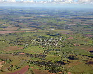
Yarraman is a rural town and locality in the Toowoomba Region, Queensland, Australia. In the 2016 census, Yarraman had a population of 1,064 people.

Kaimkillenbun Town in Queensland, Australia

Kaimkillenbun is a rural town and locality in the Western Downs Region, Queensland, Australia. In the 2016 census the locality of Kaimkillenbun had a population of 293 people.

Blackbutt, Queensland Town in Queensland, Australia

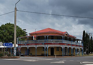
Blackbutt is a rural town and locality in the South Burnett Region, Queensland, Australia. In the 2016 census, Blackbutt had a population of 836 people.

Brisbane Valley railway line

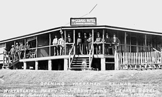
The Brisbane Valley railway line was a railway connection in Queensland, Australia connecting Ipswich, west of Brisbane, to the upper Brisbane River valley. Progressively opened between 1884 and 1913 the railway provided a vital transport link between Ipswich and Yarraman and forged development and prosperity along its path. The line acquired its serpentine reputation because it did not take a straight course when faced with a hill or gully.

Ideraway Town in Queensland, Australia

Ideraway is a rural town and locality in the North Burnett Region, Queensland, Australia. In the 2016 census the locality of Ideraway had a population of 38 people.

Benarkin Town in Queensland, Australia

Benarkin is a rural town and locality in the South Burnett Region, Queensland, Australia. The nearby town of Blackbutt is the origin of the town and the two towns are often referred to as the joint entity Blackbutt-Benarkin. In the 2016 census, Benarkin had a population of 61 people.

Upper Yarraman, Queensland Suburb of Toowoomba Region, Queensland, Australia

Upper Yarraman is a rural locality in the Toowoomba Region, Queensland, Australia. In the 2016 census, Upper Yarraman had a population of 104 people.

Spring Creek, Queensland (Darling Downs) Suburb of Toowoomba Region, Queensland, Australia

Spring Creek is a locality split between the Toowoomba Region and the Southern Downs Region, Queensland, Australia.

Ramsay, Queensland Suburb of Toowoomba Region, Queensland, Australia

Ramsay is a rural locality in the Toowoomba Region, Queensland, Australia. In the 2016 census Ramsay had a population of 348 people.

Didcot, Queensland Suburb of North Burnett Region, Queensland, Australia

Didcot is a rural locality in the North Burnett Region, Queensland, Australia. In the 2016 census Didcot had a population of 60 people.

Evanslea, Queensland Suburb of Toowoomba Region, Queensland, Australia

Evanslea is a rural locality in the Toowoomba Region, Queensland, Australia. In the 2016 census Evanslea had a population of 41 people.

Haly Creek, Queensland Suburb of South Burnett Region, Queensland, Australia

Haly Creek is a rural locality in the South Burnett Region, Queensland, Australia. In the 2016 census Haly Creek had a population of 136 people.

Brookstead, Queensland Town in Queensland, Australia

Brookstead is a rural town and locality in the Toowoomba Region, Queensland, Australia. In the 2016 census, Brookstead had a population of 217 people.

Moffatdale, Queensland Suburb of South Burnett Region, Queensland, Australia

Moffatdale is a rural locality in the South Burnett Region, Queensland, Australia. In the 2016 census Moffatdale had a population of 179 people.

Nangwee, Queensland Town in Queensland, Australia

Nangwee is a rural town and locality in the Toowoomba Region, Queensland, Australia. In the 2016 census the locality of Nangwee had a population of 52 people.

Nutgrove, Queensland Suburb of Toowoomba Region, Queensland, Australia

Nutgrove is a rural locality in the Toowoomba Region, Queensland, Australia. In the 2016 census Nutgrove had a population of 32 people.

Nukku Suburb of South Burnett Region, Queensland, Australia

Nukku is a rural locality in the South Burnett Region, Queensland, Australia. In the 2016 census Nukku had a population of 22 people.

Jinghi, Queensland Suburb of Western Downs Region, Queensland, Australia

Jinghi is a rural locality in the Western Downs Region, Queensland, Australia. In the 2016 census Jinghi had a population of 74 people.

Googa Creek Suburb of Toowoomba Region, Queensland, Australia

Googa Creek is a rural locality in the Toowoomba Region, Queensland, Australia. In the 2016 census Googa Creek had a population of 43 people.

Mount Darry, Queensland Suburb of Toowoomba Region, Queensland, Australia

Mount Darry is a rural locality in the Toowoomba Region, Queensland, Australia. In the 2016 census Mount Darry had a population of 35 people.

References

  1. 1 2 3 Australian Bureau of Statistics (27 June 2017). "Gilla (SSC)". 2016 Census QuickStats. Retrieved 20 October 2018. OOjs UI icon edit-ltr-progressive.svg
  2. 1 2 "Gilla – locality in Toowoomba Region (entry 47947)". Queensland Place Names. Queensland Government . Retrieved 29 December 2020.
  3. 1 2 3 4 5 "Queensland Globe". State of Queensland . Retrieved 31 December 2020.
  4. "Blackbutt Range – range in Toowoomba Regional (entry 2991)". Queensland Place Names. Queensland Government . Retrieved 29 December 2020.
  5. 1 2 "Pidna – locality unbounded in Toowoomba Regional (entry 26651)". Queensland Place Names. Queensland Government . Retrieved 29 December 2020.
  6. "The Pockets – locality unbounded in Toowoomba Regional (entry 34074)". Queensland Place Names. Queensland Government . Retrieved 29 December 2020.
  7. "Pidna National Park – national park in the Toowoomba Region (entry 44073)". Queensland Place Names. Queensland Government . Retrieved 1 January 2021.
  8. "Pidna State Forest – state forest in the Toowoomba Region (entry 26652)". Queensland Place Names. Queensland Government . Retrieved 1 January 2021.
  9. "Googa State Forest – state forest in the Toowoomba Region (entry 14237)". Queensland Place Names. Queensland Government . Retrieved 1 January 2021.
  10. "Railway stations and sidings - Queensland". Queensland Open Data. Queensland Government. 2 October 2020. Archived from the original on 5 October 2020. Retrieved 5 October 2020.
  11. 1 2 "Ted Pukallus Weir Remediation". CMC Group. Archived from the original on 1 January 2021. Retrieved 1 January 2021.
  12. Queensland Family History Society (2010), Queensland schools past and present (Version 1.01 ed.), Queensland Family History Society, ISBN   978-1-921171-26-0
  13. "Homesteads - Queensland". Queensland Open Data. Queensland Government. 18 November 2020. Archived from the original on 24 November 2020. Retrieved 24 November 2020.
  14. "South Burnett Tourism - Yarraman". Tourism South Burnett. Archived from the original on 1 January 2021. Retrieved 1 January 2021.