Glan Devon, Queensland

Last updated

Glan Devon
Queensland
Australia Queensland location map.svg
Red pog.svg
Glan Devon
Coordinates 26°37′09″S152°01′19″E / 26.6191°S 152.0219°E / -26.6191; 152.0219 Coordinates: 26°37′09″S152°01′19″E / 26.6191°S 152.0219°E / -26.6191; 152.0219
Population248 (2016 census) [1]
 • Density7.168/km2 (18.56/sq mi)
Postcode(s) 4615
Area34.6 km2 (13.4 sq mi)
Time zone AEST (UTC+10:00)
LGA(s) South Burnett Region
State electorate(s) Nanango
Federal Division(s) Maranoa
Suburbs around Glan Devon:
Booie Sandy Ridges Runnymede
Booie Glan Devon Bullcamp
Barker Creek Flat Nanango East Nanango

Glan Devon is a rural locality in the South Burnett Region, Queensland, Australia. [2] In the 2016 census, Glan Devon had a population of 248 people. [1]

History

Grindstone Provisional School opened in 1907. On 1 January 1909 it became Grindstone State School. It closed in 1957. [3] It was located on the north side of Grindstone School Road ( 26°37′09″S152°01′26″E / 26.6191°S 152.0238°E / -26.6191; 152.0238 (Grindstone State School (former)) ). [4]

Related Research Articles

Blackbutt, Queensland Town in Queensland, Australia

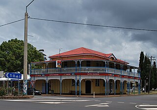
Blackbutt is a rural town and locality in the South Burnett Region, Queensland, Australia. In the 2016 census, Blackbutt had a population of 836 people.

Brooloo, Queensland Town in Queensland, Australia

Brooloo is a rural town and locality in the Gympie Region, Queensland, Australia. In the 2016 census the locality of Brooloo had a population of 348 people.

Degilbo Town in Queensland, Australia

Degilbo is a town and a locality in the North Burnett Region, Queensland, Australia. In the 2016 census, Degilbo had a population of 174 people.

South Kolan Town in Queensland, Australia

South Kolan is a rural locality in the Bundaberg Region, Queensland, Australia. In the 2016 census, South Kolan had a population of 1,061 people.

Allenview, Queensland Suburb of Scenic Rim Region, Queensland, Australia

Allenview is a rural locality in the Scenic Rim Region, Queensland, Australia. In the 2016 census, Allenview had a population of 184 people.

Mon Repos, Queensland Suburb of Bundaberg Region, Queensland, Australia

Mon Repos is a coastal locality in the Bundaberg Region, Queensland, Australia. In the 2016 census Mon Repos had a population of 30 people.

Spring Creek, Queensland (Darling Downs) Suburb of Toowoomba Region, Queensland, Australia

Spring Creek is a locality split between the Toowoomba Region and the Southern Downs Region, Queensland, Australia.

Owanyilla, Queensland Town in Queensland, Australia

Owanyilla is a rural town and locality in the Fraser Coast Region, Queensland, Australia. In the 2016 census the locality of Owanyilla had a population of 194 people.

Moffatdale, Queensland Suburb of South Burnett Region, Queensland, Australia

Moffatdale is a rural locality in the South Burnett Region, Queensland, Australia. In the 2016 census Moffatdale had a population of 179 people.

Monogorilby, Queensland Suburb of North Burnett Region, Queensland, Australia

Monogorilby is a locality in the North Burnett Region, Queensland, Australia. The neighbourhood of Allies Creek is located in the south-east of Monogorilby.

Bunya Mountains, Queensland Suburb of Western Downs Region, Queensland, Australia

Bunya Mountains is a locality split between the Western Downs Region and the South Burnett Region, Queensland, Australia. The town of Mount Mowbullan is within the locality. In the 2016 census Bunya Mountains had a population of 144 people.

Kinleymore Suburb of South Burnett Region, Queensland, Australia

Kinleymore is a rural locality in the South Burnett Region, Queensland, Australia. In the 2016 census Kinleymore had a population of 93 people.

Lakeside, Queensland Suburb of North Burnett Region, Queensland, Australia

Lakeside is a rural locality in the North Burnett Region, Queensland, Australia. In the 2016 census Lakeside had a population of 55 people.

Merlwood Suburb of South Burnett Region, Queensland, Australia

Merlwood is a rural locality in the South Burnett Region, Queensland, Australia. In the 2016 census Merlwood had a population of 88 people.

Nukku Suburb of South Burnett Region, Queensland, Australia

Nukku is a rural locality in the South Burnett Region, Queensland, Australia. In the 2016 census Nukku had a population of 22 people.

Good Night, Queensland Suburb of Bundaberg Region, Queensland, Australia

Good Night is a rural locality split between the Bundaberg Region and the North Burnett Region, Queensland, Australia. It is also writted as Goodnight. In the 2016 census, Good Night had a population of 117 people.

Mount Mellum, Queensland Suburb of Sunshine Coast Region, Queensland, Australia

Mount Mellum is a rural locality in the Sunshine Coast Region, Queensland, Australia. In the 2016 census Mount Mellum had a population of 442 people.

Gilla, Queensland Suburb of Toowoomba Region, Queensland, Australia

Gilla is a rural locality in the Toowoomba Region, Queensland, Australia. In the 2016 census Gilla had a population of 32 people.

Woowoonga, Queensland Suburb of North Burnett Region, Queensland, Australia

Woowoonga is a locality in the North Burnett Region, Queensland, Australia. In the 2016 census, Woowoonga had a population of 92 people.

East Nanango, Queensland Suburb of South Burnett Region, Queensland, Australia

East Nanango is a rural locality in the South Burnett Region, Queensland, Australia. In the 2016 census, East Nanango had a population of 265 people.

References

  1. 1 2 Australian Bureau of Statistics (27 June 2017). "Glan Devon (SSC)". 2016 Census QuickStats. Retrieved 20 October 2018. OOjs UI icon edit-ltr-progressive.svg
  2. "Glan Devon – locality in South Burnett Region (entry 46219)". Queensland Place Names. Queensland Government . Retrieved 2 August 2019.
  3. Queensland Family History Society (2010), Queensland schools past and present (Version 1.01 ed.), Queensland Family History Society, ISBN   978-1-921171-26-0
  4. "Queensland Two Mile series sheet 2m79" (Map). Queensland Government. 1955. Archived from the original on 19 January 2021. Retrieved 19 January 2021.