Blackbutt is a rural town and locality in the South Burnett Region, Queensland, Australia. In the 2016 census, Blackbutt had a population of 836 people.

Tingoora is a rural town and a locality in the South Burnett Region, Queensland, Australia. In the 2016 census, Tingoora had a population of 273 people.

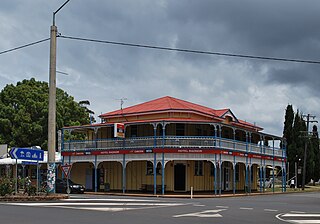
Benarkin is a rural town and locality in the South Burnett Region, Queensland, Australia. The nearby town of Blackbutt is the origin of the town and the two towns are often referred to as the joint entity Blackbutt-Benarkin. In the 2016 census, Benarkin had a population of 61 people.

Riverleigh is a rural locality in the North Burnett Region, Queensland, Australia. In the 2016 census, Riverleigh had a population of 80 people.

Mungungo is a rural town and locality in the North Burnett Region, Queensland, Australia. In the 2016 census, Mungungo had a population of 77 people.
Good Night is a rural locality split between the Bundaberg Region and the North Burnett Region, Queensland, Australia. In the 2016 census, Good Night had a population of 117 people.
Blackbutt North is a rural locality in the South Burnett Region, Queensland, Australia. In the 2016 census, Blackbutt North had a population of 438 people.
Mingo is a rural locality in the North Burnett Region, Queensland, Australia. In the 2016 census, Mingo had a population of 8 people.
Aranbanga is a rural locality in the North Burnett Region, Queensland, Australia. In the 2016 census, Aranbanga had a population of 10 people.
Old Cooranga is a rural locality in the North Burnett Region, Queensland, Australia. In the 2016 census, Old Cooranga had a population of 27 people.
Pile Gully is a rural locality in the North Burnett Region, Queensland, Australia. In the 2016 census, Pile Gully had a population of 3 people.
Harriet is a rural locality in the North Burnett Region, Queensland, Australia. In the 2016 census, Harriet had a population of 4 people.
Deep Creek is a rural locality in the North Burnett Region, Queensland, Australia. In the 2016 census, Deep Creek had a population of 16 people.
Branch Creek is a locality in the North Burnett Region, Queensland, Australia. In the 2016 census, Branch Creek had a population of 32 people.
Yenda is a rural locality in the North Burnett Region, Queensland, Australia. In the 2016 census, Yenda had a population of 23 people.
Wuruma Dam is a rural locality in the North Burnett Region, Queensland, Australia. In the 2016 census, Wuruma Dam had a population of 35 people.
Selene is a rural locality in the North Burnett Region, Queensland, Australia. In the 2016 census, Selene had a population of 25 people.
Cheltenham is a rural locality in the North Burnett Region, Queensland, Australia. In the 2016 census, Cheltenham had a population of 17 people.
Byee is a rural locality in the South Burnett Region, Queensland, Australia. In the 2016 census, Byee had a population of 31 people.
Kawl Kawl is a rural locality in the South Burnett Region, Queensland, Australia. In the 2016 census, Kawl Kawl had a population of 18 people.
