
Kingaroy is a rural city and locality in the South Burnett Region, Queensland, Australia. The city is situated on the junction of the D'Aguilar and the Bunya Highways, 218 kilometres (135 mi) north-west of the state capital Brisbane and 141 kilometres (88 mi) south west of Gympie. In the 2021 census, the locality of Kingaroy had a population of 10,266 people.
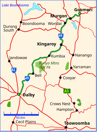
The Bunya Highway is a state highway of Queensland, Australia. It is a relatively short road, running approximately 173 kilometres in a south-westerly direction from Goomeri to Dalby. The highway connects the Warrego and Burnett Highways.

Murgon is a rural town and locality in the South Burnett Region, Queensland, Australia. In the 2021 census, the locality of Murgon had a population of 2,220 people.
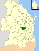
The Shire of Kingaroy was a local government area in the South Burnett area of Queensland, Australia, about 100 kilometres (62 mi) northwest of the capital, Brisbane. The shire covered an area of 2,420.3 square kilometres (934.5 sq mi), and existed as a local government area from 1912 until 2008, when it amalgamated with a number of other local government areas in the South Burnett area to become the South Burnett Region.
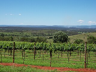
The South Burnett is a peanut growing and wine-producing area on the Great Dividing Range, north of the Darling Downs, in Queensland. It is with the basin of the Burnett River. The area is within two local government areas, South Burnett Region and Gympie Region.

Tingoora is a rural town and a locality in the South Burnett Region, Queensland, Australia.

Wooroolin is a rural town and a locality in the South Burnett Region, Queensland, Australia.

Memerambi is a rural town and locality in the South Burnett Region, Queensland, Australia. In the 2021 census, the locality of Memerambi had a population of 338 people.

Booie is a rural locality in the South Burnett Region, Queensland, Australia. In the 2021 census, Booie had a population of 1,094 people.
Alice Creek is a rural locality in the South Burnett Region, Queensland, Australia. In the 2021 census, Alice Creek had a population of 50 people.

Crawford is a locality in the South Burnett Region, Queensland, Australia. In the 2021 census, Crawford had a population of 182 people.

Moffatdale is a rural locality in the South Burnett Region, Queensland, Australia. In the 2021 census, Moffatdale had a population of 257 people.

Brooklands is a rural locality in the South Burnett Region, Queensland, Australia. In the 2021 census, Brooklands had a population of 324 people.

Cinnabar is a rural locality in the Gympie Region, Queensland, Australia. In the 2021 census, Cinnabar had a population of 83 people.

Corndale is a rural locality in the South Burnett Region, Queensland, Australia. In the 2021 census, Corndale had a population of 58 people.
Cushnie is a rural locality in the South Burnett Region, Queensland, Australia. In the 2021 census, Cushnie had a population of 145 people.
Inverlaw is a rural locality in the South Burnett Region, Queensland, Australia.

Kinbombi is a rural town and locality in the Gympie Region, Queensland, Australia. In the 2021 census, the locality of Kinbombi had a population of 34 people.
Charlestown is a locality in the South Burnett Region, Queensland, Australia. In the 2021 census, Charlestown had a population of 79 people.
Mowbullan is a rural locality in the Western Downs Region, Queensland, Australia. In the 2021 census, Mowbullan had a population of 12 people.
