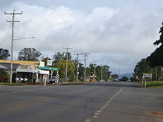
Tolga is a town and locality on the Atherton Tableland in the Tablelands Region in Far North Queensland, Australia. It is the centre of the region's peanut industry. In the 2016 census, Tolga had a population of 2,718 people.

Tinaroo is a rural locality in the Tablelands Region, Queensland, Australia. In the 2016 census, Tinaroo had a population of 312 people. The town of Tinaroo Falls is on the eastern edge of the locality beside Lake Tinaroo.

Tablelands is a rural locality in the Gladstone Region, Queensland, Australia. In the 2016 census, Tablelands had a population of 0 people.

Lamb Range is a locality in the Cairns Region, Queensland, Australia. In the 2016 census, Lamb Range had a population of 0.

Danbulla is a locality in the Tablelands Region, Queensland, Australia. In the 2016 census, Danbulla had a population of 47 people.

Harriet is a rural locality in the North Burnett Region, Queensland, Australia. In the 2016 census, Harriet had a population of 4 people.

Deep Creek is a rural locality in the North Burnett Region, Queensland, Australia. In the 2016 census, Deep Creek had a population of 16 people.

Dirnbir is a rural locality in the North Burnett Region, Queensland, Australia. In the 2016 census, Dirnbir had a population of 49 people.

South East Nanango is a rural locality in the South Burnett Region, Queensland, Australia. In the 2016 census, South East Nanango had a population of 294 people.

Wilkesdale is a rural locality in the South Burnett Region, Queensland, Australia. In the 2016 census, Wilkesdale had a population of 119 people.

Mp Creek is a rural locality in the South Burnett Region, Queensland, Australia. In the 2016 census, Mp Creek had a population of 38 people.

Mount McEuen is a rural locality in the South Burnett Region, Queensland, Australia. In the 2016 census, Mount Mceuen had a population of 36 people.

Coverty is a rural locality in the South Burnett Region, Queensland, Australia. In the 2016 census, Coverty had a population of 167 people.

Byee is a rural locality in the South Burnett Region, Queensland, Australia. In the 2016 census, Byee had a population of 31 people.

Wyalla is a rural locality in the South Burnett Region, Queensland, Australia. In the 2016 census, Wyalla had a population of 37 people.

Marshlands is a rural locality in the South Burnett Region, Queensland, Australia. In the 2016 census, Marshlands had a population of 14 people.

Wigton is a rural locality in the South Burnett Region, Queensland, Australia. In the 2016 census, Wigton had a population of 4 people.

Moondooner is a rural locality in the South Burnett Region, Queensland, Australia. In the 2016 census, Moondooner had a population of 58 people.

Kunioon is a rural locality in the South Burnett Region, Queensland, Australia. In the 2016 census, Kunioon had a population of 31 people.

Palmerston is a rural locality split between the Tablelands Region and the Cassowary Coast Region, Queensland, Australia. In the 2016 census, Palmerston had a population of 3 people.


