Cushnie, Queensland

Last updated

Map all coordinates using: OpenStreetMap  
Download coordinates as: KML
Cushnie
Queensland
Australia Queensland location map.svg
Red pog.svg
Cushnie
Coordinates 26°20′29″S151°44′34″E / 26.3413°S 151.7427°E / -26.3413; 151.7427 (Cushnie (centre of locality)) Coordinates: 26°20′29″S151°44′34″E / 26.3413°S 151.7427°E / -26.3413; 151.7427 (Cushnie (centre of locality))
Population145 (SAL 2021) [1]
Postcode(s) 4608
Area78.2 km2 (30.2 sq mi)
Time zone AEST (UTC+10:00)
Location
LGA(s) South Burnett Region
State electorate(s) Nanango
Federal division(s) Flynn
Suburbs around Cushnie:
Melrose Mp Creek Greenview
Wilkesdale Cushnie Tingoora
Wooroolin Wooroolin Wooroolin

Cushnie is a rural locality in the South Burnett Region, Queensland, Australia. [2]

Contents

Geography

The Chinchilla Wondai Road (State Route 82) passes through from west to east. [3]

The neighbourhood of Home Creek is within the locality at 26°21′58″S51°46′13″E / 26.3660°S 51.7704°E / -26.3660; 51.7704 . [4]

History

Cushnie is a surname of Scottish origin, believed to be derived from the parish of Leochel-Cushnie. The origin of the word "Cushnie" is uncertain.

Home Creek Provisional School opened on 29 January 1906. On 1 January 1909, it became Home Creek State School. It closed on 6 February 1949. [5] [6] The school was located on the south-western corner of the intersection of Chinchilla Wondai Road and Denmark/Harms Road ( 26°22′00″S151°46′08″E / 26.3667°S 151.7689°E / -26.3667; 151.7689 (Home Creek State School (site)) ). [4] The watercourse Home Creek flows through the area and is presumably the origin of the name. [7]

Cushnie State School opened on 14 November 1918 with 18 students. The first head teacher was Adolph Honke. There was an outbreak of diphtheria at the school in December 1927. [8] There were about 50 students at the school in 1932 with one teacher, Mr Lehman. [9] [10] The school closed in 1972 due to falling student numbers. [11] [12] The school was at 790 Cushnie Road (corner of Reinkes Road, 26°19′47″S151°44′32″E / 26.32962°S 151.74213°E / -26.32962; 151.74213 (Cushnie State School (former)) ). [4] [13]

In the 2016 census, Cushnie had a population of 135 people. [14]

Education

There are no schools in Cushnie. The nearest government primary school is Tingoora State School in neighbouring Tingoora to the east. The nearest government secondary schools are Wondai State School (to Year 10) in Wondai to the east, Murgon State High School (to Year 12) in Murgon to the north-east, and Kingaroy State High School (to Year 12) in Kingaroy to the south-east. [3]

Related Research Articles

<span class="mw-page-title-main">Kingaroy</span> Town in Queensland, Australia

Kingaroy is a rural town and locality in the South Burnett Region, Queensland, Australia. The town is situated on the junction of the D'Aguilar and the Bunya Highways, 218 kilometres (135 mi) north-west of the state capital Brisbane and 141 kilometres (88 mi) south west of Gympie. As at June 2018, Kingaroy had a population of 10,398.

<span class="mw-page-title-main">Bunya Highway</span> Highway in Queensland

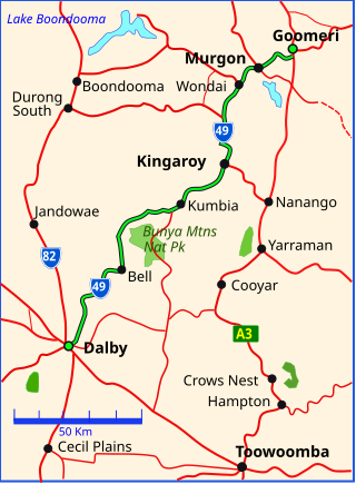
The Bunya Highway is a state highway of Queensland, Australia. It is a relatively short road, running approximately 173 kilometres in a south-westerly direction from Goomeri to Dalby. The highway connects the Warrego and Burnett Highways.

<span class="mw-page-title-main">Shire of Wondai</span> Local government area in Queensland, Australia

The Shire of Wondai was a local government area located in the South Burnett region of Queensland, Australia, about 140 kilometres (87 mi) northwest of the capital, Brisbane. The shire covered an area of 3,577.6 square kilometres (1,381.3 sq mi), and existed as a local government entity from 1910 until 2008, when it amalgamated with several other councils in the South Burnett area to form the South Burnett Region.

<span class="mw-page-title-main">Murgon</span> Town in Queensland, Australia

Murgon is a rural town and locality in the South Burnett Region, Queensland, Australia. In the 2016 census, the locality of Murgon had a population of 2,378 people.

<span class="mw-page-title-main">Wondai</span> Town in Queensland, Australia

Wondai is a rural town and locality in the South Burnett Region, Queensland, Australia. In the 2021 census, Wondai had a population of 1,975 people.

<span class="mw-page-title-main">Goomeri</span> Town in Queensland, Australia

Goomeri is a rural town and locality in the Gympie Region, Queensland, Australia. In the 2016 census, the locality of Goomeri had a population of 664 people.

<span class="mw-page-title-main">South Burnett</span> Region in Queensland, Australia

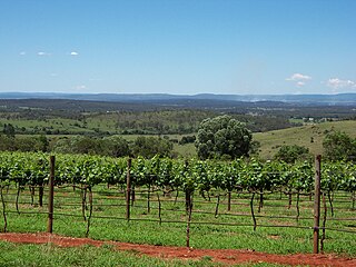
The South Burnett is a peanut growing and wine-producing area on the Great Dividing Range, north of the Darling Downs, in Queensland. It is with the basin of the Burnett River. The area is within two local government areas, South Burnett Region and Gympie Region.

<span class="mw-page-title-main">Tingoora</span> Town in Queensland, Australia

Tingoora is a rural town and a locality in the South Burnett Region, Queensland, Australia.

<span class="mw-page-title-main">Wooroolin, Queensland</span> Town in Queensland, Australia

Wooroolin is a rural town and a locality in the South Burnett Region, Queensland, Australia.

<span class="mw-page-title-main">Nanango railway line</span>

The Nanango railway line was a narrow-gauge branch railway located in Queensland, Australia. On 31 October 1882, parliament approved the construction of a branch line from Theebine west to Kilkivan after gold and copper were discovered in this region of Queensland, Australia. The section was opened in two stages – to Dickabram on 1 January 1886 after two crossings of the Mary River and to Kilkivan on 6 December 1886.

The Kilkivan to Kingaroy Rail Trail is an 88-kilometre (55 mi) recreation trail from Kilkivan to Kingaroy. The trail follows the old Kingaroy Branch railway and is open to walkers, cyclists and horse riders.

<span class="mw-page-title-main">Durong, Queensland</span> Suburb of South Burnett Region, Queensland, Australia

Durong is a rural locality in the South Burnett Region, Queensland, Australia.

Gordonbrook is a rural locality in the South Burnett Region, Queensland, Australia. In the 2016 census Gordonbrook had a population of 175 people.

<span class="mw-page-title-main">Cinnabar, Queensland</span> Suburb of Gympie Region, Queensland, Australia

Cinnabar is a rural locality in the Gympie Region, Queensland, Australia. In the 2016 census, Cinnabar had a population of 72 people.

Corndale is a rural locality in the South Burnett Region, Queensland, Australia.

Kinbombi is a rural town and locality in the Gympie Region, Queensland, Australia. In the 2016 census, the locality of Kinbombi had a population of 37 people.

Leafdale is a rural locality in the South Burnett Region, Queensland, Australia. In the 2016 census, Leafdale had a population of 28 people.

<span class="mw-page-title-main">Mondure</span> Town in Queensland, Australia

Mondure is a rural town and locality in the South Burnett Region, Queensland, Australia. In the 2016 census, Mondure had a population of 100 people.

<span class="mw-page-title-main">Stonelands</span> Suburb of South Burnett Region, Queensland, Australia

Stonelands is a rural locality in the South Burnett Region, Queensland, Australia. In the 2016 census, Stonelands had a population of 51 people.

Chinchilla–Wondai Road is a continuous 151.6 kilometres (94.2 mi) road route in the Western Downs and South Burnett regions of Queensland, Australia. Part of the route is signed as State Route 82. It is a state-controlled part regional and part district road. It provides an alternate route between the Warrego Highway and the South Burnett, bypassing Dalby, Oakey and Toowoomba.

References

  1. Australian Bureau of Statistics (28 June 2022). "Cushnie (Suburb and Locality)". Australian Census 2021 QuickStats. Retrieved 28 June 2022.  OOjs UI icon edit-ltr-progressive.svg
  2. "Cushnie – locality in South Burnett Region (entry 46213)". Queensland Place Names. Queensland Government . Retrieved 16 September 2020.
  3. 1 2 "Queensland Globe". State of Queensland . Retrieved 9 January 2023.
  4. 1 2 3 "Wondai" (Map). Queensland Government. 1943. Retrieved 16 September 2020.
  5. Queensland Family History Society (2010), Queensland schools past and present (Version 1.01 ed.), Queensland Family History Society, ISBN   978-1-921171-26-0
  6. "Agency ID 9055, Home Creek State School". Queensland State Archives . Retrieved 16 September 2020.
  7. "Home Creek – watercourse in the South Burnett Region (entry 16045)". Queensland Place Names. Queensland Government . Retrieved 16 September 2020.
  8. "WONDAI ANXIOUS". The Brisbane Courier . No. 21, 800. Queensland, Australia. 9 December 1927. p. 25. Retrieved 16 September 2020 via National Library of Australia.
  9. "Letters from Little Readers". The Queenslander . Queensland, Australia. 23 June 1932. p. 41. Retrieved 16 September 2020 via National Library of Australia.
  10. "Letters from Little Readers". The Queenslander . Queensland, Australia. 15 September 1932. p. 41. Retrieved 16 September 2020 via National Library of Australia.
  11. Queensland Family History Society (2010), Queensland schools past and present (Version 1.01 ed.), Queensland Family History Society, ISBN   978-1-921171-26-0
  12. "Agency ID 60, Cushnie State School". Queensland State Archives . Retrieved 16 September 2020.
  13. "Queensland Two Mile series sheet 2m79" (Map). Queensland Government. 1955. Archived from the original on 9 January 2023. Retrieved 9 January 2023.
  14. Australian Bureau of Statistics (27 June 2017). "Cushnie (SSC)". 2016 Census QuickStats. Retrieved 20 October 2018. OOjs UI icon edit-ltr-progressive.svg