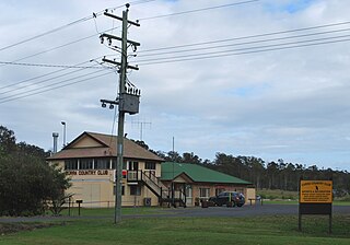
Kilkivan is a town and locality in the Gympie Region of Queensland, Australia. At the 2016 census, Kilkivan had a population of 713.
Tamaree is a rural residential locality in the Gympie Region, Queensland, Australia. In the 2016 census Tamaree had a population of 880 people.

Brooloo is a rural town and locality in the Gympie Region, Queensland, Australia. In the 2016 census, the locality of Brooloo had a population of 348 people.

Theebine is a rural town and locality split between the Gympie Region and the Fraser Coast Region, both in Queensland, Australia.

Gunalda is a rural town in the Gympie Region and a locality split between Gympie Region and Fraser Coast Region in Queensland, Australia. In the 2016 census, the locality of Gunalda had a population of 392 people.

Woolooga is a rural town and locality in the Gympie Region, Queensland, Australia. In the 2016 census the locality of Woolooga had a population of 247 people.

Curra is a rural residential locality in the Gympie Region, Queensland, Australia. In the 2016 census, Curra had a population of 1,920 people.

Tinana is a rural town and locality in the Fraser Coast Region, Queensland, Australia. In the 2016 census the locality of Tinana had a population of 5,476 people.
Lower Wonga is a rural locality in the Gympie Region, Queensland, Australia. In the 2016 census Lower Wonga had a population of 344 people.
O'Bil Bil is a rural locality in the North Burnett Region, Queensland, Australia. In the 2016 census O'Bil Bil had a population of 29 people.
Windera is a town in the South Burnett Region and a locality split between the South Burnett Region and the Gympie Region in Queensland, Australia. In the 2016 census the locality of Windera had a population of 93 people.
Benair is a rural locality in the South Burnett Region, Queensland, Australia. In the 2016 census, Benair had a population of 144 people.
Johnstown is a rural locality split between the South Burnett Region and the Gympie Region, both in Queensland, Australia. In the 2016 census Johnstown had a population of 30 people.
Kanigan is a rural locality split between the Fraser Coast Region and the Gympie Region, both in Queensland, Australia. In the 2016 census Kanigan had a population of 114 people.

Kinbombi is a rural town and locality in the Gympie Region, Queensland, Australia. In the 2016 census, the locality of Kinbombi had a population of 37 people.
Langshaw is a rural locality in the Gympie Region, Queensland, Australia. In the 2016 census Langshaw had a population of 169 people.
Manyung is a rural locality split between the Gympie Region and the South Burnett Region, Queensland, Australia. In the 2016 census Manyung had a population of 63 people.

Tansey is a rural town and locality in the Gympie Region, Queensland, Australia. In the 2016 census, Tansey had a population of 144 people.
Sexton is a rural locality in the Gympie Region, Queensland, Australia. In the 2016 census Sexton had a population of 161 people.
South Nanango is a rural locality in the South Burnett Region, Queensland, Australia. In the 2016 census South Nanango had a population of 858 people.


