Kia Ora, Queensland

Last updated

Map all coordinates using: OpenStreetMap
Kia Ora
Queensland
Kia-Ora State School, 2020.jpg
Kia-Ora State School, 2020
Australia Queensland location map.svg
Red pog.svg
Kia Ora
Coordinates 26°00′56″S152°45′57″E / 26.0155°S 152.7658°E / -26.0155; 152.7658 (Kia Ora (centre of locality))
Population218 (SAL 2021) [1]
Postcode(s) 4570
Area22.5 km2 (8.7 sq mi)
Time zone AEST (UTC+10:00)
Location
LGA(s) Gympie Region
State electorate(s) Gympie
Federal division(s) Wide Bay
Suburbs around Kia Ora:
Neerdie Neerdie Toolara Forest
Neerdie Kia Ora Toolara Forest
Downsfield Goomboorian Toolara Forest

Kia Ora is a rural locality in the Gympie Region, Queensland, Australia. [2] In the 2021 census, Kia Ora had a population of 218 people. [3]

Contents

History

Kia Ora Station homestead, 1931 StateLibQld 1 213652 Kia Ora Station homestead, 1931.jpg
Kia Ora Station homestead, 1931

The district takes its name from the Kia-Ora pastoral property operated by the Elliott family. The name comes from the Māori greeting Kia ora. [4]

Kia-Ora Provisional School opened on 18 July 1921 on land donated by the Elliott family. It became a state school in 1927. [4] [5] [6]

In 1931, the main industries were dairying and forestry. [7]

The Kia Ora Methodist Church opened in September 1938, becoming a Uniting Church folllowing the 1977 amalgamation. [8] [9] It was at 2755 Anderleigh Road ( 26°01′44″S152°46′40″E / 26.02878°S 152.77777°E / -26.02878; 152.77777 (Kia Ora Methodist/Uniting Church) ). It closed circa 1990 and was subsequently sold and converted to a house. [10] [11]

On 9 December 1950, the Kia Ora Memorial Hall was erected to honour those who served in war.. [12]

Demographics

In the 2011 census, Kia Ora had a population of 501 people. [13]

In the 2016 census, Kia Ora had a population of 205 people. [14]

In the 2021 census, Kia Ora had a population of 218 people. [3]

Heritage listings

Kia Ora has the following heritage sites:

Education

Kia-Ora State School is a government primary (Prep-6) school for boys and girls at 2754 Anderleigh Road ( 26°01′42″S152°46′38″E / 26.0284°S 152.7773°E / -26.0284; 152.7773 (Kia-Ora State School) ). [17] [18] In 2017, the school had an enrolment of 62 students with 4 teachers and 11 non-teaching staff (5 full-time equivalent). [19]

There is no secondary school in Kia Ora. The nearest government secondary schools are Gympie State High School (to Year 12) in Gympie to the south-west and Tin Can Bay State School (to Year 10) in Tin Can Bay to the north-east. [20]

Amenities

Kia Ora Public Memorial Hall is at 2740 Anderleigh Road ( 26°01′38″S152°46′38″E / 26.02733°S 152.77724°E / -26.02733; 152.77724 (Kia Ora Memorial Hall) ). [21]

Related Research Articles

<span class="mw-page-title-main">Gympie</span> City in Queensland, Australia

Gympie is a city and a locality in the Gympie Region, Queensland, Australia. In the Wide Bay-Burnett District, Gympie is about 170.7 kilometres (110 mi) north of the state capital, Brisbane. The city lies on the Mary River, which floods Gympie occasionally. The locality of Gympie is the central business district for the city of Gympie and also the administrative centre for the Gympie Region local government area. As of the 2021 Census, Gympie had an urban population of 22,424.

<span class="mw-page-title-main">Landsborough, Queensland</span> Town in Queensland, Australia

Landsborough is a town and a locality in the Sunshine Coast Region, Queensland, Australia. At the 2021 census, Landsborough had a population of 4,446 people.

<span class="mw-page-title-main">Strathpine, Queensland</span> Suburb of City of Moreton Bay, Queensland, Australia

Strathpine is a suburb in the City of Moreton Bay, Queensland, Australia. In the 2016 census, Strathpine had a population of 9,503 people. It is home to the Pine Rivers District offices of the City of Moreton Bay, as well as many businesses. The area is home to Strathpine Centre, a medium-sized urban shopping centre.

Kandanga Creek is a rural locality in the Gympie Region, Queensland, Australia. In the 2016 census, Kandanga Creek had a population of 118 people.

<span class="mw-page-title-main">Eumundi, Queensland</span> Town in Queensland, Australia

Eumundi is a rural town and locality in the Sunshine Coast Region, Queensland, Australia. In the 2021 census, the locality of Eumundi had a population of 2,504 people.

<span class="mw-page-title-main">Kin Kin</span> Suburb of Shire of Noosa, Queensland, Australia

Kin Kin is a rural town and locality in the Shire of Noosa, Queensland, Australia. In the 2016 census, the locality of Kin Kin had a population of 764 people. In the 2021 census the population had risen to 844.

Diddillibah is a semi-rural locality in the Sunshine Coast Region, Queensland, Australia. In the 2016 census, Diddillibah had a population of 1,403 people. In the 2021 census, Diddillibah had a population of 1,703 people.

<span class="mw-page-title-main">Chatsworth, Queensland</span> Suburb of Gympie, Queensland, Australia

Chatsworth is a rural locality in the Gympie Region, Queensland, Australia. In the 2016 census Chatsworth had a population of 1,055 people.

<span class="mw-page-title-main">Glanmire, Queensland</span> Suburb of Gympie, Queensland, Australia

Glanmire is an urban industrial locality in Gympie in the Gympie Region, Queensland, Australia. In the 2021 census, Glanmire had a population of 28 people.

<span class="mw-page-title-main">Brooloo, Queensland</span> Town in Queensland, Australia

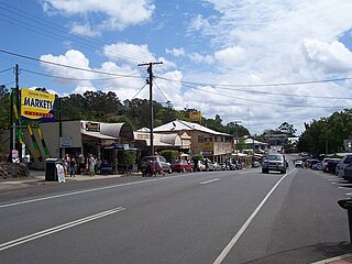
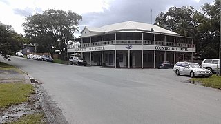
Brooloo is a rural town and locality in the Gympie Region, Queensland, Australia. In the 2016 census, the locality of Brooloo had a population of 348 people.

<span class="mw-page-title-main">Imbil</span> Town in Queensland, Australia

Imbil is a rural town and locality in the Gympie Region, Queensland, Australia. In the 2016 census, Imbil had a population of 924 people.

<span class="mw-page-title-main">Amamoor</span> Town in Queensland, Australia

Amamoor is a rural town and locality in the Gympie Region, Queensland, Australia. In the 2016 census the locality of Amamoor had a population of 636 people.

<span class="mw-page-title-main">Traveston</span> Suburb of Gympie Region, Queensland, Australia

Traveston is a rural town and locality in the Gympie Region, Queensland, Australia. In the 2016 census the locality of Traveston had a population of 480 people.

<span class="mw-page-title-main">Torbanlea</span> Town in Queensland, Australia

Torbanlea is a rural town and locality in the Fraser Coast Region, Queensland, Australia. In the 2016 census the locality of Torbanlea had a population of 791 people.

Cooloola Cove is a coastal locality in the Gympie Region, Queensland, Australia. In the 2021 census, Cooloola Cove had a population of 2,921 people.

Cedar Pocket is a rural locality in the Gympie Region, Queensland, Australia. In the 2016 census Cedar Pocket had a population of 339 people.

Langshaw is a rural locality in the Gympie Region, Queensland, Australia. In the 2016 census Langshaw had a population of 169 people.

Mothar Mountain is a rural locality in the Gympie Region, Queensland, Australia. In the 2016 census Mothar Mountain had a population of 534 people.

Bollier is a rural locality in the Gympie Region, Queensland, Australia. In the 2016 census Bollier had a population of 200 people.

Long Flat is a rural locality in the Gympie Region, Queensland, Australia. In the 2016 census, Long Flat had a population of 80 people.

References

  1. Australian Bureau of Statistics (28 June 2022). "Kia Ora (Qld) (Suburb and Locality)". Australian Census 2021 QuickStats. Retrieved 28 June 2022.  OOjs UI icon edit-ltr-progressive.svg
  2. "Kia Ora – locality in Gympie Region (entry 46347)". Queensland Place Names. Queensland Government . Retrieved 11 June 2019.
  3. 1 2 Australian Bureau of Statistics (28 June 2022). "Kia Ora (SAL)". 2021 Census QuickStats. Retrieved 28 February 2023. OOjs UI icon edit-ltr-progressive.svg
  4. 1 2 "Kia Ora – What's in a name?". Gympie Regional Memories. 29 July 2020. Archived from the original on 31 May 2023. Retrieved 1 October 2023.
  5. "Opening and closing dates of Queensland Schools". Queensland Government . Retrieved 18 April 2019.
  6. "Kia Ora SS". Archived from the original on 2 February 2017. Retrieved 30 January 2017.
  7. "CARAVAN TALES". The Queenslander (Brisbane, Qld. : 1866 - 1939) . Brisbane, Qld.: National Library of Australia. 24 September 1931. p. 4. Archived from the original on 1 October 2023. Retrieved 7 May 2014.
  8. "KIA ORA". The Telegraph . Queensland, Australia. 14 September 1938. p. 12 (CITY FINAL LAST MINUTE NEWS). Archived from the original on 1 October 2023. Retrieved 2 October 2023 via National Library of Australia.
  9. "North Coast Methodist Synod". Nambour Chronicle and North Coast Advertiser . Vol. XXXIII, no. 1795. Queensland, Australia. 28 October 1938. p. 4. Archived from the original on 1 October 2023. Retrieved 2 October 2023 via National Library of Australia.
  10. "Kia Ora Methodist Church | Kia Ora". Queensland Religious Places Database. Archived from the original on 1 October 2023. Retrieved 1 October 2023.
  11. "2755 Anderleigh Road, Kia Ora, QLD 4570". Realestate.com.au . Retrieved 2 October 2023.
  12. "Kia Ora Memorial Hall". Monument Australia. Archived from the original on 7 May 2014. Retrieved 6 May 2014.
  13. Australian Bureau of Statistics (31 October 2012). "Kia Ora (SSC)". 2011 Census QuickStats. Retrieved 6 May 2014. OOjs UI icon edit-ltr-progressive.svg
  14. Australian Bureau of Statistics (27 June 2017). "Kia Ora (SSC)". 2016 Census QuickStats. Retrieved 20 October 2018. OOjs UI icon edit-ltr-progressive.svg
  15. "Kia Ora School". Gympie Regional Council Local Heritage Register. pp. 5–6. Archived from the original on 5 March 2023. Retrieved 2 October 2023.
  16. "Kia Ora Methodist Church". Gympie Regional Council Local Heritage Register. pp. 197–198. Archived from the original on 5 March 2023. Retrieved 2 October 2023.
  17. "State and non-state school details". Queensland Government. 9 July 2018. Archived from the original on 21 November 2018. Retrieved 21 November 2018.
  18. "Kia Ora State School". Kia-Ora State School. 29 November 2020. Archived from the original on 4 May 2013. Retrieved 1 October 2023.
  19. "ACARA School Profile 2017". Archived from the original on 22 November 2018. Retrieved 22 November 2018.
  20. "Layers: Locality; Schools and school catchments". Queensland Globe. Queensland Government. Archived from the original on 19 December 2017. Retrieved 1 October 2023.
  21. "Kia Ora Public Memorial Hall". Gympie Regional Council. Archived from the original on 26 March 2023. Retrieved 1 October 2023.

Commons-logo.svg Media related to Kia Ora, Queensland at Wikimedia Commons