Cooloola, Queensland

Last updated

Cooloola
Queensland
Australia Queensland location map.svg
Red pog.svg
Cooloola
Coordinates 26°02′00″S153°03′50″E / 26.0333°S 153.0638°E / -26.0333; 153.0638 (Cooloola (centre of locality))
Population0 (SAL 2021) [1]
Postcode(s) 4580
Elevation4 m (13 ft)
Area474.5 km2 (183.2 sq mi)
Time zone AEST (UTC+10:00)
Location
LGA(s) Gympie Region
State electorate(s) Gympie
Federal division(s) Wide Bay
Suburbs around Cooloola:
Tin Can Bay Inskip Rainbow Beach
Cooloola Cove Cooloola Coral Sea
Toolara Forest Como Noosa North Shore

Cooloola is a coastal locality in the Gympie Region, Queensland, Australia. [2] In the 2021 census, Cooloola had "no people or a very low population". [3]

Contents

Geography

Cooloola is a coastal locality, being bounded by Wide Bay in the Coral Sea to the east including the major headland, Double Island Point. From Double Island Point, Rainbow Beach extends to the west and then to the north, while Teewah Beach stretches for many kilometres to the south. The locality's north-west boundary is Tin Can Inlet off Tin Can Bay. [4]

Off the coast of Double Island Point is Wolf Rock which is Queensland's most important habitat area for the critically endangered grey nurse shark. It is a mating area and a high number of females and pregnant females have been seen there. [5]

The entire locality is a protected area, mostly within the Great Sandy National Park except for a small area on Double Island Point which is within the Double Island Point Conservation Park. [4] Consistent with its protected status, there is very limited development apart from some basic bushwalking and camping infrastructure. [4]

History

In 1865, William Pettigrew discovered the timber resources of the Cooloola area and established a sawmill and a tramway to harvest the timber. Timber cutting continued in the area until the 1960s when proposals to introduce sand mining and other kinds of development of the area resulted in protests about the environmental damage that it would cause. In 1975, the area was gazetted as the Cooloola National Park (later renamed the Great Sandy National Park). [6]

Demographics

In the 2011 census, Cooloola had a population no people. [7]

In the 2016 census, Cooloola had a population of 3 people. [8]

In the 2021 census, Cooloola had "no people or a very low population". [3]

Heritage listings

Cooloola has a number of heritage-listed sites, including:

Attractions

The Cooloola Great Walk is a 5-day walking track through Cooloola through to Rainbow Beach (to the north) and Noosa North Shore to the south. [10] [11] [12]

See also

Related Research Articles

<span class="mw-page-title-main">Esk, Queensland</span> Town in Queensland, Australia

Esk is a rural town and locality in the Somerset Region in South East Queensland, Australia. In the 2021 census, the locality of Esk had a population of 1,641 people.

<span class="mw-page-title-main">Palmwoods, Queensland</span> Town in Queensland, Australia

Palmwoods is a rural town and locality in the Sunshine Coast Region, Queensland, Australia. In the 2021 census, the locality of Palmwoods had a population of 6,357 people.

<span class="mw-page-title-main">Tewantin</span> Suburb of Shire of Noosa, Queensland, Australia

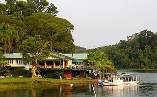
Tewantin is a town and locality in the Shire of Noosa, Queensland, Australia. Tewantin was the original settlement in the Noosa region and is one of its three major centres today. In the 2021 census, the locality of Tewantin had a population of 11,164 people.

<span class="mw-page-title-main">Fitzroy Island (Queensland)</span> Suburb of Cairns Region, Queensland, Australia.

Fitzroy Island is a continental island offshore from Cape Grafton, 29 km southeast of Cairns, Queensland, Australia. It is a locality in the Cairns Region. In the 2021 census, Fitzroy Island had a population of 85 people.

<span class="mw-page-title-main">Rainbow Beach, Queensland</span> Town in Queensland, Australia

Rainbow Beach is a coastal rural town and locality in the Gympie Region, Queensland, Australia. In the 2016 census, Rainbow Beach had a population of 1,249 people.

<span class="mw-page-title-main">Noosa North Shore, Queensland</span> Suburb of Noosa, Queensland, Australia

Noosa North Shore is a coastal rural locality in the Shire of Noosa, Queensland, Australia. In the 2021 census, Noosa North Shore had a population of 253 people.

<span class="mw-page-title-main">Como, Queensland</span> Suburb of Sunshine Coast, Queensland, Australia

Como is a rural locality in the Shire of Noosa, Queensland, Australia. In the 2021 census, Como had a population of 54 people.

<span class="mw-page-title-main">Tin Can Bay, Queensland</span> Town in Queensland, Australia

Tin Can Bay is a coastal town and locality in the Wide Bay–Burnett region in Queensland, Australia. The locality is split between the Fraser Coast Region and the Gympie Region, but the town itself is within Gympie Region. In the 2016 census, Tin Can Bay had a population of 2,242 people.

Kybong is a rural locality in the Gympie Region, Queensland, Australia. In the 2021 census, Kybong had a population of 363 people.

<span class="mw-page-title-main">Geham</span> Suburb of Toowoomba Region, Queensland, Australia

Geham is a rural locality in the Toowoomba Region, Queensland, Australia. In the 2021 census, Geham had a population of 470 people.

<span class="mw-page-title-main">Southern Moreton Bay Islands, Queensland</span> Suburb of Gold Coast, Queensland, Australia

Southern Moreton Bay Islands is an island group locality in the north-east of the City of Gold Coast, Queensland, Australia. In the 2021 census, Southern Moreton Bay Islands had no people.

Cooloola Cove is a coastal locality in the Gympie Region, Queensland, Australia. In the 2021 census, Cooloola Cove had a population of 2,921 people.

<span class="mw-page-title-main">Cooloola Tramway</span> Historic site in Queensland, Australia

The Cooloola Tramway is a heritage-listed tramway at Great Sandy National Park, Cooloola Recreation Area, Cooloola, Gympie Region, Queensland, Australia. In the 1870s it was known as the Kaloola Railway. It is also known as Cooloola Railway, SEQ-5N 22, Pettigrew's Railway, and Pettigrew's Tramway. It was added to the Queensland Heritage Register on 12 July 2013.

<span class="mw-page-title-main">Qunaba, Queensland</span> Suburb of Bundaberg Region, Queensland, Australia

Qunaba is a rural locality in the Bundaberg Region, Queensland, Australia. In the 2016 census Qunaba had a population of 793 people.

Bunya Mountains is a locality split between the Western Downs Region and the South Burnett Region, Queensland, Australia. The town of Mount Mowbullan is located on the boundary of Bunya Mountains and the enclosed locality of Mowbullan. In the 2016 census, Bunya Mountains had a population of 144 people.

<span class="mw-page-title-main">Fairymead, Queensland</span> Suburb of Bundaberg Region, Queensland, Australia

Fairymead is a coastal locality in the Bundaberg Region, Queensland, Australia. In the 2021 census, Fairymead had a population of 28 people.

<span class="mw-page-title-main">Lake Barrine, Queensland</span> Suburb of Tablelands Region, Queensland, Australia

Lake Barrine is a rural locality in the Tablelands Region, Queensland, Australia. In the 2021 census, Lake Barrine had a population of 170 people.

Tinnanbar is a coastal town and a locality in the Fraser Coast Region, Queensland, Australia. In the 2016 census, Tinnanbar had a population of 123 people.

Germantown is a rural locality in the Cassowary Coast Region, Queensland, Australia. In the 2021 census, Germantown had a population of 52 people.

References

  1. Australian Bureau of Statistics (28 June 2022). "Cooloola (Suburb and Locality)". Australian Census 2021 QuickStats. Retrieved 28 June 2022.  OOjs UI icon edit-ltr-progressive.svg
  2. "Cooloola – locality (entry 47613)". Queensland Place Names. Queensland Government . Retrieved 31 October 2015.
  3. 1 2 Australian Bureau of Statistics (28 June 2022). "Cooloola (SAL)". 2021 Census QuickStats. Retrieved 28 February 2023. OOjs UI icon edit-ltr-progressive.svg
  4. 1 2 3 "Queensland Globe". State of Queensland . Retrieved 1 September 2023.
  5. "Grey nurse shark". www.ehp.qld.gov.au. Queensland Government. Archived from the original on 29 October 2015. Retrieved 31 October 2015.
  6. 1 2 "Pettigrew's Cooloola Timber Tramway Complex (entry 602819)". Queensland Heritage Register . Queensland Heritage Council. Retrieved 1 August 2014.
  7. Australian Bureau of Statistics (31 October 2012). "Cooloola". 2011 Census QuickStats. Retrieved 31 October 2015. OOjs UI icon edit-ltr-progressive.svg
  8. Australian Bureau of Statistics (27 June 2017). "Cooloola (SSC)". 2016 Census QuickStats. Retrieved 20 October 2018. OOjs UI icon edit-ltr-progressive.svg
  9. "Double Island Point Lightstation (entry 601722)". Queensland Heritage Register . Queensland Heritage Council. Retrieved 8 July 2013.
  10. "Cooloola Great Walk". www.nprsr.qld.gov.au. Queensland Government. Archived from the original on 20 December 2015. Retrieved 31 October 2015.
  11. "Cooloola Great Walk". Parks and forests. Queensland Government. 12 March 2010. Archived from the original on 30 June 2023. Retrieved 31 August 2023.
  12. "About | Cooloola Great Walk". Parks and forests. Queensland Government. 12 March 2010. Archived from the original on 7 June 2023. Retrieved 31 August 2023.