Como, Queensland

Last updated

Map all coordinates using: OpenStreetMap
Como
Sunshine Coast,  Queensland
Harry's Hut Kayaks - panoramio.jpg
Kayaks on the Noosa River at Harry's Hut, 2011
Australia Queensland location map.svg
Red pog.svg
Como
Coordinates 26°14′54″S153°00′34″E / 26.2483°S 153.0094°E / -26.2483; 153.0094 (Como (centre of locality))
Population54 (SAL 2021) [1]
Postcode(s) 4571
Elevation20 m (66 ft)
Area103.8 km2 (40.1 sq mi)
Time zone AEST (UTC+10:00)
Location
LGA(s) Shire of Noosa
State electorate(s) Noosa
Federal division(s) Wide Bay
Suburbs around Como:
Toolara Forest Cooloola Cooloola
Coondoo Como Noosa North Shore
Kin Kin Cootharaba Noosa North Shore

Como is a rural locality in the Shire of Noosa, Queensland, Australia. [2] In the 2021 census, Como had a population of 54 people. [3]

Contents

Geography

Como is on the Sunshine Coast, 47.8 kilometres (30 mi) north-west of Noosa Heads, [4] immediately south of the boundary between the Shire of Noosa and Gympie Region (to the north). [5]

The locality is bordered to the north-east and east by the Noosa River and to the south-east by the shore of Lake Cootharaba. [5]

Much of the locality is within protected areas. Most of the east of the locality is within the Great Sandy National Park with part of the west of the locality within the Toolara State Forest. [5] The south-west of the locality has rural residential land and is also used for grazing and crop-growing. The north of the locality also has grazing. [5]

History

Historically, this area has been logged for timber, resulting in a number of campsites and small townships established for the timber workers. Transport of the timber and workers was mostly by boat. [6]

Harry's Hut was built in 1957 as a shelter for timber workers from a local campsite to use during heavy rainfall. After the logging ceased in the 1960s, the hut was purchased by Harry Spring who operated pharmacies in Pomona and Cooroy. He used the hut as a base while fishing in the Noosa River. Following his death in 1999, the hut came under the control of the National Parks department of the Queensland Government, but it continues to bear his name. [7]

Between 2008 and 2013, Como was within Sunshine Coast Region. In 2008, the Queensland Government forced Shire of Noosa to amalgamate, resulting in the new local government area of Sunshine Coast Region. However, a vote of former Shire of Noosa residents was taken to de-amalgamate, and Shire of Noosa was re-established in 2014. [8] [9]

Heritage listings

Harry's Hut, 2011 Harry's Hut - panoramio.jpg
Harry's Hut, 2011

Como has a number of heritage-listed sites, including:

Demographics

In the 2016 census, Como had a population of 46 people. [11]

In the 2021 census, Como had a population of 54 people. [3]

Economy

There are a number of homesteads in the locality: [12]

Education

There are no schools in Como. The nearest government primary school is Kin Kin State School in neighbouring Kin Kin to the south-west. The nearest government secondary school is Noosa District State High School which has its junior campus in Pomona to the south-west and its senior campus in Cooroy to the south. [5]

Attractions

Harry's Hut recreational area is a day-use and camping area on the shores of the Noosa River in the Great Sandy National Park. These facilities are at the northern end of Harrys Hut Road. [13] [14] [15]

See also

Related Research Articles

<span class="mw-page-title-main">Peregian Beach</span> Town in Queensland, Australia

Peregian Beach is a beach and small coastal town on the Sunshine Coast, Queensland, Australia. It is a suburb split between two local government areas with the eastern coastal in the Shire of Noosa and the western hinterland part in the Sunshine Coast Region. In the 2021 census, the suburb of Peregian Beach had a population of 4,972 people.

<span class="mw-page-title-main">Noosa Heads, Queensland</span> Town in Queensland, Australia

Noosa Heads is a coastal town and suburb in the Shire of Noosa, Queensland, Australia. In the 2016 census, the suburb of Noosa Heads had a population of 4,484 people. It is a popular holiday destination.

<span class="mw-page-title-main">Shire of Noosa</span> Local government area in Queensland, Australia

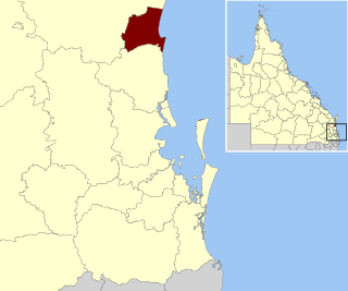
The Shire of Noosa is a local government area about 130 kilometres (81 mi) north of Brisbane in the Sunshine Coast district of South East Queensland, Australia. The shire covers an area of 870 square kilometres (335.9 sq mi). It existed as a local government entity from 1910 until 2008, when it was amalgamated with the Shire of Maroochy and City of Caloundra to form the Sunshine Coast Region. The shire was re-established on 1 January 2014. In the 2021 census, the shire had a population of 56,298 people.

<span class="mw-page-title-main">Tewantin</span> Suburb of Shire of Noosa, Queensland, Australia

Tewantin is a town and locality in the Shire of Noosa, Queensland, Australia. Tewantin was the original settlement in the Noosa region and is one of its three major centres today. In the 2021 census, the locality of Tewantin had a population of 11,164 people.

<span class="mw-page-title-main">Pomona, Queensland</span> Town in Queensland, Australia

Pomona is a rural town and locality in the Shire of Noosa, Queensland, Australia. In the 2016 census the locality of Pomona had a population of 2,910 people. Pomona is located around 135 kilometres north of Brisbane. It is located at the base of Mount Cooroora at the northern end of the Sunshine Coast.

<span class="mw-page-title-main">Boreen Point, Queensland</span> Suburb of Noosa, Queensland, Australia

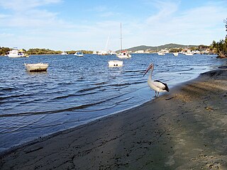
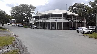
Boreen Point is a rural locality in the Shire of Noosa, Queensland, Australia. In the 2016 census, Boreen Point had a population of 328 people. The town of Boreen is located within the locality beside the lake, but the town name is rarely used with Boreen Point being the name in common usage.

<span class="mw-page-title-main">Lake Cootharaba</span> Lake in Queensland, Australia

Lake Cootharaba is a lake on the Noosa River within the locality of Noosa North Shore in the Shire of Noosa, Queensland, Australia. It is the gateway to the Everglades, a popular tourist attraction for Noosa, being 20 km away from Noosa. The lake's major access is the town of Boreen Point, as well as the smaller camping-spot of Elanda Point.

<span class="mw-page-title-main">Cooran, Queensland</span> Town in Queensland, Australia

Cooran is a rural hinterland town and locality in the Shire of Noosa, Queensland, Australia. In the 2016 census the locality of Cooran had a population of 1,624 people.

<span class="mw-page-title-main">Kin Kin</span> Suburb of Shire of Noosa, Queensland, Australia

Kin Kin is a rural town and locality in the Shire of Noosa, Queensland, Australia. In the 2016 census, the locality of Kin Kin had a population of 764 people. In the 2021 census the population had risen to 844.

Doonan is a rural residential locality split between the Sunshine Coast Region and the Shire of Noosa, both in Queensland, Australia. In the 2016 census, Doonan had a population of 3,459 people.

<span class="mw-page-title-main">Lake Macdonald, Queensland</span> Suburb of Sunshine Coast, Queensland, Australia

Lake Macdonald is a rural locality in the Shire of Noosa, Queensland, Australia. In the 2016 census Lake Macdonald had a population of 1,363 people.

<span class="mw-page-title-main">Tinbeerwah, Queensland</span> Suburb of Shire of Noosa, Queensland, Australia

Tinbeerwah is a semi-rural locality in the Shire of Noosa, Queensland, Australia. In the 2021 census, Tinbeerwah had a population of 1,160 people.

Federal is a rural locality in the Shire of Noosa, Queensland, Australia. It is located in the Sunshine Coast hinterland near the towns of Cooran and Pomona. In the 2021 census, Federal had a population of 365 people.

Ridgewood is a rural locality in the Shire of Noosa, Queensland, Australia. In the 2021 census, Ridgewood had a population of 317 people.

Black Mountain is a rural locality in the Shire of Noosa, Queensland, Australia. In the 2016 census, Black Mountain had a population of 1,444 people.

Ringtail Creek is a rural locality in the Shire of Noosa, Queensland, Australia. In the 2016 census Ringtail Creek had a population of 197 people.

Cootharaba is a rural locality in the Shire of Noosa, Queensland, Australia. In the 2021 census, Cootharaba had a population of 866 people.

Cooroy Mountain is a rural locality in the Shire of Noosa, Queensland, Australia. In the 2021 census, Cooroy Mountain had a population of 148 people.

Kybong is a rural locality in the Gympie Region, Queensland, Australia. In the 2021 census, Kybong had a population of 363 people.

<span class="mw-page-title-main">Noosa River</span> River in Queensland, Australia

The Noosa River is a river situated in South East Queensland. The catchment starts in the Como Escarpment near Mount Elliott in the coastal Great Sandy National Park and meanders south through a lakes district around Tewantin.

References

  1. Australian Bureau of Statistics (28 June 2022). "Como (Qld) (Suburb and Locality)". Australian Census 2021 QuickStats. Retrieved 28 June 2022.  OOjs UI icon edit-ltr-progressive.svg
  2. "Como – locality in Shire of Noosa (entry 48574)". Queensland Place Names. Queensland Government . Retrieved 5 November 2019.
  3. 1 2 Australian Bureau of Statistics (28 June 2022). "Como (SAL)". 2021 Census QuickStats. Retrieved 28 February 2023. OOjs UI icon edit-ltr-progressive.svg
  4. Google (7 August 2023). "Noosa Heads to Como" (Map). Google Maps . Google. Retrieved 7 August 2023.
  5. 1 2 3 4 5 "Queensland Globe". State of Queensland . Retrieved 7 August 2023.
  6. 1 2 "Mill Point Settlement Site (entry 601280)". Queensland Heritage Register . Queensland Heritage Council. Retrieved 14 July 2013.
  7. 1 2 "Historical cultural heritage of Noosa Shire: Boreen Point, Kin Kin & Cootharaba". Noosa Shire Council . pp. 13–15. Archived from the original on 2 August 2023. Retrieved 7 August 2023.
  8. "Backward Glance: History of Local Government on the Sunshine Coast". Sunshine Coast Regional Council . Archived from the original on 2 August 2023. Retrieved 2 August 2023.
  9. "The Noosa De-amalgamation: Building a New Organisation". Noosa Shire Council . 2 January 2014. pp. 8–9. Archived from the original on 6 April 2023. Retrieved 2 August 2023.
  10. "Historical cultural heritage of Noosa Shire: Boreen Point, Kin Kin & Cootharaba". Noosa Shire Council . pp. 9–12. Archived from the original on 2 August 2023. Retrieved 7 August 2023.
  11. Australian Bureau of Statistics (27 June 2017). "Como (SSC)". 2016 Census QuickStats. Retrieved 20 October 2018. OOjs UI icon edit-ltr-progressive.svg
  12. "Homesteads - Queensland". Queensland Open Data. Queensland Government. 18 November 2020. Archived from the original on 24 November 2020. Retrieved 24 November 2020.
  13. "Harrys day-use area | Cooloola Recreation Area, Great Sandy National Park". Parks and forests. Queensland Government. 21 April 2017. Archived from the original on 1 June 2023. Retrieved 7 August 2023.
  14. "Harrys (river access) camping area | Cooloola Recreation Area, Great Sandy National Park". Parks and forests. Queensland Government. 24 January 2018. Archived from the original on 1 June 2023. Retrieved 7 August 2023.
  15. "Harrys camping and day-use area map" (PDF). Parks and forests. Queensland Government. March 2021. Archived (PDF) from the original on 10 March 2023. Retrieved 7 August 2023.