Cooroy Mountain, Queensland

Last updated

Cooroy Mountain
Queensland
Australia Queensland location map.svg
Red pog.svg
Cooroy Mountain
Coordinates 26°25′55″S152°57′04″E / 26.4319°S 152.9511°E / -26.4319; 152.9511 (Cooroy Mountain (centre of locality))
Population148 (SAL 2021) [1]
Postcode(s) 4563
Elevation100–422 m (328–1,385 ft) [2]
Area9.2 km2 (3.6 sq mi)
Time zone AEST (UTC+10:00)
Location
LGA(s) Shire of Noosa
State electorate(s) Noosa
Federal division(s) Wide Bay
Suburbs around Cooroy Mountain:
Lake MacDonald Lake MacDonald Tinbeerwah
Cooroy Cooroy Mountain Tinbeerwah
Eerwah Vale Eumundi Doonan

Cooroy Mountain is a rural locality in the Shire of Noosa, Queensland, Australia. [3] In the 2021 census, Cooroy Mountain had a population of 148 people. [4]

Contents

Geography

Mount Cooroy is in the south-east of the locality ( 26°25′57″S152°57′12″E / 26.4325°S 152.9533°E / -26.4325; 152.9533 (Mount Cooroy) ) and rises to 422 metres (1,385 ft) above sea level. [5] [6] It is within the Mount Cooroy Conservation Park. [2]

Apart from the protected area, the remainder of the locality is used for a mix of rural residential housing and grazing on native vegetation. [2]

History

Cooroy Mountain's name came from Mount Cooroy, which was originally called Coorooey, from the Aboriginal word for possum, kurui. [7]

Kuri'bigil'ba is the name of Cooroy Mountain in the dialect of the Kabi speaking aboriginal peoples of this area. It means the place where the Sun God came down to Dha (Earth). It is believed the mountain turned yellow once a year due to the flowering of an unknown tree. [8] Most likely due to the endemic silky oak tree ( Grevillea robusta ) which has glabrous yellowish orange flowers from around September to November.

The Kabi Kabi people are the traditional owners of the land. While the Kabi people and their language group are not extinct, many are no longer in the local area of Cooroy mountain as a result of having been moved out of the area as a result of government policies in the past. [9] [10]

Between 2008 and 2013, Cooroy Mountain (and the rest of the Shire of Noosa) was within Sunshine Coast Region, due to an enforced amalgamation of local government areas that was subsequently reversed. [11] [12]

Demographics

In the 2016 census, Cooroy Mountain had a population of 136 people. [13]

In the 2021 census, Cooroy Mountain had a population of 148 people. [4]

Education

There are no schools in Cooroy Mountain. The nearest government primary schools are Cooroy State School in neighbouring Cooroy to the west and Eumundi State School in neighbouring Eumundi to the south. The nearest government secondary school is the Noosa District State High School, which has its junior campus in Pomona to the north-west and its senior campus in neighbouring Cooroy to the west. [2]

Related Research Articles

<span class="mw-page-title-main">Sunshine Coast, Queensland</span> Region in Queensland, Australia

The Sunshine Coast is a peri-urban region in South East Queensland, Australia. It is the district defined in 1967 as "the area contained in the Shires of Landsborough, Maroochy and Noosa, but excluding Bribie Island". Located 100 km (62 mi) north of the centre of Brisbane in South East Queensland, on the Coral Sea coastline, its urban area spans approximately 60 km (37 mi) of coastline and hinterland from Pelican Waters to Tewantin.

<span class="mw-page-title-main">Peregian Beach</span> Town in Queensland, Australia

Peregian Beach is a beach and small coastal town on the Sunshine Coast, Queensland, Australia. It is a suburb split between two local government areas with the eastern coastal in the Shire of Noosa and the western hinterland part in the Sunshine Coast Region. In the 2021 census, the suburb of Peregian Beach had a population of 4,972 people.

<span class="mw-page-title-main">Noosa Heads, Queensland</span> Town in Queensland, Australia

Noosa Heads is a coastal town and suburb in the Shire of Noosa, Queensland, Australia. In the 2016 census, the suburb of Noosa Heads had a population of 4,484 people. It is a popular holiday destination.

<span class="mw-page-title-main">Cooroy, Queensland</span> Town in Queensland, Australia

Cooroy is a rural town and locality in the Shire of Noosa, Queensland, Australia. In the 2016 census the locality of Cooroy had a population of 3,791 people.

<span class="mw-page-title-main">Shire of Noosa</span> Local government area in Queensland, Australia

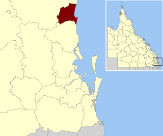
The Shire of Noosa is a local government area about 130 kilometres (81 mi) north of Brisbane in the Sunshine Coast district of South East Queensland, Australia. The shire covers an area of 870 square kilometres (335.9 sq mi). It existed as a local government entity from 1910 until 2008, when it was amalgamated with the Shire of Maroochy and City of Caloundra to form the Sunshine Coast Region. The shire was re-established on 1 January 2014. In the 2021 census, the shire had a population of 56,298 people.

<span class="mw-page-title-main">Pomona, Queensland</span> Town in Queensland, Australia

Pomona is a rural town and locality in the Shire of Noosa, Queensland, Australia. In the 2016 census the locality of Pomona had a population of 2,910 people. Pomona is located around 135 kilometres north of Brisbane. It is located at the base of Mount Cooroora at the northern end of the Sunshine Coast.

<span class="mw-page-title-main">Eumundi, Queensland</span> Town in Queensland, Australia

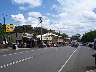
Eumundi is a rural town and locality in the Sunshine Coast Region, Queensland, Australia. In the 2021 census, the locality of Eumundi had a population of 2,504 people.

<span class="mw-page-title-main">Cooran, Queensland</span> Town in Queensland, Australia

Cooran is a rural hinterland town and locality in the Shire of Noosa, Queensland, Australia. In the 2016 census the locality of Cooran had a population of 1,624 people.

Doonan is a rural residential locality split between the Sunshine Coast Region and the Shire of Noosa, both in Queensland, Australia. In the 2016 census, Doonan had a population of 3,459 people.

<span class="mw-page-title-main">Lake Macdonald, Queensland</span> Suburb of Sunshine Coast, Queensland, Australia

Lake Macdonald is a rural locality in the Shire of Noosa, Queensland, Australia. In the 2016 census Lake Macdonald had a population of 1,363 people.

<span class="mw-page-title-main">Tinbeerwah, Queensland</span> Suburb of Shire of Noosa, Queensland, Australia

Tinbeerwah is a semi-rural locality in the Shire of Noosa, Queensland, Australia. In the 2016 census, Tinbeerwah had a population of 974 people.

Federal is a rural locality in the Shire of Noosa, Queensland, Australia. It is located in the Sunshine Coast hinterland near the towns of Cooran and Pomona. In the 2021 census, Federal had a population of 365 people.

Ridgewood is a rural locality in the Shire of Noosa, Queensland, Australia. In the 2016 census, Ridgewood had a population of 307 people.

Black Mountain is a rural locality in the Shire of Noosa, Queensland, Australia. In the 2016 census, Black Mountain had a population of 1,444 people.

Ringtail Creek is a rural locality in the Shire of Noosa, Queensland, Australia. In the 2016 census Ringtail Creek had a population of 197 people.

Cootharaba is a rural locality in the Shire of Noosa, Queensland, Australia. In the 2021 census, Cootharaba had a population of 866 people.

<span class="mw-page-title-main">Como, Queensland</span> Suburb of Sunshine Coast, Queensland, Australia

Como is a rural locality in the Shire of Noosa, Queensland, Australia. In the 2021 census, Como had a population of 54 people.

<span class="mw-page-title-main">Eerwah Vale, Queensland</span> Suburb of Sunshine Coast, Queensland, Australia

Eerwah Vale is a locality split between the Sunshine Coast Region and Shire of Noosa, both in Queensland, Australia. In the 2016 census Eerwah Vale had a population of 621 people.

<span class="mw-page-title-main">Sunshine Coast Region</span> Local government area in Queensland, Australia

The Sunshine Coast Region is a local government area located in the Sunshine Coast region of South East Queensland, Australia.

Mount Mellum is a rural locality in the Sunshine Coast Region, Queensland, Australia. In the 2016 census, Mount Mellum had a population of 442 people.

References

  1. Australian Bureau of Statistics (28 June 2022). "Cooroy Mountain (Suburb and Locality)". Australian Census 2021 QuickStats. Retrieved 28 June 2022.  OOjs UI icon edit-ltr-progressive.svg
  2. 1 2 3 4 "Queensland Globe". State of Queensland . Retrieved 8 August 2023.
  3. "Cooroy Mountain – locality in Shire of Noosa (entry 48585)". Queensland Place Names. Queensland Government . Retrieved 5 November 2019.
  4. 1 2 Australian Bureau of Statistics (28 June 2022). "Cooroy Mountain (SAL)". 2021 Census QuickStats. Retrieved 28 February 2023. OOjs UI icon edit-ltr-progressive.svg
  5. "Mountain peaks and capes - Queensland". Queensland Open Data. Queensland Government. 12 November 2020. Archived from the original on 25 November 2020. Retrieved 25 November 2020.
  6. "Mount Cooroy – mountain in Noosa Shire (entry 8321)". Queensland Place Names. Queensland Government . Retrieved 25 November 2020.
  7. South East Queensland - Place Names Archived 22 June 2005 at the Wayback Machine 16 December 2006
  8. Tales of a Warrior series of books by Brett Green, Gympie
  9. "Gubbi Gubbi (Kabi Kabi)". gubbigubbi.com. Archived from the original on 31 March 2016. Retrieved 14 November 2019.
  10. "Gubbi Gubbi". Archived from the original on 17 May 2014. Retrieved 17 May 2014.
  11. "Backward Glance: History of Local Government on the Sunshine Coast". Sunshine Coast Regional Council . Archived from the original on 2 August 2023. Retrieved 2 August 2023.
  12. "The Noosa De-amalgamation: Building a New Organisation". Noosa Shire Council . 2 January 2014. pp. 8–9. Archived from the original on 6 April 2023. Retrieved 2 August 2023.
  13. Australian Bureau of Statistics (27 June 2017). "Cooroy Mountain (SSC)". 2016 Census QuickStats. Retrieved 20 October 2018. OOjs UI icon edit-ltr-progressive.svg