Ridgewood, Queensland

Last updated

Ridgewood
Queensland
Australia Queensland location map.svg
Red pog.svg
Ridgewood
Coordinates 26°27′40″S152°50′01″E / 26.4611°S 152.8336°E / -26.4611; 152.8336 (Ridgewood (centre of locality))
Population317 (SAL 2021) [1]
Postcode(s) 4563
Area38.9 km2 (15.0 sq mi)
Time zone AEST (UTC+10:00)
Location
LGA(s) Shire of Noosa
State electorate(s) Nicklin
Federal division(s) Wide Bay
Suburbs around Ridgewood:
Tuchekoi
Federal
Black Mountain Black Mountain
Carters Ridge Ridgewood Cooroy
Belli Park Belli Park Belli Park

Ridgewood is a rural locality in the Shire of Noosa, Queensland, Australia. [2] In the 2021 census, Ridgewood had a population of 317 people. [3]

Contents

Geography

Ridgewood is in the Sunshine Coast hinterland about 32 kilometres (20 mi) west of Noosa Heads.

History

Mary River Road Provisional School opened in 1916. Circa 1918, it was renamed Ridgewood State School. It closed circa 1961. [4] It was on Cooroy Belli Creek Road (approx 26°27′12″S152°49′30″E / 26.4532°S 152.8251°E / -26.4532; 152.8251 (Ridgewood State School (former)) ). [5] [6]

Between 2008 and 2013, Ridgewood (and the rest of the Shire of Noosa) was within Sunshine Coast Region due to an unpopular local government amalgamation that was subsequently reversed. [7] [8] [9]

Demographics

In the 2006 census, Ridgewood had a population of 612 people. [10]

In the 2016 census, Ridgewood had a population of 307 people. [11]

In the 2021 census, Ridgewood had a population of 317 people. [3]

Education

There are no schools in Ridgewood. The nearest government primary schools are Cooroy State School in neighbouring Cooroy to the north-east, Federal State School in neighbouring Federal to the north-west, and Eumundi State School in Eumundi to the east. The nearest government secondary school is Noosa District State High School which has its junior campus in Pomona to the north and its senior campus in Cooroy. [12]

Related Research Articles

<span class="mw-page-title-main">Cooroy, Queensland</span> Town in Queensland, Australia

Cooroy is a rural town and locality in the Shire of Noosa, Queensland, Australia. In the 2016 census the locality of Cooroy had a population of 3,791 people.

<span class="mw-page-title-main">Tewantin</span> Suburb of Shire of Noosa, Queensland, Australia

Tewantin is a rural town and locality in the Shire of Noosa, Queensland, Australia. In the 2016 census, Tewantin had a population of 10,920 people. Tewantin was the original settlement in the Noosa region and is one of its three major centres today.

<span class="mw-page-title-main">Pomona, Queensland</span> Town in Queensland, Australia

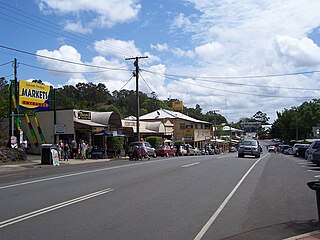
Pomona is a rural town and locality in the Shire of Noosa, Queensland, Australia. In the 2016 census the locality of Pomona had a population of 2,910 people. Pomona is located around 135 kilometres north of Brisbane. It is located at the base of Mount Cooroora at the northern end of the Sunshine Coast.

<span class="mw-page-title-main">Boreen Point, Queensland</span> Suburb of Noosa, Queensland, Australia

Boreen Point is a rural locality in the Shire of Noosa, Queensland, Australia. In the 2016 census, Boreen Point had a population of 328 people. The town of Boreen is located within the locality beside the lake, but the town name is rarely used with Boreen Point being the name in common usage.

<span class="mw-page-title-main">Eumundi, Queensland</span> Town in Queensland, Australia

Eumundi is a rural town and locality in the Sunshine Coast Region, Queensland, Australia. In the 2021 census, the locality of Eumundi had a population of 2,504 people.

<span class="mw-page-title-main">Cooran, Queensland</span> Town in Queensland, Australia

Cooran is a rural hinterland town and locality in the Shire of Noosa, Queensland, Australia. In the 2016 census the locality of Cooran had a population of 1,624 people.

Doonan is a rural residential locality split between the Sunshine Coast Region and the Shire of Noosa, both in Queensland, Australia. In the 2016 census, Doonan had a population of 3,459 people.

<span class="mw-page-title-main">Lake Macdonald, Queensland</span> Suburb of Sunshine Coast, Queensland, Australia

Lake Macdonald is a rural locality in the Shire of Noosa, Queensland, Australia. In the 2016 census Lake Macdonald had a population of 1,363 people.

<span class="mw-page-title-main">Cooroibah, Queensland</span> Suburb of Noosa, Queensland, Australia

Cooroibah is a locality in the Shire of Noosa, Queensland, Australia. In the 2021 census, Cooroibah had a population of 2,178 people.

<span class="mw-page-title-main">Tinbeerwah, Queensland</span> Suburb of Shire of Noosa, Queensland, Australia

Tinbeerwah is a semi-rural locality in the Shire of Noosa, Queensland, Australia. In the 2016 census, Tinbeerwah had a population of 974 people.

<span class="mw-page-title-main">Noosa North Shore, Queensland</span> Suburb of Noosa, Queensland, Australia

Noosa North Shore is a coastal rural locality in the Shire of Noosa, Queensland, Australia. In the 2021 census, Noosa North Shore had a population of 253 people.

Federal is a rural locality in the Shire of Noosa, Queensland, Australia. It is located in the Sunshine Coast hinterland near the towns of Cooran and Pomona. In the 2021 census, Federal had a population of 365 people.

Black Mountain is a rural locality in the Shire of Noosa, Queensland, Australia. In the 2016 census, Black Mountain had a population of 1,444 people.

<span class="mw-page-title-main">Pinbarren, Queensland</span> Suburb of Sunshine Coast, Queensland, Australia

Pinbarren is a rural town and locality in the Shire of Noosa, Queensland, Australia. In the 2021 census, the locality of Pinbarren had a population of 447 people.

Ringtail Creek is a rural locality in the Shire of Noosa, Queensland, Australia. In the 2016 census Ringtail Creek had a population of 197 people.

Cootharaba is a rural locality in the Shire of Noosa, Queensland, Australia. In the 2021 census, Cootharaba had a population of 866 people.

Cooroy Mountain is a rural locality in the Shire of Noosa, Queensland, Australia. In the 2021 census, Cooroy Mountain had a population of 148 people.

<span class="mw-page-title-main">Como, Queensland</span> Suburb of Sunshine Coast, Queensland, Australia

Como is a rural locality in the Shire of Noosa, Queensland, Australia. In the 2021 census, Como had a population of 54 people.

Verrierdale is a rural locality in the Sunshine Coast Region, Queensland, Australia. In the 2016 census, Verrierdale had a population of 775 people.

<span class="mw-page-title-main">Eerwah Vale, Queensland</span> Suburb of Sunshine Coast, Queensland, Australia

Eerwah Vale is a locality split between the Sunshine Coast Region and Shire of Noosa, both in Queensland, Australia. In the 2016 census Eerwah Vale had a population of 621 people.

References

  1. Australian Bureau of Statistics (28 June 2022). "Ridgewood (Qld) (Suburb and Locality)". Australian Census 2021 QuickStats. Retrieved 28 June 2022.  OOjs UI icon edit-ltr-progressive.svg
  2. "Ridgewood – locality in Shire of Noosa (entry 48855)". Queensland Place Names. Queensland Government . Retrieved 30 November 2019.
  3. 1 2 Australian Bureau of Statistics (28 June 2022). "Ridgewood (SAL)". 2021 Census QuickStats. Retrieved 28 February 2023. OOjs UI icon edit-ltr-progressive.svg
  4. Queensland Family History Society (2010), Queensland schools past and present (Version 1.01 ed.), Queensland Family History Society, ISBN   978-1-921171-26-0
  5. "Cooroy" (Map). Queensland Government. 1942. Archived from the original on 19 August 2023. Retrieved 19 August 2023.
  6. "Queensland Two Mile series sheet 2m76" (Map). Queensland Government. 1955. Archived from the original on 10 August 2023. Retrieved 19 August 2023.
  7. "Ridgewood – locality (entry 48855)". Queensland Place Names. Queensland Government . Retrieved 27 June 2017.
  8. "Backward Glance: History of Local Government on the Sunshine Coast". Sunshine Coast Regional Council . Archived from the original on 2 August 2023. Retrieved 2 August 2023.
  9. "The Noosa De-amalgamation: Building a New Organisation". Noosa Shire Council . 2 January 2014. pp. 8–9. Archived from the original on 6 April 2023. Retrieved 2 August 2023.
  10. Australian Bureau of Statistics (25 October 2007). "Ridgewood (Noosa Shire) (State Suburb)". 2006 Census QuickStats. Retrieved 19 March 2008.
  11. Australian Bureau of Statistics (27 June 2017). "Ridgewood (SSC)". 2016 Census QuickStats. Retrieved 20 October 2018. OOjs UI icon edit-ltr-progressive.svg
  12. "Queensland Globe". State of Queensland . Retrieved 19 August 2023.

Further reading