Cootharaba, Queensland

Last updated

Cootharaba
Sunshine Coast,  Queensland
Australia Queensland location map.svg
Red pog.svg
Cootharaba
Cootharaba, Queensland
Coordinates 26°14′54″S152°56′34″E / 26.2483°S 152.9427°E / -26.2483; 152.9427
Population866 (SAL 2021) [1]
Postcode(s) 4565
Area65.7 km2 (25.4 sq mi)
Time zone AEST (UTC+10:00)
Location25 km (16 mi) NW of Noosa Heads
LGA(s) Shire of Noosa
State electorate(s) Noosa
Federal division(s) Wide Bay
Suburbs around Cootharaba:
Kin Kin Como Como
Kin Kin Cootharaba Boreen Point
Noosa North Shore
Pinbarren Pomona Ringtail Creek

Cootharaba is a rural locality in the Shire of Noosa, Queensland, Australia. [2] In the 2021 census, Cootharaba had a population of 866 people. [3]

Contents

Geography

Lake Cootharaba forms part of the south-eastern boundary of Cootharaba.

A section of Tewantin National Park has been established in the southwest of Cootharaba.

History

It is named after the Aboriginal name for the lake, which referred to the place where wood could be found for making notched or studded clubs. [4]

Cootharaba School opened circa 1875 and closed circa 1891. [5]

Cootharaba Road Provisional School opened on 12 Feb 1894. On 7 June 1899, it became Cootharaba Road State School. It closed in 1965. [5]

Cooroora Provisional School opened on 17 January 1898. On 1 January 1909, it became Cooroora State School. In 1911, it was renamed Kareewa State School. In 1933, it was renamed Boreen Junction State School. It closed in 1947. [6] It was at 24 Cootharaba Road ( 26°19′38″S152°54′16″E / 26.32713°S 152.90435°E / -26.32713; 152.90435 (Boreen Junction State School) ). [7]

Cootharaba Lake State School opened on 23 August 1909. It closed in 1943. [5] It was located on the corner of Lake Flat Road and Kildeys Road (approx 26°15′53″S152°58′16″E / 26.2647°S 152.9712°E / -26.2647; 152.9712 (Cootharaba Lake State School (former)) ). [8] [9] [10] [11]

Between 2008 and 2013, Cootharaba and the rest of Shire of Noosa was within the Sunshine Coast Region as a result of a forced amalgamation; however the decision was reversed and Shire of Noosa restored in 2014. [12] [13]

Demographics

In the 2011 census, Cootharaba and surrounding suburbs recorded a population of 791. [14] The residential population grew to 834 and 866 people in 2016 and 2021 respectively. [15] [16]

Crime and disadvantage

Cootharaba has a total violent crime rate of 1 incident per 218 residents, positioning it within the bottom 11% compared to the Sunshine Coast region. The area also has a low rate of drug offences (1 incident per 45.9 residents), which is within the bottom 20% of the Sunshine Coast region. [17]

Related Research Articles

<span class="mw-page-title-main">Peregian Beach</span> Suburb of Sunshine Coast, Queensland, Australia

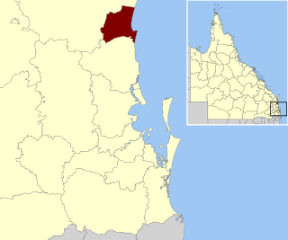
Peregian Beach is a beach and small coastal town on the Sunshine Coast, Queensland, Australia. It is a suburb split between two local government areas with the eastern coastal in the Shire of Noosa and the western hinterland part in the Sunshine Coast Region. In the 2021 census, the suburb of Peregian Beach had a population of 4,972 people.

<span class="mw-page-title-main">Shire of Noosa</span> Local government area in Queensland, Australia

The Shire of Noosa is a local government area about 130 kilometres (81 mi) north of Brisbane in the Sunshine Coast district of South East Queensland, Australia. The shire covers an area of 870 square kilometres (335.9 sq mi). It existed as a local government entity from 1910 until 2008, when it was amalgamated with the Shire of Maroochy and City of Caloundra to form the Sunshine Coast Region. The shire was re-established on 1 January 2014. In the 2021 census, the shire had a population of 56,298 people.

<span class="mw-page-title-main">Pomona, Queensland</span> Suburb of Sunshine Coast, Queensland, Australia

Pomona is a rural town and locality in the Shire of Noosa, Queensland, Australia. In the 2021 census the locality of Pomona had a population of 2,926 people in 2021 and is located around 135 kilometres north of Brisbane. The town was originally called Pinbarren Siding from 1890-1900 as a subsidiary to Pinbarren.

<span class="mw-page-title-main">Boreen Point, Queensland</span> Suburb of Noosa, Queensland, Australia

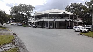
Boreen Point is a rural locality in the Shire of Noosa, Queensland, Australia. In the 2016 census, Boreen Point had a population of 328 people. The town of Boreen is located within the locality beside the lake, but the town name is rarely used with Boreen Point being the name in common usage.

<span class="mw-page-title-main">Lake Cootharaba</span> Lake in Queensland, Australia

Lake Cootharaba is a lake on the Noosa River within the locality of Noosa North Shore in the Shire of Noosa, Queensland, Australia. It is the gateway to the Everglades, a popular tourist attraction for Noosa, being 20 km away from Noosa. The lake's major access is the town of Boreen Point, as well as the smaller camping-spot of Elanda Point.

<span class="mw-page-title-main">Cooran, Queensland</span> Town in Queensland, Australia

Cooran is a rural hinterland town and locality in the Shire of Noosa, Queensland, Australia. In the 2016 census the locality of Cooran had a population of 1,624 people.

<span class="mw-page-title-main">Kin Kin</span> Suburb of Shire of Noosa, Queensland, Australia

Kin Kin is a rural town and locality in the Shire of Noosa, Queensland, Australia. In the 2016 census, the locality of Kin Kin had a population of 764 people. In the 2021 census the population had risen to 844.

Doonan is a rural residential locality split between the Sunshine Coast Region and the Shire of Noosa, both in Queensland, Australia. In the 2016 census, Doonan had a population of 3,459 people.

<span class="mw-page-title-main">Lake Macdonald, Queensland</span> Suburb of Sunshine Coast, Queensland, Australia

Lake Macdonald is a rural locality in the Shire of Noosa, Queensland, Australia. In the 2016 census Lake Macdonald had a population of 1,363 people.

<span class="mw-page-title-main">Tinbeerwah, Queensland</span> Suburb of Shire of Noosa, Queensland, Australia

Tinbeerwah is a semi-rural locality in the Shire of Noosa, Queensland, Australia. In the 2021 census, Tinbeerwah had a population of 1,160 people.

Federal is a rural locality in the Shire of Noosa, Queensland, Australia. It is located in the Sunshine Coast hinterland near the towns of Cooran and Pomona. In the 2021 census, Federal had a population of 365 people.

Ridgewood is a rural locality in the Shire of Noosa, Queensland, Australia. In the 2021 census, Ridgewood had a population of 317 people.

Black Mountain is a rural locality in the Shire of Noosa, Queensland, Australia. In the 2016 census, Black Mountain had a population of 1,444 people.

Ringtail Creek is a rural locality in the Shire of Noosa, Queensland, Australia. In the 2016 census Ringtail Creek had a population of 197 people.

Cooroy Mountain is a rural locality in the Shire of Noosa, Queensland, Australia. In the 2021 census, Cooroy Mountain had a population of 148 people.

<span class="mw-page-title-main">Como, Queensland</span> Suburb of Sunshine Coast, Queensland, Australia

Como is a rural locality in the Shire of Noosa, Queensland, Australia. In the 2021 census, Como had a population of 54 people.

<span class="mw-page-title-main">Eerwah Vale, Queensland</span> Suburb of Sunshine Coast, Queensland, Australia

Eerwah Vale is a locality split between the Sunshine Coast Region and Shire of Noosa, both in Queensland, Australia. In the 2016 census Eerwah Vale had a population of 621 people.

<span class="mw-page-title-main">Pomona State School</span> Primary school in Australia

Pomona State School is a government primary school in Pomona, Shire of Noosa, Queensland, Australia. It was established on 31 August 1897.

Perwillowen is a rural locality in the Sunshine Coast Region, Queensland, Australia. In the 2021 census, Perwillowen had a population of 213 people.

Coles Creek is a rural locality in the Gympie Region, Queensland, Australia. In the 2021 census, Coles Creek had a population of 68 people.

References

  1. Australian Bureau of Statistics (28 June 2022). "Cootharaba (suburb and locality)". Australian Census 2021 QuickStats. Retrieved 28 June 2022.  OOjs UI icon edit-ltr-progressive.svg
  2. "Cootharaba – locality in Shire of Noosa (entry 48586)". Queensland Place Names. Queensland Government . Retrieved 5 November 2019.
  3. "2021 Cootharaba, Census All persons QuickStats | Australian Bureau of Statistics". www.abs.gov.au. Retrieved 2 August 2023.
  4. South East Queensland – Place Names Archived 22 June 2005 at the Wayback Machine 16 December 2006
  5. 1 2 3 Queensland Family History Society (2010), Queensland schools past and present (Version 1.01 ed.), Queensland Family History Society, ISBN   978-1-921171-26-0
  6. Queensland Family History Society (2010), Queensland schools past and present (Version 1.01 ed.), Queensland Family History Society, ISBN   978-1-921171-26-0
  7. "Queensland Two Mile series sheet 2m76" (Map). Queensland Government. 1943. Retrieved 27 October 2022.
  8. Christie, Heather, ed. (1997). Celebrating the past, Sharing the Future – Pomona State School Centenary 1987-1997 (PDF). Vol. 1. Pomona, QLD: Pomona State School.
  9. "Cooroy" (Map). Queensland Government. 1942. Archived from the original on 28 December 2020. Retrieved 25 October 2021.
  10. "Queensland Two Mile series sheet 2m76" (Map). Queensland Government. 1943. Archived from the original on 5 May 2021. Retrieved 25 October 2021.
  11. "Queensland Globe". State of Queensland . Retrieved 24 October 2021.
  12. "Backward Glance: History of Local Government on the Sunshine Coast". Sunshine Coast Regional Council . Retrieved 2 August 2023.
  13. "The Noosa De-amalgamation: Building a New Organisation". Noosa Shire Council . 2 January 2014. pp. 8–9. Retrieved 2 August 2023.
  14. Australian Bureau of Statistics (31 October 2012). "Cootharaba (State Suburb)". 2011 Census QuickStats. Retrieved 15 October 2014. OOjs UI icon edit-ltr-progressive.svg
  15. Australian Bureau of Statistics (27 June 2017). "Cootharaba (SSC)". 2016 Census QuickStats. Retrieved 20 October 2018. OOjs UI icon edit-ltr-progressive.svg
  16. "2021 Cootharaba, Census All persons QuickStats | Australian Bureau of Statistics". www.abs.gov.au. Retrieved 2 August 2023.
  17. "Crime & Disadvantage Cootharaba Qld 4565". www.microburbs.com.au. Retrieved 2 August 2023.

Further reading