
Cooroy is a rural town and locality in the Shire of Noosa, Queensland, Australia. In the 2021 census, the locality of Cooroy had a population of 4,801 people.

Tewantin is a town and locality in the Shire of Noosa, Queensland, Australia. Tewantin was the original settlement in the Noosa region and is one of its three major centres today. In the 2021 census, the locality of Tewantin had a population of 11,164 people.
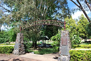
Kenilworth is a rural town and locality in the Sunshine Coast Region, Queensland, Australia. In the 2021 census, the locality of Kenilworth had a population of 604 people.
The M1 in Queensland, Australia, is a major urban road corridor. It connects the Sunshine Coast hinterland to Tugun, near the New South Wales and Queensland border, via the following corridors:
Doonan is a rural residential locality split between the Sunshine Coast Region and the Shire of Noosa, both in Queensland, Australia. In the 2021 census, Doonan had a population of 3,727 people.
Tinbeerwah is a semi-rural locality in the Shire of Noosa, Queensland, Australia. In the 2021 census, Tinbeerwah had a population of 1,160 people.
Ridgewood is a rural locality in the Shire of Noosa, Queensland, Australia. In the 2021 census, Ridgewood had a population of 317 people.
Black Mountain is a rural locality in the Shire of Noosa, Queensland, Australia. In the 2021 census, Black Mountain had a population of 1,560 people.

Pinbarren is a rural town and locality in the Shire of Noosa, Queensland, Australia. In the 2021 census, the locality of Pinbarren had a population of 447 people.
Cooroy Mountain is a rural locality in the Shire of Noosa, Queensland, Australia. In the 2021 census, Cooroy Mountain had a population of 148 people.
Verrierdale is a rural locality in the Sunshine Coast Region, Queensland, Australia. In the 2021 census, Verrierdale had a population of 809 people.
Carters Ridge is a rural locality in the Gympie Region, Queensland, Australia. In the 2021 census, Carters Ridge had a population of 497 people.

Eerwah Vale is a locality split between the Sunshine Coast Region and Shire of Noosa, both in Queensland, Australia. In the 2021 census, Eerwah Vale had a population of 671 people.
Valdora is a rural locality in the Sunshine Coast Region, Queensland, Australia. In the 2021 census, Valdora had a population of 776 people.
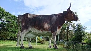
Kulangoor is a locality in the Sunshine Coast Region, Queensland, Australia. It was known as the home of The Big Cow for many years. In the 2021 census, Kulangoor had a population of 455 people.
Bridges is a rural locality in the Sunshine Coast Region, Queensland, Australia. In the 2021 census, Bridges had a population of 295 people.

Kiamba is a rural locality in the Sunshine Coast Region, Queensland, Australia. In the 2021 census, Kiamba had a population of 191 people.
Coles Creek is a rural locality in the Gympie Region, Queensland, Australia. In the 2021 census, Coles Creek had a population of 68 people.
Eumundi–Noosa Road is a continuous 15.8-kilometre (9.8 mi) road route in the Sunshine Coast and Noosa local government areas of Queensland, Australia. It is signed as State Route 12 for most of its length. For a short distance in Noosaville it is part of State Route 6. It is a state-controlled regional road for most of its length. Part of it is rated as a local road of regional significance (LRRS).


