Coes Creek, Queensland

Last updated

Map all coordinates using: OpenStreetMap
Coes Creek
Sunshine Coast,  Queensland
Australia Queensland location map.svg
Red pog.svg
Coes Creek
Coordinates 26°38′54″S152°56′34″E / 26.6483°S 152.9427°E / -26.6483; 152.9427 (Coes Creek (centre of locality))
Population1,515 (SAL 2021) [1]
Postcode(s) 4560
Area2.5 km2 (1.0 sq mi)
Time zone AEST (UTC+10:00)
Location
LGA(s) Sunshine Coast Region
State electorate(s) Nicklin
Federal division(s) Fairfax
Suburbs around Coes Creek:
Perwillowen Burnside Nambour
Towen Mountain Coes Creek Woombye
West Woombye West Woombye Woombye

Coes Creek is a rural locality in the Sunshine Coast Region, Queensland, Australia. [2] In the 2021 census, Coes Creek had a population of 1,515 people. [3]

Contents

Geography

The eastern boundary of Coes Creek is marked by Petrie Creek, a tributary of the Maroochy River. [4]

History

The locality takes its name from the creek, which in turn was named after selector Robert Coe, who was killed by a train. [5] [6] The Queensland Place Names Board approved the naming of the creek and the district after Coe on 1 December 1962. [2]

Demographics

In the 2016 census, Coes Creek had a population of 1,392 people. [7]

In the 2021 census, Coes Creek had a population of 1,515 people. [3] The population of Coes Creek comprises 47.9% males, 52.1% females, with a median age of 43. [8]

Education

There are no schools in Coes Creek. The nearest government primary and secondary schools are Burnside State School and Burnside State High School, both in neighbouring Burnside to the north. [4]

In Coes Creek, 41.4% of adult residents have successfully completed high school. [9]

Amenities

There are a number of parks in the area:

Facilities

The Maroochy Research Facility is on a 64-hectare (160-acre) site at 47 Mayers Road ( 26°38′36″S152°56′16″E / 26.6434°S 152.9379°E / -26.6434; 152.9379 (Maroochy research facility) ). It is operated by the Department of Agriculture and Fisheries and focuses on research on growing sub-tropical crops, including strawberries, stone fruit, custard apples, pineapples and ginger. [11]

Related Research Articles

<span class="mw-page-title-main">Nambour</span> Suburb of Sunshine Coast, Queensland, Australia

Nambour is a rural town and locality in the Sunshine Coast Region, Queensland, Australia. In the 2016 census, the locality of Nambour had a population of 11,187 people.

Montville is a rural town and locality in the Sunshine Coast Region, Queensland, Australia. In the 2016 census, the locality of Montville had a population of 970 people.

<span class="mw-page-title-main">Woombye, Queensland</span> Town in Queensland, Australia

Woombye is a rural town and locality in the Sunshine Coast Region, Queensland, Australia. In the 2021 census, the locality of Woombye had a population of 3,944 people.

Diddillibah is a semi-rural locality in the Sunshine Coast Region, Queensland, Australia. In the 2016 census, Diddillibah had a population of 1,403 people. In the 2021 census, Diddillibah had a population of 1,703 people.

<span class="mw-page-title-main">Eerwah Vale, Queensland</span> Suburb of Sunshine Coast, Queensland, Australia

Eerwah Vale is a locality split between the Sunshine Coast Region and Shire of Noosa, both in Queensland, Australia. In the 2016 census Eerwah Vale had a population of 621 people.

<span class="mw-page-title-main">Maroochy River, Queensland</span> Suburb of Sunshine Coast Region, Queensland, Australia

Maroochy River is a rural hinterland locality in the Sunshine Coast Region, Queensland, Australia. In the 2016 census Maroochy River had a population of 1,531 people.

<span class="mw-page-title-main">Ninderry, Queensland</span> Town in Queensland, Australia

Ninderry is a rural town and locality in the Sunshine Coast Region, Queensland, Australia. In the 2016 census, the locality of Ninderry had a population of 1,087 people.

<span class="mw-page-title-main">Burnside, Queensland</span> Suburb of Nambour, Queensland, Australia

Burnside is a residential locality of the town of Nambour in the Sunshine Coast Region, Queensland, Australia. In the 2021 census, Burnside had a population of 3,104 people.

West Woombye is a rural residential locality in the Sunshine Coast Region, Queensland, Australia. In the 2016 census West Woombye had a population of 1,007 people.

Chevallum is a rural locality in the Sunshine Coast Region, Queensland, Australia. In the 2016 census, Chevallum had a population of 441 people. In the 2021 census, Chevallum had a population of 467 people.

Kiels Mountain is a rural locality in the Sunshine Coast Region, Queensland, Australia. In the 2016 census, Kiels Mountain had a population of 664 people.

Hunchy is a rural locality in the Sunshine Coast, Queensland, Australia. In the 2021 census, Hunchy had a population of 592 people.

<span class="mw-page-title-main">Obi Obi, Queensland</span> Suburb of Sunshine Coast Region, Queensland, Australia

Obi Obi is a rural locality in the Sunshine Coast Region, Queensland, Australia. In the 2021 census, Obi Obi had a population of 208 people.

<span class="mw-page-title-main">Flaxton, Queensland</span> Suburb of Sunshine Coast Region, Queensland, Australia

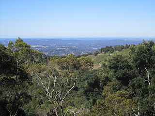
Flaxton is a rural locality in the Sunshine Coast Region, Queensland, Australia. In the 2021 census, Flaxton had a population of 992 people.

<span class="mw-page-title-main">Colinton, Queensland</span> Suburb of Somerset Region, Queensland, Australia

Colinton is a rural locality in the Somerset Region, Queensland, Australia. In the 2016 census, Colinton had a population of 75 people.

<span class="mw-page-title-main">Dulong, Queensland</span> Suburb of Sunshine Coast Region, Queensland, Australia

Dulong is a rural locality in the Sunshine Coast Region, Queensland, Australia. In the 2021 census, Dulong had a population of 688 people.

Kidaman Creek is a rural locality in the Sunshine Coast Region, Queensland, Australia. In the 2016 census Kidaman Creek had a population of 130 people.

Kureelpa is a rural locality in the Sunshine Coast Region, Queensland, Australia. In the 2021 census, Kureelpa had a population of 968 people.

Perwillowen is a rural locality in the Sunshine Coast Region, Queensland, Australia. In the 2021 census, Perwillowen had a population of 213 people.

Bridges is a rural locality in the Sunshine Coast Region, Queensland, Australia. In the 2016 census Bridges had a population of 276 people.

References

  1. Australian Bureau of Statistics (28 June 2022). "Coes Creek (suburb and locality)". Australian Census 2021 QuickStats. Retrieved 28 June 2022.  OOjs UI icon edit-ltr-progressive.svg
  2. 1 2 "Coes Creek – locality in Sunshine Coast Region (entry 48573)". Queensland Place Names. Queensland Government . Retrieved 5 November 2019.
  3. 1 2 Australian Bureau of Statistics (28 June 2022). "Coes Creek (SAL)". 2021 Census QuickStats. Retrieved 28 February 2023. OOjs UI icon edit-ltr-progressive.svg
  4. 1 2 "Queensland Globe". State of Queensland . Retrieved 7 August 2023.
  5. "FATAL ACCIDENT AT WOOMBYE". The Brisbane Courier . Vol. LII, no. 11, 882. Queensland, Australia. 13 February 1896. p. 5. Archived from the original on 7 August 2023. Retrieved 14 November 2019 via National Library of Australia.
  6. "NOTES and NEWS". Gympie Times And Mary River Mining Gazette . Vol. XXVIII, no. 3401. Queensland, Australia. 13 February 1896. p. 3. Archived from the original on 7 August 2023. Retrieved 14 November 2019 via National Library of Australia.
  7. Australian Bureau of Statistics (27 June 2017). "Coes Creek (SSC)". 2016 Census QuickStats. Retrieved 20 October 2018. OOjs UI icon edit-ltr-progressive.svg
  8. "2021 Coes Creek, Census All persons QuickStats | Australian Bureau of Statistics". abs.gov.au. Retrieved 18 August 2023.
  9. "Affluence & Economy Coes Creek Qld 4560". microburbs.com.au. Retrieved 18 August 2023.
  10. 1 2 3 4 "Land for public recreation – Queensland". Queensland Open Data. Queensland Government. 20 November 2020. Archived from the original on 22 November 2020. Retrieved 22 November 2020.
  11. "Maroochy research facility". Department of Agriculture and Fisheries. Queensland Government. Archived from the original on 1 August 2023. Retrieved 7 August 2023.