
Maleny is a rural town and locality in the Sunshine Coast Region, Queensland, Australia. Maleny was a timber town until the early 1920s and then was a centre of dairy production and fruit growing. In the 2021 census, the locality of Maleny had a population of 3,959 people.
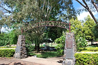
Kenilworth is a rural town and locality in the Sunshine Coast Region, Queensland, Australia. In the 2021 census, the locality of Kenilworth had a population of 604 people.

Mooloolah Valley is a rural locality in the Sunshine Coast Region, Queensland, Australia. In the 2021 census, Mooloolah Valley had a population of 3,629 people.
Montville is a rural town and locality in the Sunshine Coast Region, Queensland, Australia. In the 2021 census, the locality of Montville had a population of 1,092 people.
Eudlo is a rural town and locality in the Sunshine Coast Region, Queensland, Australia. In the 2021 census, the locality of Eudlo had a population of 1,192 people.
Minden is a rural town and locality in the Somerset Region, Queensland, Australia. The town is 64 kilometres (40 mi) west of the state capital, Brisbane. In the 2021 census, the locality of Minden had a population of 1,227 people.
Bellthorpe is a rural locality in the City of Moreton Bay, Queensland, Australia. In the 2021 census, Bellthorpe had a population of 108 people.
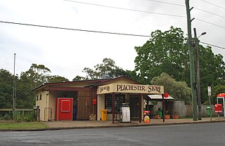
Peachester is a rural town and locality in the Sunshine Coast Region, Queensland, Australia. In the 2021 census, the locality of Peachester had a population of 1,460 people.

Cedar Creek is a locality split between City of Gold Coast and Logan City in Queensland, Australia. In the 2021 census, Cedar Creek had a population of 861 people.
Hunchy is a rural locality in the Sunshine Coast, Queensland, Australia. In the 2021 census, Hunchy had a population of 592 people.

Obi Obi is a rural locality in the Sunshine Coast Region, Queensland, Australia. In the 2021 census, Obi Obi had a population of 208 people.

Tinana is a rural town and locality in the Fraser Coast Region, Queensland, Australia. In the 2021 census, the locality of Tinana had a population of 5,872 people.

Booroobin is a rural locality split between the City of Moreton Bay and the Sunshine Coast Region in Queensland, Australia. In the 2021 census, Booroobin had a population of 258 people.
Bald Knob is a rural locality in the Sunshine Coast Region, Queensland, Australia. In the 2021 census, Bald Knob had a population of 280 people.

Balmoral Ridge is a rural locality in the Sunshine Coast Region, Queensland, Australia. In the 2021 census, Balmoral Ridge had a population of 302 people.

Cambroon is a rural locality in the Sunshine Coast Region, Queensland, Australia. In the 2021 census, Cambroon had a population of 211 people.

Wootha is a rural locality in the Sunshine Coast Region, Queensland, Australia. In the 2021 census, Wootha had a population of 258 people.
Curramore is a rural locality in the Sunshine Coast Region, Queensland, Australia. In the 2021 census, Curramore had a population of 198 people.

Diamond Valley is a rural locality in the Sunshine Coast Region, Queensland, Australia. In the 2021 census, Diamond Valley had a population of 489 people.
North Branch is a locality in the Toowoomba Region, Queensland, Australia. In the 2021 census, North Branch had a population of 48 people.


