Image Flat, Queensland

Last updated

Image Flat
Sunshine Coast,  Queensland
Australia Queensland location map.svg
Red pog.svg
Image Flat
Coordinates 26°35′55″S152°56′04″E / 26.5986°S 152.9344°E / -26.5986; 152.9344 (Image Flat (centre of locality))
Population457 (2021 census) [1]
 • Density48.62/km2 (125.9/sq mi)
Postcode(s) 4560
Area9.4 km2 (3.6 sq mi)
Time zone AEST (UTC+10:00)
Location
LGA(s) Sunshine Coast Region
State electorate(s) Fairfax
Federal division(s) Nicklin
Suburbs around Image Flat:
Kiamba Kulangoor Kulangoor
Kureelpa Image Flat Parklands
Kureelpa Highworth Nambour

Image Flat is a rural locality in the Sunshine Coast Region, Queensland, Australia. [2] In the 2021 census, Image Flat had a population of 457 people. [1]

Contents

Geography

The locality is on the outskirts of Nambour. The land use is a mix of rural residential housing and grazing on native vegetation. [3]

History

A rural farming area, the locale was named prior to 1896. A government receiving office was opened in 1901. [4] During the 1910s, the area had market gardens. [5] Sugar cane was then complemented by a dairy industry, and later as free from frost, bananas. [6] There was a notable Finnish population at one time. [7] [8]

In the late 1890s, a sugar cane tramway was constructed that terminated at Image Flat. [9] [10] By 1903, the line had been extended, but having to address a 1:23 grade. [11] [12] The cane trolleys were being drawn by horses until picked up further along by a locomotive, for the Moreton Central Sugar Cane Company Limited. [13] A line extension was still being sought by 1923. [14] Sugar cane pests and diseases had an impact in the local industry in 1924. [15] In 1954, the concern had crossed to the Panama disease in bananas. [16]

A committee was formed by 1951 seeking to bring electrical light and power to the area, although this had been proposed by a Nambour committee in 1923. [17] [18]

Demographics

In the 2011 census, Image Flat had a population of 462 people. [19]

In the 2016 census, Image Flat had a population of 443 people. [20]

In the 2021 census, Image Flat had a population of 457 people. [1]

Education

There are no schools in Image Flat. Nambour State College in neighbouring Nambour to the south-east is the nearest government primary and secondary school. [3]

Related Research Articles

<span class="mw-page-title-main">Maryborough, Queensland</span> City in Queensland, Australia

Maryborough is a city and a suburb in the Fraser Coast Region, Queensland, Australia. At the 2021 Census, the suburb of Maryborough had a population of 15,287.

<span class="mw-page-title-main">Sunshine Coast, Queensland</span> Region in Queensland, Australia

The Sunshine Coast is a peri-urban region in South East Queensland, Australia. It is the district defined in 1967 as "the area contained in the Shires of Landsborough, Maroochy and Noosa, but excluding Bribie Island". Located 100 km (62 mi) north of the centre of Brisbane in South East Queensland, on the Coral Sea coastline, its urban area spans approximately 60 km (37 mi) of coastline and hinterland from Pelican Waters to Tewantin.

<span class="mw-page-title-main">Nambour</span> Suburb of Sunshine Coast, Queensland, Australia

Nambour is a rural town and locality in the Sunshine Coast Region, Queensland, Australia. In the 2016 census, the locality of Nambour had a population of 11,187 people.

<span class="mw-page-title-main">Palmwoods, Queensland</span> Town in Queensland, Australia

Palmwoods is a rural town and locality in the Sunshine Coast Region, Queensland, Australia. In the 2021 census, the locality of Palmwoods had a population of 6,357 people.

<span class="mw-page-title-main">Yandina, Queensland</span> Town in Queensland, Australia

Yandina is a rural town and locality in the Sunshine Coast Region, Queensland, Australia. IIn the 2021 census, the locality of Yandina had a population of 3,073 people.

<span class="mw-page-title-main">Mooloolah Valley, Queensland</span> Suburb of Sunshine Coast Region, Queensland, Australia

Mooloolah Valley is a rural locality in the Sunshine Coast Region, Queensland, Australia. In the 2021 census, Mooloolah Valley had a population of 3,629 people.

<span class="mw-page-title-main">Woombye, Queensland</span> Town in Queensland, Australia

Woombye is a rural town and locality in the Sunshine Coast Region, Queensland, Australia. In the 2021 census, the locality of Woombye had a population of 3,944 people.

Eudlo is a rural town and locality in the Sunshine Coast Region, Queensland, Australia. In the 2016 census, the locality of Eudlo had a population of 1,117 people.

<span class="mw-page-title-main">Eerwah Vale, Queensland</span> Suburb of Sunshine Coast, Queensland, Australia

Eerwah Vale is a locality split between the Sunshine Coast Region and Shire of Noosa, both in Queensland, Australia. In the 2021 census, Eerwah Vale had a population of 671 people.

<span class="mw-page-title-main">Bulwer, Queensland</span> Town in Queensland, Australia

Bulwer is a coastal town and locality at the north-western end of Moreton Island in the City of Brisbane, Queensland, Australia. In the 2021 census, Bulwer had a population of 59 people.

<span class="mw-page-title-main">Queensland Country Women's Association</span> Womens organisation in Queensland, Australia

The Queensland Country Women's Association (QCWA) is the Queensland chapter of the Country Women's Association in Australia. The association seeks to serve the interests of women and children in rural areas in Australia through a network of local branches. Established in 1922, local branches provide friendship and mutual support to their members while contributing to the betterment of life in their local communities. Over time, many branches have evolved to include support for wider issues such as domestic violence campaigns and fund-raising for international initiatives such as orphanages.

<span class="mw-page-title-main">Moreton Central Sugar Mill Cane Tramway</span> Historic site in Queensland, Australia

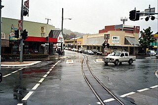
Moreton Central Sugar Mill Cane Tramway is a heritage-listed tramway at Mill Street, Currie Street, and Howard Street, in Nambour, Sunshine Coast Region, Queensland, Australia. It was built c. 1897. It was added to the Queensland Heritage Register on 7 February 2005.

<span class="mw-page-title-main">Bauple, Queensland</span> Town in Queensland, Australia

Bauple is a rural town and locality in the Fraser Coast Region, Queensland, Australia. In the 2016 census the locality of Bauple had a population of 644 people.

Moreton Central Sugar Mill was a sugar milling facility in Nambour, Queensland, Australia owned by Bundaberg Sugar Ltd.

Kureelpa is a rural locality in the Sunshine Coast Region, Queensland, Australia. In the 2021 census, Kureelpa had a population of 968 people.

Perwillowen is a rural locality in the Sunshine Coast Region, Queensland, Australia. In the 2021 census, Perwillowen had a population of 213 people.

<span class="mw-page-title-main">Kiamba, Queensland</span> Suburb of Sunshine Coast Region, Queensland, Australia

Kiamba is a rural locality in the Sunshine Coast Region, Queensland, Australia. In the 2021 census, Kiamba had a population of 191 people.

<span class="mw-page-title-main">Biarra, Queensland</span> Suburb of Somerset Region, Queensland, Australia

Biarra is a rural locality in the Somerset Region, Queensland, Australia. In the 2021 census, Biarra had a population of 270 people.

<span class="mw-page-title-main">Marodian, Queensland</span> Suburb of Fraser Coast Region, Queensland, Australia

Marodian is a rural locality in the Fraser Coast Region, Queensland, Australia. In the 2021 census, Marodian had a population of 4 people.

References

  1. 1 2 3 Australian Bureau of Statistics (28 June 2022). "Image Flat (SAL)". 2021 Census QuickStats. Retrieved 28 February 2023. OOjs UI icon edit-ltr-progressive.svg
  2. "Image Flat – locality in Sunshine Coast Region (entry 48677)". Queensland Place Names. Queensland Government . Retrieved 28 October 2019.
  3. 1 2 "Queensland Globe". State of Queensland . Retrieved 9 August 2023.
  4. "OFFICIAL ITEMS". The Brisbane Courier . Vol. LVII, no. 13, 490. Queensland, Australia. 8 April 1901. p. 8. Archived from the original on 9 August 2023. Retrieved 28 October 2019 via National Library of Australia.
  5. "Hail at Image Flat". Chronicle And North Coast Advertiser . Vol. XIII, no. 626. Queensland, Australia. 22 October 1915. p. 5. Archived from the original on 9 August 2023. Retrieved 26 October 2019 via National Library of Australia.
  6. "Advertising". Daily Mail . No. 4426. Queensland, Australia. 5 May 1917. p. 12. Archived from the original on 9 August 2023. Retrieved 26 October 2019 via National Library of Australia.
  7. "Fun amongst the Finns". Chronicle And North Coast Advertiser . Vol. 2, no. [?]. Queensland, Australia. 5 August 1904. p. 2. Archived from the original on 9 August 2023. Retrieved 26 October 2019 via National Library of Australia.
  8. "The truth about the Finns". Chronicle And North Coast Advertiser . Vol. 5, no. 233. Queensland, Australia. 18 January 1908. p. 3. Archived from the original on 9 August 2023. Retrieved 26 October 2019 via National Library of Australia.
  9. "Classified Advertising". The Brisbane Courier . Vol. LIV, no. 12, 598. Queensland, Australia. 28 May 1898. p. 8. Archived from the original on 9 August 2023. Retrieved 26 October 2019 via National Library of Australia.
  10. "Moreton Central Mill Meeting". Moreton Mail. Vol. XIV, no. 711. Queensland, Australia. 3 March 1899. p. 5. Archived from the original on 9 August 2023. Retrieved 26 October 2019 via National Library of Australia.
  11. "The Dulong Tramway". The Brisbane Courier . Vol. LIX, no. 13, 960. Queensland, Australia. 9 October 1902. p. 2. Archived from the original on 9 August 2023. Retrieved 26 October 2019 via National Library of Australia.
  12. "Moreton Sugar Mill". The Telegraph . No. 9, 435. Queensland, Australia. 16 February 1903. p. 4 (Second edition). Archived from the original on 9 August 2023. Retrieved 26 October 2019 via National Library of Australia.
  13. "Mill Directors' Inspection". Chronicle And North Coast Advertiser . Vol. 6, no. 294. Queensland, Australia. 13 February 1909. p. 3. Archived from the original on 9 August 2023. Retrieved 26 October 2019 via National Library of Australia.
  14. "Maroochy Shire Council". Nambour Chronicle And North Coast Advertiser . Vol. XX, no. 1028. Queensland, Australia. 20 July 1923. p. 5. Archived from the original on 9 August 2023. Retrieved 26 October 2019 via National Library of Australia.
  15. "Cane diseases". The Queenslander . No. 5920. Queensland, Australia. 27 September 1924. p. 39. Archived from the original on 9 August 2023. Retrieved 27 October 2019 via National Library of Australia.
  16. "Banana Inspections". Nambour Chronicle And North Coast Advertiser . Queensland, Australia. 16 July 1954. p. 4. Archived from the original on 9 August 2023. Retrieved 27 October 2019 via National Library of Australia.
  17. "Nambour progress". The Brisbane Courier . No. 20, 346. Queensland, Australia. 9 April 1923. p. 8. Archived from the original on 9 August 2023. Retrieved 26 October 2019 via National Library of Australia.
  18. "Electric Light Development". Nambour Chronicle And North Coast Advertiser . No. 2439. Queensland, Australia. 16 March 1951. p. 3. Archived from the original on 9 August 2023. Retrieved 26 October 2019 via National Library of Australia.
  19. Australian Bureau of Statistics (31 October 2012). "Image Flat". 2011 Census QuickStats. Retrieved 31 December 2012. OOjs UI icon edit-ltr-progressive.svg
  20. Australian Bureau of Statistics (27 June 2017). "Image Flat (SSC)". 2016 Census QuickStats. Retrieved 20 October 2018. OOjs UI icon edit-ltr-progressive.svg