Yandina Creek, Queensland

Last updated

Yandina Creek
Queensland
Australia Queensland location map.svg
Red pog.svg
Yandina Creek
Coordinates 26°31′35″S153°01′35″E / 26.5263°S 153.0263°E / -26.5263; 153.0263 (Yandina Creek (centre of locality))
Population760 (2016 census) [1]
 • Density28.90/km2 (74.8/sq mi)
Postcode(s) 4561
Area26.3 km2 (10.2 sq mi)
Time zone AEST (UTC+10:00)
Location
LGA(s) Sunshine Coast Region
State electorate(s) Ninderry
Federal division(s) Fairfax
Suburbs around Yandina Creek:
North Arm Verrierdale Verrierdale
Valdora Yandina Creek Coolum Beach
Maroochy River Maroochy River Coolum Beach

Yandina Creek is a rural locality in the Sunshine Coast Region, Queensland, Australia. [2] In the 2016 census, Yandina Creek had a population of 760 people. [1]

Contents

Geography

Yandina Creek is in the Sunshine Coast hinterland. [3] The Yandina-Coolum Road runs along the western boundary before crossing to the east. [4]

History

The name Yandina comes from Indigenous words yan meaning to go and dinna meaning feet. [5] [6]

Yandina Creek Provisional School opened on 16 June 1914. On 1 May 1917, it became Yandina Creek State School. It closed on 30 September 1920. On 9 May 1932, the school reopened and then closed in December 1941. [7] In 1949, the school building from the former Valdora State School was relocated to Yandina Creek and re-opened on 1 February 1949 as Yandina Creek State School. It closed on 7 August 1964. [7] The school was at 931 North Arm Yandina Creek Road ( 26°30′41″S153°01′01″E / 26.5115°S 153.0169°E / -26.5115; 153.0169 (Yandina Creek State School (former)) ). [8] [3]

On 4 January 2004, Coolum Beach Christian College was established by the Coolum Christian Family Church with 35 primary school children. [7] In 2007, it expanded to offer secondary education. [9]

In the 2016 census, Yandina Creek had a population of 760 people. [1]

Education

Coolum Beach Christian College is a private primary and secondary (Prep-12) school for boys and girls at 2 Arcoona Road ( 26°32′07″S153°02′50″E / 26.5354°S 153.0472°E / -26.5354; 153.0472 (Coolum Beach Christian College) ). [10] [11] In 2017, the school had an enrolment of 295 students with 23 teachers (20 full-time equivalent) and 23 non-teaching staff (13 full-time equivalent). [12] In 2018, the school had an enrolment of 356 students with 28 teachers (25 full-time equivalent) and 24 non-teaching staff (15 full-time equivalent). [13]

The nearest government primary schools are in Coolum Beach and North Arm. The nearest government secondary schools are in Coolum Beach and Nambour. [3]

Related Research Articles

<span class="mw-page-title-main">Yandina, Queensland</span> Town in Queensland, Australia

Yandina is a rural town and locality in the Sunshine Coast Region, Queensland, Australia. IIn the 2021 census, the locality of Yandina had a population of 3,073 people.

<span class="mw-page-title-main">Bli Bli, Queensland</span> Suburb of Sunshine Coast Region, Division 9, Queensland, Australia

Bli Bli is a rural town and locality in the Sunshine Coast Region, Queensland, Australia. In the 2021 census, Bli Bli had a population of 10,750 people.

<span class="mw-page-title-main">Coolum Beach, Queensland</span> Suburb of Sunshine Coast, Queensland, Australia

Coolum Beach is a beachside town and coastal suburb in the Sunshine Coast Region, Queensland, Australia. In the 2016 census, the suburb of Coolum Beach had a population of 8,497 people. In the 2021 census, Coolum Beach had a population of 15,948 people.

<span class="mw-page-title-main">Forest Glen, Queensland</span> Suburb of Sunshine Coast, Queensland, Australia

Forest Glen is a rural residential locality in the Sunshine Coast Region, Queensland, Australia. In the 2016 census, Forest Glen had a population of 1,390 people.

Doonan is a rural residential locality split between the Sunshine Coast Region and the Shire of Noosa, both in Queensland, Australia. In the 2016 census, Doonan had a population of 3,459 people.

Kuluin is a suburb of Maroochydore in the Sunshine Coast Region, Queensland, Australia. Kuluin had a population of 2,363 people in the 2016 census and 2,700 in the 2021 census.

<span class="mw-page-title-main">Point Arkwright, Queensland</span> Suburb of Sunshine Coast, Queensland, Australia

Point Arkwright is a coastal suburb in the Sunshine Coast Region, Queensland, Australia. In the 2016 census, Point Arkwright had a population of 273 people.

North Arm is a rural town and locality in the Sunshine Coast Region, Queensland, Australia. In the 2016 census, the locality of North Arm had a population of 657 people.

<span class="mw-page-title-main">Maroochy River, Queensland</span> Suburb of Sunshine Coast Region, Queensland, Australia

Maroochy River is a rural hinterland locality in the Sunshine Coast Region, Queensland, Australia. In the 2016 census Maroochy River had a population of 1,531 people.

<span class="mw-page-title-main">Ninderry, Queensland</span> Town in Queensland, Australia

Ninderry is a rural town and locality in the Sunshine Coast Region, Queensland, Australia. In the 2016 census, the locality of Ninderry had a population of 1,087 people.

Valdora is a rural locality in the Sunshine Coast Region, Queensland, Australia. In the 2021 census, Valdora had a population of 776 people.

<span class="mw-page-title-main">Maroochy River</span> River in Queensland, Australia

The Maroochy River is a river in South East Queensland, Australia. The river rises from the eastern slopes of the Blackall Range and flows east through Eumundi, before entering the sea at Cotton Tree, Maroochydore. Other populated centres in the catchment include Nambour, Eudlo, Yandina and Coolum.

<span class="mw-page-title-main">Electoral district of Ninderry</span> State electoral district of Queensland, Australia

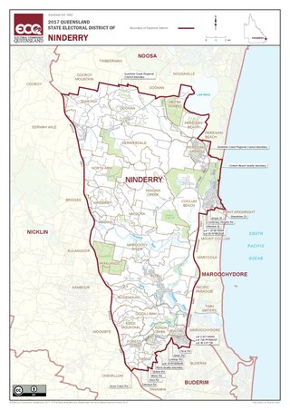
Ninderry is an electoral district of the Legislative Assembly in the Australian state of Queensland. It was created in the 2017 redistribution.

Cooloolabin is a rural locality in the Sunshine Coast Region, Queensland, Australia. In the 2016 census Cooloolabin had a population of 257 people.

<span class="mw-page-title-main">Kulangoor, Queensland</span> Suburb of Sunshine Coast Region, Queensland, Australia

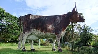
Kulangoor is a locality in the Sunshine Coast Region, Queensland, Australia. It was known as the home of The Big Cow for many years. In the 2021 census, Kulangoor had a population of 455 people.

Kureelpa is a rural locality in the Sunshine Coast Region, Queensland, Australia. In the 2021 census, Kureelpa had a population of 968 people.

Bridges is a rural locality in the Sunshine Coast Region, Queensland, Australia. In the 2016 census Bridges had a population of 276 people.

Kiamba is a small Queensland, rural locality within Australia. Region of Kiamba is sunshine coast, state of Queensland, Australia. Koppen climate type is Cfa : Humid subtropical climate. It is located approximately 100 km from the capital Brisbane covering an area of 16.481 square kilometres. Kiamba has a recorded population of 191 residents. There is Australian Eastern Standard Time zone Australia/Brisbane.

Yandina–Coolum Road is a continuous 18.5-kilometre (11.5 mi) road route in the Sunshine Coast local government area of Queensland, Australia. The route is signed as State Route 11. It is a state-controlled district road, rated as a local road of regional significance (LRRS).

References

  1. 1 2 3 Australian Bureau of Statistics (27 June 2017). "Yandina Creek (SSC)". 2016 Census QuickStats. Retrieved 20 October 2018. OOjs UI icon edit-ltr-progressive.svg
  2. "Yandina Creek – locality in Sunshine Coast Region (entry 49690)". Queensland Place Names. Queensland Government . Retrieved 7 March 2022.
  3. 1 2 3 "Queensland Globe". State of Queensland . Retrieved 17 October 2021.
  4. Google (18 November 2023). "Yandina Creek, Queensland" (Map). Google Maps . Google. Retrieved 18 November 2023.
  5. "South East Queensland – Place Names". Archived from the original on 21 August 2006. Retrieved 16 December 2006.
  6. "Maroochy Council – Place Name Origins". Archived from the original on 10 December 2006. Retrieved 16 December 2006.
  7. 1 2 3 Queensland Family History Society (2010), Queensland schools past and present (Version 1.01 ed.), Queensland Family History Society, ISBN   978-1-921171-26-0
  8. "Queensland Two Mile series sheet 2m76" (Map). Queensland Government. 1943. Archived from the original on 5 May 2021. Retrieved 17 October 2021.
  9. "Our Story". Coolum Beach Christian College. Retrieved 19 July 2022.
  10. "State and non-state school details". Queensland Government. 9 July 2018. Archived from the original on 21 November 2018. Retrieved 21 November 2018.
  11. "Coolum Beach Christian College". Archived from the original on 14 October 2018. Retrieved 21 November 2018.
  12. "ACARA School Profile 2017". Archived from the original on 22 November 2018. Retrieved 22 November 2018.
  13. "ACARA School Profile 2018". Australian Curriculum, Assessment and Reporting Authority. Archived from the original on 27 August 2020. Retrieved 28 January 2020.

Further reading