Wurtulla, Queensland

Last updated

Wurtulla
Kawana Waters,  Queensland
Fisherman at Dawn, Wurtulla Beach, 2012.jpg
Fisherman at Dawn, Wurtulla Beach, 2012
Australia Queensland location map.svg
Red pog.svg
Wurtulla
Coordinates 26°45′20″S153°07′36″E / 26.7555°S 153.1266°E / -26.7555; 153.1266 (Wurtulla (centre of suburb)) Coordinates: 26°45′20″S153°07′36″E / 26.7555°S 153.1266°E / -26.7555; 153.1266 (Wurtulla (centre of suburb))
Population5,905 (2016 census) [1]
 • Density1,737/km2 (4,500/sq mi)
Postcode(s) 4575
Area3.4 km2 (1.3 sq mi)
Time zone AEST (UTC+10:00)
Location
LGA(s) Sunshine Coast Region
County Canning
Parish Bribie
State electorate(s) Kawana
Federal Division(s) Fisher
Suburbs around Wurtulla:
Birtinya Bokarina Coral Sea
Birtinya Wurtulla Coral Sea
Currimundi Currimundi Coral Sea

Wurtulla is a coastal suburb of Kawana Waters in the Sunshine Coast Region, Queensland, Australia. [2] In the 2016 census, Wurtulla had a population of 5,905 people. [1]

Contents

Geography

Wurtulla is located within the Kawana Waters urban centre.

Wurtulla is bounded by the Coral Sea to the east, Currimundi Creek (also known as Currimundi Lake) to the south, Pangali Canal and Lake Kawana to the west and Lake Kawana Boulevarde and Wurley Drive to the north. [3]

The Nicklin Way passes through the suburb from north (Bokarina) to south (Currimundi). [3]

Currimundi Lake (Kathleen McArthur) Conservation Park is a protected area in the south-east of the locality of natural bushland, predominantly the wallum heath that was once commonplace in the coastal areas of South-East Queensland. [3] [4]

History

Wurtulla was originally named as a town by Queensland Place Names Board on 1 September 1967 using a name suggested by the developer Alfred Grant Pty Ltd on 31 March 1960. The name is an Aboriginal word meaning southward. It was gazetted as a suburb and bounded on 8 July 1989. [2]

In the 2016 census, Wurtulla had a population of 5,905 people. [1]

Education

There are no schools in Wurtulla. The nearest primary schools are Kawana Waters State College in neighbouring Bokarina to the north and Talara Primary College in neighbouring Currimundi to the south. The nearest secondary school is Kawana Waters State College in Bokarina. [3]

Related Research Articles

Maroochydore Town in Queensland, Australia

Maroochydore is a coastal town and suburb of the Sunshine Coast Region, Queensland, Australia. At the 2016 census the suburb recorded a population of 16,800.

Mudjimba, Queensland Suburb of Sunshine Coast, Queensland, Australia

Mudjimba is a coastal suburb in the Sunshine Coast Region, Queensland, Australia, and forms part of the Maroochydore urban centre. In the 2016 census Mudjimba had a population of 2,540 people.

Kawana Waters is an area on the Sunshine Coast in Queensland, Australia, between Caloundra and Maroochydore along the Coral Sea coast. It was originally the estate development name and has passed into common usage. The official suburbs are connected by the Nicklin Way arterial road. It is sometimes incorrectly abbreviated to Kawana, which is a suburb of Rockhampton.

Currimundi, Queensland Suburb of Caloundra, Queensland, Australia

Currimundi is a coastal suburb of Caloundra in the Sunshine Coast Region, Queensland, Australia. At the 2016 Australian Census the suburb recorded a population of 6,786.

Electoral district of Kawana

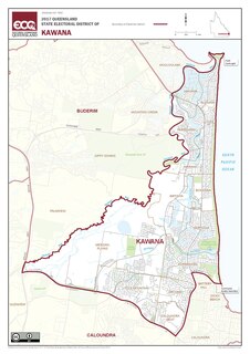
Kawana is an electoral district of the Legislative Assembly in the Australian state of Queensland. Based on the Sunshine Coast, the district has been held by both sides of politics over its short history.

Parrearra, Queensland Suburb of Sunshine Coast, Queensland, Australia

Parrearra is a suburb in the Sunshine Coast Region, Queensland, Australia. In the 2016 census, Parrearra had a population of 4,468 people.

Minyama, Queensland Suburb of Kawana Waters, Queensland, Australia

Minyama is a suburb of Kawana Waters in the Sunshine Coast Region, Queensland, Australia. In the 2016 census, Minyama had a population of 2,542 people.

Warana, Queensland Suburb of Kawana Waters, Queensland, Australia

Warana is a coastal suburb of Kawana Waters in the Sunshine Coast Region, Queensland, Australia. In the 2016 census, Warana had a population of 3,688 people.

Birtinya, Queensland Suburb of Kawana Waters, Queensland, Australia

Birtinya is a suburb of Kawana Waters in the Sunshine Coast Region, Queensland, Australia.

Bokarina, Queensland Suburb of Sunshine Coast, Queensland, Australia

Bokarina is a coastal suburb in the Sunshine Coast Region, Queensland, Australia, located within the Kawana Waters urban centre. In the 2016 census Bokarina had a population of 1,351 people.

Dicky Beach, Queensland Suburb of Caloundra, Queensland, Australia

Dicky Beach is both a beach and coastal suburb of Caloundra in the Sunshine Coast Region, Queensland, Australia. In the 2016 census, Dicky Beach had a population of 1,895 people.

Moffat Beach, Queensland Suburb of Caloundra, Queensland, Australia

Moffat Beach is a coastal suburb in the Sunshine Coast Region, Queensland, Australia. In the 2016 census, Moffat Beach had a population of 2,553 people.

Twin Waters, Queensland Suburb of Maroochydore, Queensland, Australia

Twin Waters is a coastal suburb of Maroochydore in the Sunshine Coast Region, Queensland, Australia. In the 2016 census, Twin Waters had a population of 2,687 people.

Yaroomba, Queensland Suburb of Sunshine Coast, Queensland, Australia

Yaroomba is a coastal suburb in the Sunshine Coast Region, Queensland, Australia. In the 2016 census, Yaroomba had a population of 1623 people.

Aroona, Queensland Suburb of Caloundra, Queensland, Australia

Aroona is a suburb of Caloundra in the Sunshine Coast Region, Queensland, Australia. In the 2016 census, Aroona had a population of 3,287 people.

Pelican Waters, Queensland Suburb of Caloundra, Queensland, Australia

Pelican Waters is a suburb of Caloundra in the Sunshine Coast Region, Queensland, Australia. In the 2016 census, Pelican Waters had a population of 6,277 people.

Glenlee, Queensland Suburb of Livingstone Shire, Queensland, Australia

Glenlee is a rural locality in the Livingstone Shire, Queensland, Australia. In the 2016 census, Glenlee had a population of 1,236 people.

Eli Waters, Queensland Suburb of Fraser Coast Region, Queensland, Australia

Eli Waters is a coastal suburb of Hervey Bay in the Fraser Coast Region, Queensland, Australia. In the 2016 census, Eli Waters had a population of 3,310 people.

Cullinane, Queensland Suburb of Cassowary Coast Region, Queensland, Australia

Cullinane is a rural locality in the Cassowary Coast Region, Queensland, Australia. In the 2016 census, Cullinane had a population of 524 people.

References

  1. 1 2 3 Australian Bureau of Statistics (27 June 2017). "Wurtulla (SSC)". 2016 Census QuickStats. Retrieved 20 October 2018. OOjs UI icon edit-ltr-progressive.svg
  2. 1 2 "Wurtulla – suburb in Sunshine Coast Region (entry 48949)". Queensland Place Names. Queensland Government . Retrieved 19 September 2020.
  3. 1 2 3 4 "Queensland Globe". State of Queensland . Retrieved 13 October 2020.
  4. "Currimundi Lake (Kathleen McArthur) Conservation Park". Department of Environment and Science. Queensland Government. 21 October 2009. Archived from the original on 13 October 2020. Retrieved 13 October 2020.