Peregian Beach, Queensland

Last updated

Peregian Beach
Noosa,  Queensland
Peregian Beach, 2012.jpg
Peregian Beach, 2012
Australia Queensland location map.svg
Red pog.svg
Peregian Beach
Coordinates 26°27′59″S153°03′49″E / 26.4663°S 153.0636°E / -26.4663; 153.0636 Coordinates: 26°27′59″S153°03′49″E / 26.4663°S 153.0636°E / -26.4663; 153.0636
Population3,791 (2016 census) [1]
 • Density451.3/km2 (1,169/sq mi)
Established1960 [2]
Postcode(s) 4573
Area8.4 km2 (3.2 sq mi)
Location
LGA(s)
State electorate(s)
Federal Division(s) Wide Bay
Suburbs around Peregian Beach:
(Lake Weyba) Noosaville Marcus Beach Coral Sea
Doonan Peregian Beach Coral Sea
Peregian Springs Coolum Beach Coral Sea

Peregian Beach is a beach and small coastal town on the Sunshine Coast, Queensland, Australia. [3] [4] It is a suburb split between two local government areas with the eastern coastal in the Shire of Noosa and the western hinterland part in the Sunshine Coast Region. [5] [6] (Between 2008 and 2013 Peregian Beach was entirely within Sunshine Coast Region). In the 2016 census, Peregian Beach had a population of 3,791 people. [1]

Contents

History

Peregian is a Kabi Kabi word for emu or may derive from perridhan/jan meaning mangrove seeds. [7] Nearby Mount Peregian was formerly known as Emu Mountain. [8] [9]

During World War II, Peregian Beach, Sunshine Beach and surrounding areas were used for artillery training. Current residents occasionally discover artillery shells and unexploded ordnance on their land. [10]

In the 2011 census, Peregian Beach had a population of 3,531 people. [11] In the 2016 census, Peregian Beach had a population of 3,791 people. [12]

In 2015, there was a competition for local residents to choose one of four pieces of artwork to decorate the concrete walls of the Peregian Beach Reservoir. [13] The winning artwork was "Peregian Stand" by Peregian artist Colin Passmore which depicted a stand of melaleuca trees. [14]

Geography

Peregian Beach within the Sunshine Coast Region comprises continual residential development along the eastern coastal strip of sandy beaches. The David Low Way passes north to south through this area. Development to the west is constrained by Noosa National Park. [15]

Peregian Beach within the Shire of Noosa is further west, bounded on the north by Lake Weyba and to the east by Noosa National Park and Murdering Creek. Its south-western boundary roughly follows Emu Mountain Road. This area is only sparsely settled. [15]

Amenities

There is a village style shopping precinct, a surf club and hotel. The local skate park is popular amongst skaters in the region, but can be prone to short periods of flash flooding in the wet season.

The town of Peregian Beach has recently been given an upgrade, with a new shopping precinct including several new restaurants, a medical centre, and assorted shops. Several other shops have recently been renovated.

The Shire of Noosa operates a weekly mobile library service on a weekly schedule located on Woodland Drive. [16]

Tourism

Events

Peregian Originals is a popular community event held on the second Sunday of each month in the park beside the Surf Club showcasing original live music.

Peregian Markets is a popular community event held on the first and third Sunday of each month in the park on the beachside of the Surf Club which helps raise money for the local club.

Related Research Articles

Sunshine Coast, Queensland Region in Queensland, Australia

Sunshine Coast is a peri-urban area and the third most populated area in the Australian state of Queensland. Located 100 km (62 mi) north of the centre of Brisbane in South East Queensland, on the Coral Sea coastline, its urban area spans approximately 60 km (37 mi) of coastline and hinterland from Pelican Waters to Tewantin. The estimated urban population of Sunshine Coast as of June 2018 was 333,436, making it the 9th most populous in the country. The population of the area has grown steadily at an average annual rate of 2.4% year-on-year over the five years to 2018.

Noosa Heads, Queensland Town in Queensland, Australia

Noosa Heads is a coastal town and suburb of the Shire of Noosa on the Sunshine Coast, Queensland, Australia. It is located approximately 136 kilometres (85 mi) north of Brisbane, the state's capital.

Shire of Noosa Local government area in Queensland, Australia

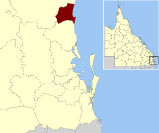
The Shire of Noosa is a local government area about 130 kilometres (81 mi) north of Brisbane in the Sunshine Coast district of South East Queensland, Australia. The shire covers an area of 870 square kilometres (335.9 sq mi). It existed as a local government entity from 1910 until 2008, when it was amalgamated with the Shire of Maroochy and City of Caloundra to form the Sunshine Coast Region. The shire was re-established on 1 January 2014.

Boreen Point, Queensland Suburb of Noosa, Queensland, Australia

Boreen Point is a rural locality in the Shire of Noosa, Queensland, Australia. In the 2016 census, Boreen Point had a population of 328 people. The town of Boreen is located within the locality beside the lake, but the town name is rarely used with Boreen Point being the name in common usage.

Coolum Beach, Queensland Suburb of Sunshine Coast, Queensland, Australia

Coolum Beach is a beachside town and coastal suburb of the Sunshine Coast Region, Queensland, Australia. They take their name from the beach. At the 2016 census, it had a population of 8,497.

Noosaville, Queensland Suburb of Noosa, Queensland, Australia

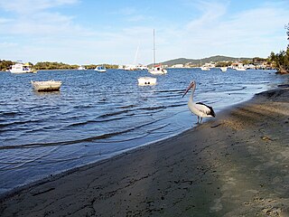
Noosaville is a town and suburb in Noosa in the Shire of Noosa, Queensland, Australia. In the 2016 census, Noosaville had a population of 8,124 people.

Sunshine Beach, Queensland Town in Queensland, Australia

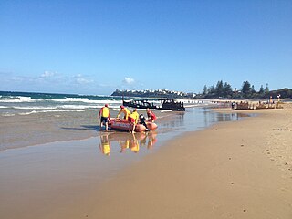
Sunshine Beach is a coastal town and suburb in the Shire of Noosa, Queensland, Australia. In the 2016 census, Sunshine Beach had a population of 2,460 people.

Sunrise Beach, Queensland Suburb of Noosa Heads, Queensland, Australia

Sunrise Beach is a coastal suburb in the Shire of Noosa, Queensland, Australia. In the 2016 census, Sunrise Beach had a population of 3,415 people.

Castaways Beach, Queensland Suburb of Noosa, Queensland, Australia

Castaways Beach is a coastal suburb in the Shire of Noosa, Queensland, Australia. In the 2016 census Castaways Beach had a population of 656 people.

Marcus Beach, Queensland Suburb of Noosa, Queensland, Australia

Marcus Beach is a coastal suburb in the Shire of Noosa, Queensland, Australia.

Cooroibah, Queensland Suburb of Noosa, Queensland, Australia

Cooroibah is a locality in the Shire of Noosa, Queensland, Australia. In the 2016 census, Cooroibah had a population of 2041 people.

Noosa North Shore, Queensland Suburb of Noosa, Queensland, Australia

Noosa North Shore is a coastal rural locality in the Shire of Noosa, Queensland, Australia. In the 2016 census, Noosa North Shore had a population of 179 people.

Ringtail Creek, Queensland Suburb of Shire of Noosa, Queensland, Australia

Ringtail Creek is a rural locality in the Shire of Noosa, Queensland, Australia. In the 2016 census Ringtail Creek had a population of 197 people.

Cooroy Mountain, Queensland Suburb of Sunshine Coast, Queensland, Australia

Cooroy Mountain is a rural locality in the Shire of Noosa, Queensland, Australia. In the 2016 census, Cooroy Mountain had a population of 136 people.

Weyba Downs, Queensland Suburb of Sunshine Coast Region, Queensland, Australia

Weyba Downs is a rural locality in the Sunshine Coast Region, Queensland, Australia. In the 2016 census, Weyba Downs had a population of 296 people.

Dicky Beach, Queensland Suburb of Caloundra, Queensland, Australia

Dicky Beach is both a beach and coastal suburb of Caloundra in the Sunshine Coast Region, Queensland, Australia. In the 2016 census, Dicky Beach had a population of 1,895 people.

Peregian Springs, Queensland Suburb of Sunshine Coast, Queensland, Australia

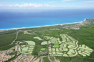
Peregian Springs is a suburb in the Sunshine Coast Region, Queensland, Australia. The suburb is home to a large-scale housing estate of the same name which is being developed by FKP Property Group. At the 2016 census, Peregian Springs had a population of 7,065.

Mount Coolum, Queensland Suburb of Sunshine Coast, Queensland, Australia

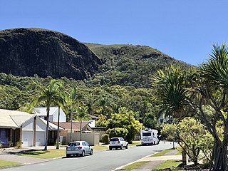
Mount Coolum is a coastal suburb in the Sunshine Coast Region, Queensland, Australia. In the 2016 census, Mount Coolum had a population of 4,265 people.

Yaroomba, Queensland Suburb of Sunshine Coast, Queensland, Australia

Yaroomba is a coastal suburb in the Sunshine Coast Region, Queensland, Australia. In the 2016 census, Yaroomba had a population of 1623 people.

Sunshine Coast Region Local government area in Queensland, Australia

The Sunshine Coast Region is a local government area located in the Sunshine Coast district of South East Queensland, Australia.

References

  1. 1 2 Australian Bureau of Statistics (27 June 2017). "Peregian Beach (SSC)". 2016 Census QuickStats. Retrieved 19 March 2018. OOjs UI icon edit-ltr-progressive.svg
  2. Noosa Shire Historical Cultural Heritage - Marcus & Peregian Beach, July 2002 [ permanent dead link ] 19 December 2006
  3. "Peregian Beach – beach (entry 26445)". Queensland Place Names. Queensland Government . Retrieved 22 December 2015.
  4. "Peregian Beach – town (entry 26446)". Queensland Place Names. Queensland Government . Retrieved 22 December 2015.
  5. "Peregian Beach – suburb (Shire of Noosa) (entry 48836)". Queensland Place Names. Queensland Government . Retrieved 22 December 2015.
  6. "Peregian Beach – suburb (Sunshine Coast Region) (entry 49429)". Queensland Place Names. Queensland Government . Retrieved 22 December 2015.
  7. "Place names of South East Queensland". Archived from the original on 16 August 2008. Retrieved 30 April 2021.
  8. "Mount Peregian – mountain in the Sunshine Coast Region (entry 26448)". Queensland Place Names. Queensland Government . Retrieved 30 April 2021.
  9. "9544-44 Coolum" (Map). Queensland Government. 1981. Retrieved 30 April 2021.
  10. Joyce, Nikkii (27 November 2008). "Don't touch that bomb!". Sunshine Coast Daily. Archived from the original on 11 August 2014. Retrieved 26 June 2014.
  11. Australian Bureau of Statistics (31 October 2012). "Peregian Beach (SSC)". 2011 Census QuickStats. Retrieved 26 June 2014. OOjs UI icon edit-ltr-progressive.svg
  12. Australian Bureau of Statistics (27 June 2017). "Peregian Beach (SSC)". 2016 Census QuickStats. Retrieved 21 September 2019. OOjs UI icon edit-ltr-progressive.svg
  13. "Facelift for a Peregian eyesore paints brighter future". Noosa News . 19 October 2015. Archived from the original on 11 October 2016. Retrieved 5 September 2016.
  14. "Announcing the winning artwork for the Peregian Beach Reservoir". UnityWater. 9 November 2015. Archived from the original on 3 October 2016. Retrieved 5 September 2016.
  15. 1 2 "Queensland Globe". State of Queensland . Retrieved 18 March 2019.
  16. "Noosa Mobile Library - Mobile Stops - Noosa Mobile Hours". Shire of Noosa. Archived from the original on 30 January 2018. Retrieved 19 January 2018.

Further reading