Kureelpa, Queensland

Last updated

Kureelpa
Queensland
Kureelpa QLD 4560, Australia - panoramio.jpg
Kureelpa panorama, 2015
Australia Queensland location map.svg
Red pog.svg
Kureelpa
Coordinates 26°36′24″S152°53′34″E / 26.6066°S 152.8927°E / -26.6066; 152.8927 (Kureelpa (centre of locality))
Population968 (2021 census) [1]
 • Density71.18/km2 (184.3/sq mi)
Postcode(s) 4560
Area13.6 km2 (5.3 sq mi)
Time zone AEST (UTC+10:00)
Location
LGA(s) Sunshine Coast Region
State electorate(s) Nicklin
Federal division(s) Fairfax
Suburbs around Kureelpa:
Gheerulla Kiamba Image Flat
Gheerulla Kureelpa Highworth
Mapleton Dulong Burnside
Perwillowen

Kureelpa is a rural locality in the Sunshine Coast Region, Queensland, Australia. [2] In the 2021 census, Kureelpa had a population of 968 people. [1]

Contents

Geography

Poona Dam is an earth-fill embankment dam with a toe drain with an un-gated spillway across a tributary of the South Maroochy River. [3] [4] The main purpose of the dam is for storage of potable water for the Sunshine Coast region.[ citation needed ]

History

The name Kureelpa is reportedly derived from an Aboriginal name, Kuril-ba, meaning a place of rats and mice. [2]

Kureelpa Provisional School opened on 24 February 1914, becoming Kureelpa State School on 1 June 1916. The school closed on 1 December 1967. [5] It was at 551 Nambour Mapleton Road ( 26°37′05″S152°54′03″E / 26.61797°S 152.90081°E / -26.61797; 152.90081 (Kureelpa State School (former)) ), [6] now the site of the Blackall Range Independent School. [7]

Poona State School opened on 9 November 1915 and closed on 30 June 1933. Despite the name, this school was not located in Poona in the Fraser Coast Region, but "via Nambour", possibly in the vicinity of the Poona Dam in Kureelpa. [8] The first teacher was Ethel Edwards. [9] It closed due to low student numbers in June 1933. [10] The school buildings were sold in 1937. [11]

The Poona Dam was built in 1959. The height of the dam wall was increased in 1969 with upgrades to the spillway in 1998. [4]

Blackall Range Independent School opened on 2 February 1975. [5] It initially occupied the Kureelpa Hall and then moved to the building of the former Kureelpa State School. [7]

Demographics

In the 2016 census, Kureelpa had a population of 907 people. [12]

In the 2021 census, Kureelpa had a population of 968 people. [1]

Education

Blackall Range Independent School is a private primary and secondary (Prep-12) school for boys and girls at 551 Nambour Mapleton Road ( 26°37′04″S152°54′04″E / 26.6178°S 152.9012°E / -26.6178; 152.9012 (Blackall Range Independent School) ). [13] [14] In 2017, the school had an enrolment of 54 students with 8 teachers (6 full-time equivalent) and 11 non-teaching staff (7 full-time equivalent). [15]

There are no government schools in Kureelpa. The nearest government primary schools are Mapleton State School in neighbouring Mapleton to the south-west, Burnside State School in neighbouring Burnside to the south-east, and Nambour State College (junior school) in Nambour to the east. The nearest government secondary schools are Burnside State High School in Burnside and Nambour State College (senior school) in Nambour. [16]

Bushwalks

The 8.5-kilometre (5.3 mi) Kureelpa Falls circuit starts at the Mapleton day-use area trailhead and passes through a gorge and various rockpools. It should be avoided after heavy rains. [17]

Related Research Articles

<span class="mw-page-title-main">Nambour</span> Suburb of Sunshine Coast, Queensland, Australia

Nambour is a rural town and locality in the Sunshine Coast Region, Queensland, Australia. In the 2016 census, the locality of Nambour had a population of 11,187 people.

<span class="mw-page-title-main">Yandina, Queensland</span> Town in Queensland, Australia

Yandina is a rural town and locality in the Sunshine Coast Region, Queensland, Australia. IIn the 2021 census, the locality of Yandina had a population of 3,073 people.

<span class="mw-page-title-main">Shire of Maroochy</span> Local government area in Queensland, Australia

The Shire of Maroochy was a local government area about 100 kilometres (62 mi) north of Brisbane in the Sunshine Coast region of South East Queensland, Australia. The shire covered an area of 1,162.7 square kilometres (448.9 sq mi), and existed as a local government entity from 1890 until 2008, when it amalgamated with its neighbours to the north and south to form the Sunshine Coast Region.

<span class="mw-page-title-main">Mapleton, Queensland</span> Suburb of Sunshine Coast Region, Queensland, Australia

Mapleton is a rural town and locality in the Sunshine Coast Region, Queensland, Australia. In the 2016 census, the locality of Mapleton had a population of 1,564 people.

Montville is a rural town and locality in the Sunshine Coast Region, Queensland, Australia. In the 2016 census, the locality of Montville had a population of 970 people.

<span class="mw-page-title-main">Woombye, Queensland</span> Town in Queensland, Australia

Woombye is a rural town and locality in the Sunshine Coast Region, Queensland, Australia. In the 2021 census, the locality of Woombye had a population of 3,944 people.

Eudlo is a rural town and locality in the Sunshine Coast Region, Queensland, Australia. In the 2016 census, the locality of Eudlo had a population of 1,117 people.

<span class="mw-page-title-main">Ninderry, Queensland</span> Town in Queensland, Australia

Ninderry is a rural town and locality in the Sunshine Coast Region, Queensland, Australia. In the 2016 census, the locality of Ninderry had a population of 1,087 people.

<span class="mw-page-title-main">Burnside, Queensland</span> Suburb of Nambour, Queensland, Australia

Burnside is a residential locality of the town of Nambour in the Sunshine Coast Region, Queensland, Australia. In the 2021 census, Burnside had a population of 3,104 people.

West Woombye is a rural residential locality in the Sunshine Coast Region, Queensland, Australia. In the 2016 census West Woombye had a population of 1,007 people.

The Poona Dam is an earth-fill embankment dam with a toe drain with an un-gated spillway across a tributary of the South Maroochy River in Kureelpa, Sunshine Coast Region, Queensland, Australia. The main purpose of the dam is for storage of potable water for the Sunshine Coast region. The impounded reservoir is also called Poona Dam.

<span class="mw-page-title-main">Blackall Range</span>

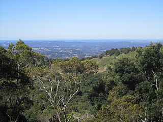
The Blackall Range is a mountain range in South East Queensland, Australia. The first European explorer in the area was Ludwig Leichhardt. It was named after Samuel Blackall, the second Governor of Queensland.

<span class="mw-page-title-main">Maroochy River</span> River in Queensland, Australia

The Maroochy River is a river in South East Queensland, Australia. The river rises from the eastern slopes of the Blackall Range and flows east through Eumundi before entering the sea at Cotton Tree, Maroochydore. Other populated centres in the catchment include Nambour, Eudlo, Yandina and Coolum.

Hunchy is a rural locality in the Sunshine Coast, Queensland, Australia. In the 2021 census, Hunchy had a population of 592 people.

<span class="mw-page-title-main">Obi Obi, Queensland</span> Suburb of Sunshine Coast Region, Queensland, Australia

Obi Obi is a rural locality in the Sunshine Coast Region, Queensland, Australia. In the 2021 census, Obi Obi had a population of 208 people.

<span class="mw-page-title-main">Flaxton, Queensland</span> Suburb of Sunshine Coast Region, Queensland, Australia

Flaxton is a rural locality in the Sunshine Coast Region, Queensland, Australia. In the 2021 census, Flaxton had a population of 992 people.

<span class="mw-page-title-main">Dulong, Queensland</span> Suburb of Sunshine Coast Region, Queensland, Australia

Dulong is a rural locality in the Sunshine Coast Region, Queensland, Australia. In the 2021 census, Dulong had a population of 688 people.

Perwillowen is a rural locality in the Sunshine Coast Region, Queensland, Australia. In the 2021 census, Perwillowen had a population of 213 people.

<span class="mw-page-title-main">Kiamba, Queensland</span> Suburb of Sunshine Coast Region, Queensland, Australia

Kiamba is a rural locality in the Sunshine Coast Region, Queensland, Australia. In the 2021 census, Kiamba had a population of 191 people.

Blackall Range road network is a group of roads that provide access to the mountain localities and towns from various lowland places, and enable travel between the mountain communities. The network ensures continuity of access in times of flooding or other natural disasters, and during planned maintenance activities. The area serviced by the network includes the localities and towns, from south to north, of Maleny, Montville and Mapleton. It also includes the rural localities of Bald Knob, Balmoral Ridge, Flaxton, Gheerulla, North Maleny, Obi Obi and Witta. The area hosts a substantial residential community plus many tourism accommodation venues. At the 2021 census, the locality of Maleny had a population of 3,959 people.

References

  1. 1 2 3 Australian Bureau of Statistics (28 June 2022). "Kureelpa (SAL)". 2021 Census QuickStats. Retrieved 28 February 2023. OOjs UI icon edit-ltr-progressive.svg
  2. 1 2 "Kureelpa – locality in Sunshine Coast Region (entry 48715)". Queensland Place Names. Queensland Government . Retrieved 22 December 2018.
  3. "Poona Dam – reservoir in the Sunshine Coast Region (entry 49658)". Queensland Place Names. Queensland Government . Retrieved 26 July 2020.
  4. 1 2 "Poona Dam". Seqwater . Archived from the original on 17 March 2020. Retrieved 26 July 2020.
  5. 1 2 Queensland Family History Society (2010), Queensland schools past and present (Version 1.01 ed.), Queensland Family History Society, ISBN   978-1-921171-26-0
  6. "Parish of Maroochy sheet 2" (Map). Queensland Government. 1955. Retrieved 10 August 2023.
  7. 1 2 "Our History". Blackall Range Independent School. Archived from the original on 24 April 2019. Retrieved 24 April 2019.
  8. "Advertising". The Brisbane Courier . No. 17, 881. Queensland, Australia. 8 May 1915. p. 1. Archived from the original on 10 August 2023. Retrieved 9 November 2019 via National Library of Australia.
  9. "Family Notices". Nambour Chronicle And North Coast Advertiser . No. 1981. Queensland, Australia. 29 May 1942. p. 5. Archived from the original on 10 August 2023. Retrieved 9 November 2019 via National Library of Australia.
  10. "YANDINA". The Brisbane Courier . No. 23, 534. Queensland, Australia. 5 July 1933. p. 14. Archived from the original on 10 August 2023. Retrieved 26 July 2020 via National Library of Australia.
  11. "POONA STATE SCHOOL BUILDINGS PURCHASED". Nambour Chronicle And North Coast Advertiser . Vol. XXXI, no. 1723. Queensland, Australia. 11 June 1937. p. 5. Archived from the original on 10 August 2023. Retrieved 9 November 2019 via National Library of Australia.
  12. Australian Bureau of Statistics (27 June 2017). "Kureelpa (SSC)". 2016 Census QuickStats. Retrieved 20 October 2018. OOjs UI icon edit-ltr-progressive.svg
  13. "State and non-state school details". Queensland Government. 9 July 2018. Archived from the original on 21 November 2018. Retrieved 21 November 2018.
  14. "Blackall Range Independent School". Archived from the original on 26 February 2019. Retrieved 21 November 2018.
  15. "ACARA School Profile 2017". Archived from the original on 22 November 2018. Retrieved 22 November 2018.
  16. "Queensland Globe". State of Queensland . Retrieved 10 August 2023.
  17. "Tips For Kureelpa Falls". 27 November 2022. Archived from the original on 15 March 2023. Retrieved 15 March 2023.

Commons-logo.svg Media related to Kureelpa, Queensland at Wikimedia Commons