Gheerulla

Last updated

Gheerulla
Queensland
Australia Queensland location map.svg
Red pog.svg
Gheerulla
Coordinates 26°34′35″S152°48′53″E / 26.5763°S 152.8147°E / -26.5763; 152.8147 (Gheerulla (centre of locality))
Population291 (2021 census) [1]
 • Density3.237/km2 (8.384/sq mi)
Postcode(s) 4574
Area89.9 km2 (34.7 sq mi)
Time zone AEST (UTC+10:00)
LGA(s) Sunshine Coast Region
State electorate(s) Nicklin
Federal division(s) Fairfax
Suburbs around Gheerulla:
Moy Pocket Belli Park Cooloolabin
Kenilworth Gheerulla Kiamba
Coolabine Obi Obi
Mapleton
Kureelpa

Gheerulla is a rural locality in the Sunshine Coast Region, Queensland, Australia. [2] In the 2021 census, Gheerulla had a population of 291 people. [1]

Contents

Geography

Much of the locality is within the Mapleton National Park, which extends into neighbouring Belli Park, Cooloolabin, and beyond. [3] The Blackall Range ( 26°36′25″S152°52′22″E / 26.6070°S 152.8728°E / -26.6070; 152.8728 (Blackall Range) ) runs through the east and north-east of the locality within the national park. [3]

Gheerulla has the following mountains and cliffs:

History

Gheerulla is an Aboriginal word meaning empty creek. [8]

The Blackall Range was named in 1868 by Edward Parker Bedwell, a hydrographic surveyor in the Royal Navy, after the Governor of Queensland Samuel Wensley Blackall. [9]

St Matthew's Anglican Church was dedicated on 28 June 1926 by Archbishop Gerald Sharp. 200 people attended the opening. [10] Its closure circa 2015 was approved by Bishop Jonathan Holland. [11] The church was at 2210 Eumundi Kenilworth Road ( 26°33′23″S152°46′22″E / 26.5563°S 152.7729°E / -26.5563; 152.7729 (St Matthew's Anglican Church (former)) ) on a 0.4-hectare (0.99-acre) site. It was sold on 14 March 2016 for $210,000. [12]

Demographics

In the 2016 census, Gheerulla had a population of 214 people. [13]

In the 2021 census, Gheerulla had a population of 291 people. [1]

Attractions

There are a number of lookouts in Gheerulla.

Gheerulla Valley Viewpoint is a lookout ( 26°35′45″S152°48′46″E / 26.5958°S 152.8127°E / -26.5958; 152.8127 (Gheerulla Valley Viewpoint) ). [8]

Oaky Creek Lookout is a lookout ( 26°33′20″S152°48′01″E / 26.5555°S 152.8002°E / -26.5555; 152.8002 (Oaky Creek Lookout) ). The name is presumed to refer to nearby Oaky Creek. [14]

Thilba Thalba Viewpoint is a lookout ( 26°34′46″S152°47′21″E / 26.5794°S 152.7891°E / -26.5794; 152.7891 (Thilba Thalba Viewpoint) ). The name was suggested by the Sunshine Coast Environment Council as part of the Great Walk Project believed to have been found on an old map and probably of Aboriginal origin. [15]

Ubajee Viewpoint is a lookout ( 26°36′23″S152°49′55″E / 26.6063°S 152.8319°E / -26.6063; 152.8319 (Ubajee Viewpoint) ). Ubajee is an Aboriginal word in the Gubbi Gubbi and Butchulla languages meaning home. It is pronounced yu'ba'djee. [16]

The rugged Sunshine Coast Hinterland Great Walk takes at least four days to complete. It leaves from Baroon Pocket Dam and traverses 58.8 kilometres (36.5 mi) through the Blackall Range. Sections 2, 3 and 4 of the Great Walk pass through this area. [17]

See also

Related Research Articles

<span class="mw-page-title-main">Noosa Heads, Queensland</span> Suburb of Noosa, Queensland, Australia

Noosa Heads is a coastal town and suburb in the Shire of Noosa, Queensland, Australia. In the 2021 census, the suburb of Noosa Heads had a population of 5,120 people. It is a popular holiday destination.

<span class="mw-page-title-main">Maleny, Queensland</span> Town in Queensland, Australia

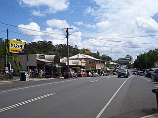
Maleny is a rural town and locality in the Sunshine Coast Region, Queensland, Australia. Maleny was a timber town until the early 1920s and then was a centre of dairy production and fruit growing. In the 2021 census, the locality of Maleny had a population of 3,959 people.

<span class="mw-page-title-main">Landsborough, Queensland</span> Town in Queensland, Australia

Landsborough is a town and a locality in the Sunshine Coast Region, Queensland, Australia. At the 2021 census, Landsborough had a population of 4,446 people.

<span class="mw-page-title-main">Beerwah, Queensland</span> Suburb of Sunshine Coast, Queensland, Australia

Beerwah is a rural town and locality in the hinterland of the Sunshine Coast Region, Queensland, Australia. At the 2021 census, the locality of Beerwah had a population of 7,734 people.

<span class="mw-page-title-main">Eumundi, Queensland</span> Town in Queensland, Australia

Eumundi is a rural town and locality in the Sunshine Coast Region, Queensland, Australia. In the 2021 census, the locality of Eumundi had a population of 2,504 people.

Montville is a rural town and locality in the Sunshine Coast Region, Queensland, Australia. In the 2016 census, the locality of Montville had a population of 970 people.

<span class="mw-page-title-main">Woombye, Queensland</span> Town in Queensland, Australia

Woombye is a rural town and locality in the Sunshine Coast Region, Queensland, Australia. In the 2021 census, the locality of Woombye had a population of 3,944 people.

Doonan is a rural residential locality split between the Sunshine Coast Region and the Shire of Noosa, both in Queensland, Australia. In the 2021 census, Doonan had a population of 3,727 people.

Verrierdale is a rural locality in the Sunshine Coast Region, Queensland, Australia. In the 2021 census, Verrierdale had a population of 809 people.

<span class="mw-page-title-main">Eerwah Vale, Queensland</span> Suburb of Sunshine Coast, Queensland, Australia

Eerwah Vale is a locality split between the Sunshine Coast Region and Shire of Noosa, both in Queensland, Australia. In the 2021 census, Eerwah Vale had a population of 671 people.

North Arm is a rural town and locality in the Sunshine Coast Region, Queensland, Australia. In the 2021 census, the locality of North Arm had a population of 734 people.

<span class="mw-page-title-main">Burnside, Queensland</span> Suburb of Nambour, Queensland, Australia

Burnside is a residential locality of the town of Nambour in the Sunshine Coast Region, Queensland, Australia. In the 2021 census, Burnside had a population of 3,104 people.

West Woombye is a rural residential locality in the Sunshine Coast Region, Queensland, Australia. In the 2016 census West Woombye had a population of 1,007 people.

<span class="mw-page-title-main">Baroon Pocket Dam</span> Dam in South East Queensland

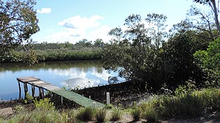
The Baroon Pocket Dam is a rock and earth-fill embankment dam with an un-gated spillway across the Obi Obi Creek, in North Maleny, Sunshine Coast Region, in South East Queensland, Australia. The main purpose of the dam is for potable water supply. The impounded reservoir is called Lake Baroon.

<span class="mw-page-title-main">Coochin Creek</span> Suburb of Sunshine Coast, Queensland, Australia

Coochin Creek is a coastal locality in the south of the Sunshine Coast Region, Queensland, Australia. The locality is named for the creek which flows through it.

<span class="mw-page-title-main">Obi Obi, Queensland</span> Suburb of Sunshine Coast Region, Queensland, Australia

Obi Obi is a rural locality in the Sunshine Coast Region, Queensland, Australia. In the 2021 census, Obi Obi had a population of 208 people.

Bald Knob is a rural locality in the Sunshine Coast Region, Queensland, Australia. At the 2021 census, Bald Knob had a population of 280 people.

<span class="mw-page-title-main">Balmoral Ridge, Queensland</span> Suburb of Sunshine Coast, Queensland, Australia

Balmoral Ridge is a rural locality in the Sunshine Coast Region, Queensland, Australia. At the 2021 census, Balmoral Ridge had a population of 302 people.

Coolabine is a rural locality in the Sunshine Coast Region, Queensland, Australia. In the 2021 census, Coolabine had a population of 76 people.

<span class="mw-page-title-main">Wootha, Queensland</span> Suburb of Sunshine Coast Region, Queensland, Australia

Wootha is a rural locality in the Sunshine Coast Region, Queensland, Australia. In the 2016 census Wootha had a population of 201 people.

References

  1. 1 2 3 Australian Bureau of Statistics (28 June 2022). "Gheerulla (SAL)". 2021 Census QuickStats. Retrieved 28 February 2023. OOjs UI icon edit-ltr-progressive.svg
  2. "Gheerulla – locality in Sunshine Coast Region (entry 48647)". Queensland Place Names. Queensland Government . Retrieved 29 December 2020.
  3. 1 2 "Queensland Globe". State of Queensland . Retrieved 31 December 2020.
  4. "Mountain peaks and capes - Queensland". Queensland Open Data. Queensland Government. 12 November 2020. Archived from the original on 25 November 2020. Retrieved 25 November 2020.
  5. "Mount Thilba Thalba – mountain in Sunshine Coast Region (entry 39759)". Queensland Place Names. Queensland Government . Retrieved 25 November 2020.
  6. "Gheerulla Bluff – cliff in Sunshine Coast Regional (entry 49654)". Queensland Place Names. Queensland Government . Retrieved 29 December 2020.
  7. "Rocky Bluff – cliff in Sunshine Coast Regional (entry 49049)". Queensland Place Names. Queensland Government . Retrieved 29 December 2020.
  8. 1 2 "Gheerulla Valley Viewpoint – lookout in Sunshine Coast Regional (entry 49655)". Queensland Place Names. Queensland Government . Retrieved 29 December 2020.
  9. "Blackall Range – range in Sunshine Coast Regional (entry 2971)". Queensland Place Names. Queensland Government . Retrieved 29 December 2020.
  10. "CHURCH DEDICATED". Daily Mail . No. 7591. Queensland, Australia. 29 June 1926. p. 8. Archived from the original on 25 February 2022. Retrieved 25 February 2019 via National Library of Australia.
  11. "Closed Churches". Anglican Church Southern Queensland. Archived from the original on 3 April 2019. Retrieved 25 February 2019.
  12. "2210 Eumundi Kenilworth Road, Gheerulla, Qld 4574". Realestate.com.au . Retrieved 25 February 2022.
  13. Australian Bureau of Statistics (27 June 2017). "Gheerulla (SSC)". 2016 Census QuickStats. Retrieved 20 October 2018. OOjs UI icon edit-ltr-progressive.svg
  14. "Oaky Creek Lookout – lookout in Sunshine Coast Regional (entry 49657)". Queensland Place Names. Queensland Government . Retrieved 29 December 2020.
  15. "Thilba Thalba Viewpoint – lookout in Sunshine Coast Regional (entry 49659)". Queensland Place Names. Queensland Government . Retrieved 29 December 2020.
  16. "Ubajee Viewpoint – lookout in Sunshine Coast Regional (entry 49661)". Queensland Place Names. Queensland Government . Retrieved 29 December 2020.
  17. Department of Environment and Science (15 January 2010). "Walking | Sunshine Coast Hinterland Great Walk". Parks and forests | Department of Environment and Science, Queensland. Queensland Government . Retrieved 3 October 2022.