Battery Hill, Queensland

Last updated

Map all coordinates using: OpenStreetMap  
Download coordinates as: KML
Battery Hill
Caloundra,  Queensland
Australia Queensland location map.svg
Red pog.svg
Battery Hill
Coordinates 26°46′45″S153°07′45″E / 26.7791°S 153.1291°E / -26.7791; 153.1291 (Battery Hill (centre of suburb)) Coordinates: 26°46′45″S153°07′45″E / 26.7791°S 153.1291°E / -26.7791; 153.1291 (Battery Hill (centre of suburb))
Population2,536 (2016 census) [1]
 • Density2,820/km2 (7,300/sq mi)
Postcode(s) 4551
Elevation10 to 28 m (33 to 92 ft)
Area0.9 km2 (0.3 sq mi)
Time zone AEST (UTC+10:00)
Location
LGA(s) Sunshine Coast Region
County Canning
Parish Bribie
State electorate(s) Caloundra
Federal division(s) Fisher
Suburbs around Battery Hill:
Currimundi Currimundi Currimundi
Aroona Battery Hill Dicky Beach
Aroona Caloundra Dicky Beach

Battery Hill is a suburb of Caloundra in the Sunshine Coast Region, Queensland, Australia. [2] In the 2016 census, Battery Hill had a population of 2,536 people. [1]

Contents

Geography

Battery Hill is 4 kilometres (2 mi) north of Caloundra.[ citation needed ]

The suburb is bounded to the north by Buderim Road, to the east by Coonowrin Drive, to the south by Cooroora Street, and to the west by the Nicklin Way. [3]

Battery Hill is a hill in the south-east of the locality ( 26°46′52″S153°07′47″E / 26.7810°S 153.1298°E / -26.7810; 153.1298 (Battery Hill) ) at 28 metres (92 ft) above sea level. [4] [5]

History

In the 2011 census, Battery Hill recorded a population of 2,588 people, 53.1% female and 46.9% male. The median age of the Battery Hill population was 40 years, 3 years above the national median of 37. 78.7% of people living in Battery Hill were born in Australia. The other top responses for country of birth were New Zealand 5%, England 3.9%, South Africa 0.8%, United States of America 0.8%, Netherlands 0.6%. 92.3% of people spoke only English at home; the next most common languages were 0.3% Dutch, 0.3% German, 0.3% Portuguese, 0.3% Greek, 0.3% Spanish.[ citation needed ]

In the 2016 census Battery Hill had a population of 2,536 people. [1]

Education

There are no schools in Battery Hill. The nearest government primary schools are Currimundi State School in neighbouring Currimundi to the north-east and Talara Primary College also in Currimundi but to the north-west. The nearest government secondary schools are Caloundra State High School in neighbouring Caloundra to the south and Meridan State College in Meridan Plains to the west. [3]

Amenities

There are a number of parks in the suburb, including:

Related Research Articles

Noosa Heads, Queensland Town in Queensland, Australia

Noosa Heads is a coastal town and suburb in the Shire of Noosa, Queensland, Australia. In the 2016 census, the suburb of Noosa Heads had a population of 4,484 people. It is a popular holiday destination.

Seven Hills, Queensland Suburb of Brisbane, Queensland, Australia

Seven Hills is a suburb in the City of Brisbane, Queensland, Australia. In the 2016 census, Seven Hills had a population of 2,211 people.

Nicklin Way (SR6) is a major road in Sunshine Coast, Queensland, Australia. It is named after former Queensland Premier Frank Nicklin, who opened the road on 5 June 1965. It runs from the southern end of the Sunshine Motorway at Mooloolaba in the north to Caloundra in the south, with the route signed as State Route 6. With the population of Sunshine Coast growing quickly, the road is often prone to congestion.

Currimundi, Queensland Suburb of Caloundra, Queensland, Australia

Currimundi is a coastal suburb of Caloundra in the Sunshine Coast Region, Queensland, Australia. In the 2016 census, Currimundi had a population of 6,786 people.

City of Caloundra Local government area in Queensland, Australia

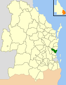
The City of Caloundra was a local government area about 90 kilometres (56 mi) north of Brisbane in the Sunshine Coast region of South East Queensland, Australia. The shire covered an area of 1,093.1 square kilometres (422.0 sq mi); it existed as a local government entity from 1912 until 2008, when it amalgamated with councils further north to form the Sunshine Coast Region.

Birtinya, Queensland Suburb of Kawana Waters, Queensland, Australia

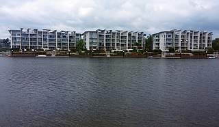
Birtinya is a suburb of Kawana Waters in the Sunshine Coast Region, Queensland, Australia. In the 2016 census Birtinya had a population of 1,933 people.

Dicky Beach, Queensland Suburb of Caloundra, Queensland, Australia

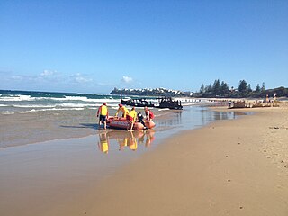
Dicky Beach is both a beach and coastal suburb of Caloundra in the Sunshine Coast Region, Queensland, Australia. In the 2016 census, Dicky Beach had a population of 1,895 people.

Shelly Beach, Queensland (Sunshine Coast) Suburb of Caloundra, Queensland, Australia

Shelly Beach is a coastal suburb of Caloundra in the Sunshine Coast Region, Queensland, Australia. In the 2016 census, Shelly Beach had a population of 854 people.

Kings Beach, Queensland Suburb of Caloundra, Queensland, Australia

Kings Beach is a coastal suburb of Caloundra in the Sunshine Coast Region, Queensland, Australia, located directly east of Caloundra CBD. In the 2016 census, Kings Beach had a population of 2,788 people.

Rowes Bay, Queensland Suburb of Townsville, Queensland, Australia

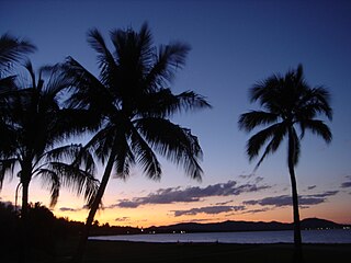
Rowes Bay is a suburb of Townsville in the City of Townsville, Queensland, Australia. In the 2016 census, Rowes Bay had a population of 573 people.

Aroona is a suburb of Caloundra in the Sunshine Coast Region, Queensland, Australia. In the 2016 census, Aroona had a population of 3,287 people.

Golden Beach, Queensland Suburb of Caloundra, Queensland, Australia

Golden Beach is a coastal suburb of Caloundra in the Sunshine Coast Region, Queensland, Australia. It is located within the Caloundra urban centre directly southwest of the Caloundra CBD. In the 2016 census, Golden Beach had a population of 5,575 people.

Glenview is a rural locality in the Sunshine Coast Region, Queensland, Australia. In the 2016 census, Glenview had a population of 1,187 people.

Meridan Plains is a locality on the north-western edge of the Caloundra urban area in the Sunshine Coast Region, Queensland, Australia. Traditionally a rural area, the locality is attracting residential development from the expansion of Caloundra. In the 2016 census, Meridan Plains had a population of 3,675 people.

Caloundra (suburb) Suburb of Sunshine Coast, Queensland, Australia

Caloundra is a coastal suburb and the central business district of the town of Caloundra in the Sunshine Coast Region, Queensland, Australia. In the 2016 census, the suburb of Caloundra had a population of 3,917 people.

Caloundra West, Queensland Suburb of Caloundra, Queensland, Australia

Caloundra West is a mixed-use suburb of Caloundra in the Sunshine Coast Region, Queensland, Australia. In the 2016 census Caloundra West had a population of 6,297 people.

Pelican Waters, Queensland Suburb of Caloundra, Queensland, Australia

Pelican Waters is a suburb of Caloundra in the Sunshine Coast Region, Queensland, Australia. In the 2016 census, Pelican Waters had a population of 6,277 people.

Corbould Park is a locality in the Sunshine Coast Region, Queensland, Australia.

Nirimba, Queensland Suburb of Sunshine Coast Region, Queensland, Australia

Nirimba is a new locality in the Sunshine Coast Region, Queensland, Australia. It was created in 2019.

References

  1. 1 2 3 Australian Bureau of Statistics (27 June 2017). "Battery Hill (SSC)". 2016 Census QuickStats. Retrieved 20 October 2018. OOjs UI icon edit-ltr-progressive.svg
  2. "Battery Hill – suburb in Sunshine Coast Region (entry 48517)". Queensland Place Names. Queensland Government . Retrieved 29 December 2020.
  3. 1 2 "Queensland Globe". State of Queensland . Retrieved 1 April 2021.
  4. "Mountain peaks and capes – Queensland". Queensland Open Data. Queensland Government. 12 November 2020. Archived from the original on 25 November 2020. Retrieved 25 November 2020.
  5. "Battery Hill – mountain in Sunshine Coast Region (entry 1855)". Queensland Place Names. Queensland Government . Retrieved 25 November 2020.
  6. 1 2 3 4 5 6 "Land for public recreation – Queensland". Queensland Open Data. Queensland Government. 20 November 2020. Archived from the original on 22 November 2020. Retrieved 22 November 2020.