County of Canning

Last updated

Canning
Queensland
Canning-county-queensland.png
Location within Queensland
Lands administrative divisions around Canning:
Fitzroy Lennox March
Cavendish Canning Coral Sea
Cavendish Stanley Coral Sea
Map all coordinates using: OpenStreetMap

The County of Canning is a county (a cadastral division) in Queensland, Australia. [1] The county consists of almost all of the former Shires of Caboolture, Maroochy and Kilcoy and the former City of Caloundra. Its main urbanised areas are centred on the Sunshine Coast (excluding Noosa) and the areas surrounding Caboolture. [2]

Contents

History

Canning was first created by an Order in Council by the Governor of New South Wales on 30 December 1848. [3] It was named in honour of Sir George Canning, who had served as British Foreign Secretary and briefly as Prime Minister. [1] The county was then described in the following terms:

County of Canning, containing about 1330 square miles. Bounded on the east by the sea-coast from the 27th parallel of south latitude to the river Maroochydore (sic), including part of Bribie Island and other islands within these limits; on the north by the Maroochy river to its source, thence by the range dividing the waters from the river Mary from those of the Brisbane to Jimna at the source of the Brisbane; on the south-west by the river Brisbane until it reaches the 27th parallel of south latitude; and on the south by the 27th parallel of south latitude, which is the northern boundary of the present reputed county of Stanley.

On 7 March 1901, the Governor of Queensland proclaimed new boundaries under the Land Act 1897. [4] The south boundary was altered from the 27th parallel to the Caboolture River while the north boundary was extended to the Shire of Noosa boundary.

Bounded on the south by the county of Stanley; [5] on the west by the Brisbane River and the parish of Monsildale; on the north by the parishes of Monsildale, Kilcoy and Durundur; again on the west by the west boundaries of the parishes of Bribie and Maroochy; again on north by the north boundary of the parish of Maroochy; and on the east by the Pacific Ocean,—including Bribie Island.

Parishes

Canning is divided into parishes, as listed below:

Parish LGA CoordinatesTowns
Beerwah Sunshine Coast 26°56′S152°58′E / 26.933°S 152.967°E / -26.933; 152.967 (Beerwah Parish) Beerwah, Beerburrum
Bowman Somerset 27°05′S152°33′E / 27.083°S 152.550°E / -27.083; 152.550 (Bowman Parish) Somerset Dam, Hazeldean
Bribie Sunshine Coast 26°49′S153°00′E / 26.817°S 153.000°E / -26.817; 153.000 (Bribie Parish) Caloundra, Landsborough
Canning Moreton Bay 27°03′S152°57′E / 27.050°S 152.950°E / -27.050; 152.950 (Canning Parish) Caboolture, Elimbah
Cressbrook Somerset 27°03′S152°27′E / 27.050°S 152.450°E / -27.050; 152.450 (Cressbrook Parish)
Durundur Moreton Bay 26°54′S152°47′E / 26.900°S 152.783°E / -26.900; 152.783 (Durundur Parish) Woodford
Kilcoy Somerset 26°52′S152°34′E / 26.867°S 152.567°E / -26.867; 152.567 (Kilcoy Parish) Kilcoy
Maroochy Sunshine Coast 26°33′S153°00′E / 26.550°S 153.000°E / -26.550; 153.000 (Maroochy Parish) Nambour, Eumundi, Coolum
Monsildale Somerset 26°39′S152°22′E / 26.650°S 152.367°E / -26.650; 152.367 (Monsildale Parish)
Mooloolah Sunshine Coast 26°40′S153°00′E / 26.667°S 153.000°E / -26.667; 153.000 (Mooloolah Parish) Maroochydore, Eudlo, Sippy Downs
Neara Somerset 26°54′S152°24′E / 26.900°S 152.400°E / -26.900; 152.400 (Neara Parish)
Toorbul Moreton Bay 27°05′S153°05′E / 27.083°S 153.083°E / -27.083; 153.083 (Toorbul Parish) Toorbul, Ningi
Wararba Moreton Bay 27°03′S152°51′E / 27.050°S 152.850°E / -27.050; 152.850 (Waraba Parish) Wamuran
Woorim Moreton Bay 26°58′S153°07′E / 26.967°S 153.117°E / -26.967; 153.117 (Woorim Parish) Bribie Island

Related Research Articles

<span class="mw-page-title-main">Sunshine Coast, Queensland</span> Region in Queensland, Australia

The Sunshine Coast is a peri-urban region in South East Queensland, Australia. It is the district defined in 1967 as "the area contained in the Shires of Landsborough, Maroochy and Noosa, but excluding Bribie Island". Located 100 km (62 mi) north of the centre of Brisbane in South East Queensland, on the Coral Sea coastline, its urban area spans approximately 60 km (37 mi) of coastline and hinterland from Pelican Waters to Tewantin.

<span class="mw-page-title-main">Caboolture railway station</span> Railway station in Queensland, Australia

Caboolture railway station is located on the North Coast line in Queensland, Australia. It serves the urban centre of Caboolture in the City of Moreton Bay.

<span class="mw-page-title-main">Caboolture, Queensland</span> Suburb of City of Moreton Bay, Queensland, Australia

Caboolture is a town and suburb in the City of Moreton Bay, Queensland, Australia. In the 2021 census, the suburb of Caboolture had a population of 29,534 people. It is located on the northern side of the Caboolture River.

<span class="mw-page-title-main">D'Aguilar Highway</span> Highway in Queensland, Australia

The D'Aguilar Highway is a two-lane highway linking the Bruce Highway near Caboolture with the Bunya Highway in Kingaroy in the state of Queensland, Australia. Major towns along the route include Woodford, Kilcoy, Blackbutt, Yarraman, and Nanango. The highway is approximately 164 km (102 mi) in length. The D'Aguilar Highway's highest elevation along its length is 527 m just north of Yarraman, and the lowest point is at 26.8 m just west of Caboolture.

<span class="mw-page-title-main">Kilcoy, Queensland</span> Town in Queensland, Australia

Kilcoy is a rural town and locality in the Somerset Region, Queensland, Australia. In the 2016 census, the locality of Kilcoy had a population of 1,898 people.

<span class="mw-page-title-main">Shire of Maroochy</span> Local government area in Queensland, Australia

The Shire of Maroochy was a local government area about 100 kilometres (62 mi) north of Brisbane in the Sunshine Coast region of South East Queensland, Australia. The shire covered an area of 1,162.7 square kilometres (448.9 sq mi), and existed as a local government entity from 1890 until 2008, when it amalgamated with its neighbours to the north and south to form the Sunshine Coast Region.

<span class="mw-page-title-main">County of Stanley, Queensland</span> Cadastral in Queensland, Australia

The County of Stanley is a cadastral division centred on the city of Brisbane in Queensland, Australia, that is used mainly for the purpose of registering land titles. It was named after Edward Stanley, who was three times British prime minister in the 1850s and 1860s. It is bounded by the Logan River in the south, the Brisbane River at what is now Lake Wivenhoe in the west, the Stanley River at what is now Lake Somerset in the north-west, and Caboolture River in the north. It includes Moreton Island and Stradbroke Island, and extends west to Ipswich's CBD, south to Loganlea and north to Morayfield.

<span class="mw-page-title-main">County of Ward, Queensland</span> Cadastral in Queensland, Australia

The County of Ward is a county in the south-eastern corner of Queensland, Australia. The main urban area within the county is the city of the Gold Coast, and it also extends to include the southern parts of the West Moreton region centred on Beaudesert and Boonah.

<span class="mw-page-title-main">Woodford, Queensland</span> Town in Queensland, Australia

Woodford is a rural town and locality in the City of Moreton Bay, Queensland, Australia. In the 2016 census, the locality of Woodford had a population of 3,458 people.

<span class="mw-page-title-main">Shire of Caboolture</span> Local government area in Queensland

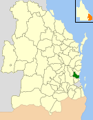
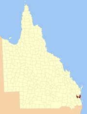
The Shire of Caboolture was a local government area located in the Australian state of Queensland on the northern urban fringe of the capital, Brisbane, and south of the Sunshine Coast. The Shire covered an area of 1,224.4 square kilometres (472.7 sq mi), of which approximately one-quarter was urban, and existed as a local government entity from 1879 until 2008, when it amalgamated with the City of Redcliffe and Shire of Pine Rivers to form the Moreton Bay Region, which was renamed the City of Moreton Bay in July 2023.

<span class="mw-page-title-main">City of Redcliffe</span> Local government area in Queensland, Australia

The City of Redcliffe is a former local government area in South East Queensland, Australia. In 2008 it was amalgamated with the Shires of Pine Rivers and Caboolture to create Moreton Bay Region, later renamed City of Moreton Bay. It is in the northern part of the County of Stanley, with a total area of 38.1 square kilometres (14.7 sq mi) and a population of 51,174 in the 2006 census.

<span class="mw-page-title-main">City of Moreton Bay</span> Local government area in Queensland, Australia

The City of Moreton Bay, known until July 2023 as the Moreton Bay Region, is a local government area in the north of the Brisbane metropolitan city in South East Queensland, Australia. Established in 2008, it replaced three established local government areas, the City of Redcliffe and the Shires of Pine Rivers and Caboolture.

<span class="mw-page-title-main">Somerset Region</span> Local government area in Queensland, Australia

The Somerset Region is a local government area located in the West Moreton region of South East Queensland, Australia, about 100 kilometres (62 mi) northwest of Brisbane and centred on the town of Esk. It was created in 2008 from a merger of the Shire of Esk and the Shire of Kilcoy. It is commonly known as the Brisbane Valley, due to the Brisbane River which courses through the region, although significant parts of the region lie outside the hydrological Brisbane Valley itself.

<span class="mw-page-title-main">County of March</span> Cadastral in Queensland, Australia

The County of March is a county in Queensland, Australia. The county consists of the Noosa area, plus the eastern parts of the Gympie and Fraser Coast regions.

<span class="mw-page-title-main">Woorim, Queensland</span> Suburb of Bribie Island, Queensland, Australia

Woorim is a town and suburb of Bribie Island in the City of Moreton Bay, Queensland, Australia. In the 2016 census, Woorim had a population of 1,829 people.

Jimna is a rural town and locality in the Somerset Region, Queensland, Australia. In the 2016 census, the locality of Jimna had a population of 91 people.

<span class="mw-page-title-main">Rocksberg</span> Suburb of City of Moreton Bay, Queensland, Australia

Rocksberg is a rural locality in the City of Moreton Bay, Queensland, Australia. In the 2016 census, Rocksberg had a population of 300 people.

<i>Dayboro Times and Moreton Mail</i>

Dayboro Times and Moreton Mail was a weekly English language newspaper published in Dayboro, Queensland, Australia.

<span class="mw-page-title-main">Winya, Queensland</span> Suburb of Somerset Region, Queensland, Australia

Winya is a rural locality in the Somerset Region, Queensland, Australia. In the 2016 census, Winya had a population of 72 people.

Caboolture–Bribie Island Road is a continuous 19.2 kilometres (11.9 mi) road route in the City of Moreton Bay, Queensland, Australia. The route is designated as part of State Route 85. It is a state-controlled district road rated as a local road of regional significance (LRRS).

References

  1. 1 2 "Canning (county) (entry 6060)". Queensland Place Names. Queensland Government . Retrieved 1 September 2015.
  2. Moreton District, County of Canning Maps - A2 Series at Queensland Archives.
  3. "The New Counties". The Moreton Bay Courier . Brisbane: National Library of Australia. 13 January 1849. p. 4. Retrieved 19 June 2013.
  4. "A Proclamation". Queensland Government Gazette. Vol. 75. 8 March 1901. pp. 967–980.
  5. This is defined elsewhere in the proclamation as being the north boundaries of the Pine, Caboolture and Burpengary parishes, coinciding with the Caboolture River.

26°56′S152°45′E / 26.933°S 152.750°E / -26.933; 152.750