
Murgon is a rural town and locality in the South Burnett Region, Queensland, Australia. It is situated on the Bunya Highway 270 kilometres (170 mi) north-west of the state capital, Brisbane. At the 2016 Australian Census, the town recorded a population of 2,378.

Enoggera is a suburb of Brisbane, in Queensland, Australia 6 kilometres (3.7 mi) north-west of the Brisbane CBD. The west of the suburb is dominated by Enoggera Hill.

Lands administrative divisions of Australia are the cadastral divisions of Australia for the purposes of identification of land to ensure security of land ownership. Most states term these divisions as counties, parishes, hundreds, and other terms. The eastern states of Queensland, New South Wales, Victoria and Tasmania were divided into counties and parishes in the 19th century, although the Tasmanian counties were renamed land districts in the 20th century. Parts of South Australia (south-east) and Western Australia (south-west) were similarly divided into counties, and there were also five counties in a small part of the Northern Territory. However South Australia has subdivisions of hundreds instead of parishes, along with the Northern Territory, which was part of South Australia when the hundreds were proclaimed. There were also formerly hundreds in Tasmania. There have been at least 600 counties, 544 hundreds and at least 15,692 parishes in Australia, but there are none of these units for most of the sparsely inhabited central and western parts of the country.
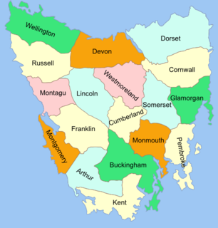
The Lands administrative divisions of Tasmania are the divisions of Tasmania into land districts and parishes for cadastral purposes, which are part of the lands administrative divisions of Australia. There are 20 land districts in Tasmania, although in the early nineteenth century there were several other systems, with 18 or 36 counties and 9 other divisions used, as well as hundreds. The land districts include the 18 former counties of the island of Tasmania which were renamed but retain the same boundaries, plus King Island and Flinders Island. The counties are referenced in the 1911 Encyclopædia Britannica, with Hobart described as being in Buckingham County, Launceston in Cornwall County and Beaconsfield in Devon County. The land districts are used for land titles today, while the Local Government Areas of Tasmania with cities and municipalities are used for political and administrative purposes.

The county of Nares is a cadastral division of Queensland which contains the city of Cairns, Innisfail and most of the Atherton Tableland. It was named after George Nares (1831–1915), a naval officer and commander of HMS Salamander. Cairns is mentioned as being in the county of Nares in the 1911 Britannica. It is bounded by the Daintree River in the north.

Tingoora is a rural town and a locality in the South Burnett Region, Queensland, Australia. In the 2016 census, Tingoora had a population of 273 people.
The County of Cavendish is a county in Queensland, Australia. Like all counties in Queensland, it is a non-functional administrative unit, that is used mainly for the purpose of registering land titles. The county includes the northern part of the Toowoomba Region and the western part of the Somerset Region. The county was officially named and bounded by the Governor in Council on 7 March 1901 under the Land Act 1897.

The County of March is a county in Queensland, Australia. The county consists of the Noosa area, plus the eastern parts of the Gympie and Fraser Coast regions.

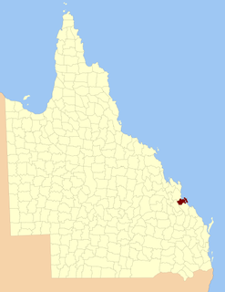
The County of Fraser is one of 322 counties of Queensland, Australia, in the Wide Bay–Burnett region, which consists Fraser Island and some satellite islands off its southwestern coast. It was established on 7 March 1901 under the Land Act 1897, and borders County of March, which lies mainly on the Queensland mainland, but also includes Big Woody Island and other islands in the northern Great Sandy Strait.

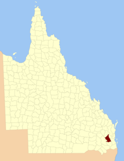
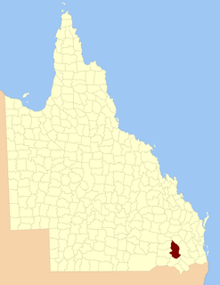
The County of Merivale is a county located on the southern boundary of the state of Queensland, Australia. Like all counties in Queensland, it is a non-functional administrative unit, that is used mainly for the purpose of registering land titles. The county was named in honour of Herman Merivale, the British permanent Under-Secretary of State for the Colonies. Its boundaries were declared and made subject to the Land Act 1897 on 7 March 1901. Population centres within the County of Merivale include the towns of Warwick, Allora and Killarney.
The County of Fitzroy is a county in Queensland, Australia. Like all counties in Queensland, it is a non-functional administrative unit, that is used mainly for the purpose of registering land titles.
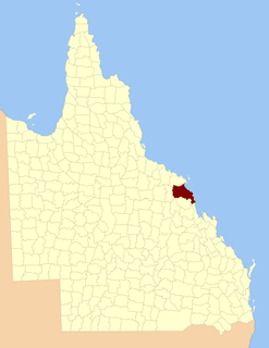
The County of Carlisle is a county in Queensland, Australia. The county is centred on the city of Mackay and includes most of the Mackay Region. It takes its name from Carlisle in England.

The County of Livingstone is a county in Queensland, Australia. It is centred on the city of Rockhampton and includes most of the Rockhampton Region. The county was created on 1 September 1855 by royal proclamation under the Waste Lands Australia Act 1846. On 7 March 1901, the Governor issued a proclamation legally dividing Queensland into counties under the Land Act 1897. Its schedule described Livingstone thus:
Bounded on the south by the county of Deas Thompson and the southern boundaries of the parishes of Plews, Bouldercombe, Mooninera and Playfair; on the west by the western boundaries of the parishes of Playfair, Stanwell, Neerkol, Limestone, Morinish, Yaamba, Canoona and Werribee; on the north by the northern boundaries of the parishes of Werribee, Rosslynn and Yeppoon, and on the east by the Pacific Ocean,—inclusive of Great Keppel, North Keppel, and other adjacent islands.
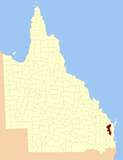
The County of Deas Thompson is a county in Queensland, Australia. It is situated between the cities of Gladstone and Rockhampton. The county was named for Edward Deas Thomson, a New South Wales politician, but the name was misspelt Thompson when applied to the county.
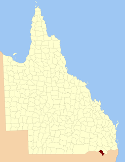
The County of Clive is a county in the southern Darling Downs region of Queensland, Australia, on the state border with New South Wales. It was named and bounded by the Governor in Council on 7 March 1901 under the Land Act 1897.
The County of Derby is a county in the Darling Downs region of Queensland, Australia. It was named and bounded by the Governor in Council on 7 March 1901 under the Land Act 1897.

The County of Cardwell is a county in Far North Queensland, Queensland, Australia, between Cairns and Townsville. It was named and bounded by the Governor in Council on 7 March 1901 under the Land Act 1897. Its name likely honours Edward Cardwell, who was Secretary of State for the Colonies in 1864–1866 and later served as a reformist Secretary of State for War.

The County of Lytton is a county in the Darling Downs region of Queensland, Australia. It was named and bounded by the Governor in Council on 7 March 1901 under the Land Act 1897.

Avondale is a town and a locality in the Bundaberg Region, Queensland, Australia.
The Falls is a rural locality in the Southern Downs Region, Queensland, Australia.
