Oakhurst, Queensland

Last updated

Oakhurst
Queensland
Oakhurst QLD 4650, Australia - panoramio (4).jpg
Locomotive on the North Coast railway line just south of Maryborough West railway station
Australia Queensland location map.svg
Red pog.svg
Oakhurst
Coordinates 25°30′45″S152°37′35″E / 25.5125°S 152.6263°E / -25.5125; 152.6263 (Oakhurst (centre of locality))
Population1,717 (2021 census) [1]
 • Density70.37/km2 (182.3/sq mi)
Postcode(s) 4650
Area24.4 km2 (9.4 sq mi)
Time zone AEST (UTC+10:00)
Location
LGA(s) Fraser Coast Region
State electorate(s) Maryborough
Federal division(s) Wide Bay
Suburbs around Oakhurst:
Dunmora Dunmora Aldershot
Dunmora Oakhurst Maryborough West
Yengarie Yengarie Tinana

Oakhurst is a mixed-use locality in the Fraser Coast Region, Queensland, Australia. [2] In the 2021 census, Oakhurst had a population of 1,717 people. [1]

Contents

Geography

Maryborough West railway station, 2012 Maryborough West Railway Station, Queensland, July 2012.JPG
Maryborough West railway station, 2012

The Mary River forms part of the eastern boundary. [3]

The Maryborough–Biggenden Road (State Route 86) enters the locality from the east (Maryborough West) where it is known as Gayndah Road. It exits the locality to the west (Dunmora/Yengarie). [4]

The North Coast railway line enters the locality from the south (Yengarie). [4] Despite the name, the locality is served by the Maryborough West railway station ( 25°30′29″S152°38′12″E / 25.5080°S 152.6366°E / -25.5080; 152.6366 (Maryborough West railway station) ), which has replaced Maryborough railway station as the main stop serving Maryborough on the North Coast line. [5] The station is the junction where the North Coast railway line splits into two. The new electrified main line exits the locality to the north-east (Aldershot / Maryborough West) bound ultimately for Cairns. The older not-electrified line exits the locality to the east (Maryborough West) bound for Maryborough. This line is still required to transport rolling stock to and from the Walkers Limited workshop (now operated by Downer Rail). [4] [6]

The locality is increasingly becoming a suburb of Maryborough with rural residential housing being the major land use. The remaining land is used for grazing on native vegetation and growing sugarcane. [4]

History

Oakhurst was historically served by the Oakhurst railway station ( 25°30′53″S152°37′58″E / 25.51469°S 152.63264°E / -25.51469; 152.63264 (Oakhurst railway station (former)) ). [7] However, Maryborough West railway station was opened in 1989 as a replacement for Maryborough and Baddow stations, when the latter was bypassed by a new seven kilometre alignment that was built as part of the electrification of the North Coast line. [8] [9]

Once, the locality of Oakhurst was split between the Shire of Woocoo and the City of Maryborough. However, on 2 July 2010, it was regazetted as being solely within the Fraser Coast Region. [2]

Demographics

In the 2016 census, Oakhurst had a population of 1,444 people. [10]

In the 2021 census, Oakhurst had a population of 1,717 people. [1]

Education

There are no schools in Oakhurst. The nearest government primary school is Sunbury State School in Maryborough to the east. The nearest government secondary school is Aldridge State High School, also in Maryborough. [11]

TAFE Queensland delivers vocational education at its Wide Bay campus at 65 Nagel Street ( 25°30′21″S152°39′16″E / 25.5058°S 152.6545°E / -25.5058; 152.6545 (Wide Bay TAFE campus) ). [12]

Amenities

Wook-koo Park (formerly Oakhurst Park) is on the south-eastern corner of Loretta Drive and Woocoo Drive ( 25°30′57″S152°36′53″E / 25.5158°S 152.6146°E / -25.5158; 152.6146 (Oakhurst Park) ). It offers facilities for sport, picnics and BBQs, and walking tracks. One walk features sculptures of animals. [13] [14] [15]

Facilities

Oakhurst SES Facility is at 5 Boundary Road ( 25°30′54″S152°37′30″E / 25.5150°S 152.6249°E / -25.5150; 152.6249 (Oakhurst SES Facility) ). [16]

Related Research Articles

<span class="mw-page-title-main">Tiaro, Queensland</span> Town in Queensland, Australia

Tiaro is a rural town and locality in the Fraser Coast Region, Queensland, Australia. In the 2021 census, the locality of Tiaro had a population of 778 people.

<span class="mw-page-title-main">Howard, Queensland</span> Town in Queensland, Australia

Howard is a rural town and locality in the Fraser Coast Region, Queensland, Australia. It is a southern boundary of the Dundaburra peoples of the Northern Kabi Kabi Isis districts and surrounds. It is located 284 kilometres (176 mi) north of Brisbane and 37 kilometres (23 mi) west of Hervey Bay. In the 2021 census, the locality of Howard had a population of 1,394 people.

<span class="mw-page-title-main">Fraser Coast Region</span> Local government area in Queensland, Australia

The Fraser Coast Region is a local government area in the Wide Bay–Burnett region of Queensland, Australia, about 250 kilometres (160 mi) north of Brisbane, the state capital. It is centred on the twin cities of Hervey Bay and Maryborough and also contains K'gari. It was created in 2008 from a merger of the Cities of Maryborough and Hervey Bay and the Shires of Woocoo and most of Tiaro. The resident population at the 2021 census was 111,032 and the estimated population in 2023 was 117,940.

<span class="mw-page-title-main">Brooweena, Queensland</span> Town in Queensland, Australia

Brooweena is a rural town and locality in the Fraser Coast Region, Queensland, Australia. In the 2021 census, the locality of Brooweena had a population of 91 people.

<span class="mw-page-title-main">Theebine</span> Town in Queensland, Australia

Theebine is a rural town and locality split between the Gympie Region and the Fraser Coast Region, both in Queensland, Australia.

<span class="mw-page-title-main">Gunalda</span> Town in Queensland, Australia

Gunalda is a rural town in the Gympie Region and a locality split between Gympie Region and Fraser Coast Region in Queensland, Australia. In the 2021 census, the locality of Gunalda had a population of 426 people.

<span class="mw-page-title-main">Gundiah</span> Town in Queensland, Australia

Gundiah is a rural town and locality in the Fraser Coast Region, Queensland, Australia. In the 2021 census, the locality of Gundiah had a population of 89 people.

<span class="mw-page-title-main">Tinana, Queensland</span> Town in Queensland, Australia

Tinana is a rural town and locality in the Fraser Coast Region, Queensland, Australia. In the 2021 census, the locality of Tinana had a population of 5,872 people.

<span class="mw-page-title-main">Torbanlea</span> Town in Queensland, Australia

Torbanlea is a rural town and locality in the Fraser Coast Region, Queensland, Australia. In the 2021 census, the locality of Torbanlea had a population of 841 people.

<span class="mw-page-title-main">Antigua, Queensland</span> Suburb of Fraser Coast Region, Queensland, Australia

Antigua is a rural locality in the Fraser Coast Region, Queensland, Australia. In the 2021 census, Antigua had a population of 126 people.

<span class="mw-page-title-main">Mungar</span> Suburb of Fraser Coast Region, Queensland, Australia

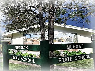
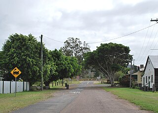
Mungar is a rural locality in the Fraser Coast Region, Queensland, Australia. In the 2021 census, Mungar had a population of 328 people.

<span class="mw-page-title-main">Bauple, Queensland</span> Town in Queensland, Australia

Bauple is a rural town and locality in the Fraser Coast Region, Queensland, Australia. In the 2021 census, the locality of Bauple had a population of 745 people.

Owanyilla is a rural town and locality in the Fraser Coast Region, Queensland, Australia. In the 2021 census, the locality of Owanyilla had a population of 245 people.

North Aramara is a rural locality in the Fraser Coast Region, Queensland, Australia. In the 2021 census, North Aramara had a population of 45 people.

Boompa is a rural locality in the Fraser Coast Region, Queensland, Australia. In the 2021 census, Boompa had a population of 89 people.

<span class="mw-page-title-main">Gootchie, Queensland</span> Suburb of Fraser Coast Region, Queensland, Australia

Gootchie is a rural locality in the Fraser Coast Region, Queensland, Australia. In the 2021 census, Gootchie had a population of 96 people.

<span class="mw-page-title-main">Teebar, Queensland</span> Suburb of Fraser Coast Region, Queensland, Australia

Teebar is a rural locality in the Fraser Coast Region, Queensland, Australia. In the 2021 census, Teebar had a population of 59 people.

Netherby is a rural locality in the Fraser Coast Region, Queensland, Australia. In the 2021 census, Netherby had a population of 25 people.

<span class="mw-page-title-main">Grahams Creek, Queensland</span> Suburb of Fraser Coast Region, Queensland, Australia

Grahams Creek is a rural locality in the Fraser Coast Region, Queensland, Australia. In the 2021 census, Grahams Creek had a population of 149 people.

Paterson is a rural locality in the Fraser Coast Region, Queensland, Australia. In the 2021 census, Paterson had a population of 157 people.

References

  1. 1 2 3 Australian Bureau of Statistics (28 June 2022). "Oakhurst (SAL)". 2021 Census QuickStats. Retrieved 28 February 2023. OOjs UI icon edit-ltr-progressive.svg
  2. 1 2 "Oakhurst – locality in Fraser Coast Region (entry 46731)". Queensland Place Names. Queensland Government . Retrieved 10 December 2018.
  3. Google (20 August 2021). "Oakhurst, Queensland" (Map). Google Maps . Google. Retrieved 20 August 2021.
  4. 1 2 3 4 "Queensland Globe". State of Queensland . Retrieved 23 December 2023.
  5. "Railway stations and sidings - Queensland". Queensland Open Data. Queensland Government. 2 October 2020. Archived from the original on 5 October 2020. Retrieved 5 October 2020.
  6. "Accessibility upgrade works at Maryborough". Queensland Department of Transport and Main Roads. Archived from the original on 22 March 2023. Retrieved 24 December 2023.
  7. "Maryborough" (Map). Queensland Government. 1942. Archived from the original on 14 September 2023. Retrieved 24 December 2023.
  8. "Parliamentary Debates [Hansard]" (PDF). Queensland Legislative Assembly. 27 February 1986. p. 3920. Archived (PDF) from the original on 22 December 2014. Retrieved 24 December 2023.
  9. "The Maryborough Shunt" Railway Digest November 2013 pages 40-43
  10. Australian Bureau of Statistics (27 June 2017). "Oakhurst (SSC)". 2016 Census QuickStats. Retrieved 20 October 2018. OOjs UI icon edit-ltr-progressive.svg
  11. "Layers: Locality; Schools and school catchments". Queensland Globe. Queensland Government. Archived from the original on 19 December 2017. Retrieved 23 December 2023.
  12. "Landmark Areas - Queensland". Queensland Open Data. Queensland Government. 18 November 2020. Archived from the original on 21 November 2020. Retrieved 21 October 2020.
  13. "Wook-Koo Park". Fraser Coast Regional Council. Archived from the original on 6 June 2023. Retrieved 23 December 2023.
  14. "Land for public recreation - Queensland". Queensland Open Data. Queensland Government. 20 November 2020. Archived from the original on 22 November 2020. Retrieved 22 November 2020.
  15. "Wook-Koo Park and Story Walk". Fraser Coast Regional Council. Archived from the original on 22 March 2023. Retrieved 24 December 2023.
  16. "Emergency services facilities - Queensland". Queensland Open Data. Queensland Government. 18 November 2020. Archived from the original on 24 November 2020. Retrieved 24 November 2020.