Mungar

Last updated

Mungar
Queensland
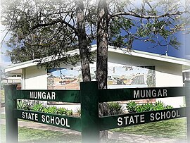
Mungar State School, 2023.jpg
Mungar State School, 2023
Australia Queensland location map.svg
Red pog.svg
Mungar
Coordinates 25°36′10″S152°35′40″E / 25.6027°S 152.5944°E / -25.6027; 152.5944
Population309 (2016 census) [1]
 • Density20.33/km2 (52.65/sq mi)
Postcode(s) 4650
Area15.2 km2 (5.9 sq mi)
Time zone AEST (UTC+10:00)
Location
LGA(s) Fraser Coast Region
State electorate(s) Maryborough
Federal division(s) Wide Bay
Suburbs around Mungar:
Yerra Grahams Creek Tinana South
Pilerwa Mungar Ferney
Antigua Antigua Ferney

Mungar is a rural locality in the Fraser Coast Region, Queensland, Australia. [2] In the 2016 census, Mungar had a population of 309 people. [1]

Contents

Geography

Mungar is 247 kilometres (153 mi) north of the state capital Brisbane and 20 kilometres (12 mi) south west of the regional centre of Maryborough.

The Mungar Junction to Monto Branch Railway branches from the North Coast railway line at Mungar.

History

Mary River Saw Mill Provisional School opened on 9 July 1875. On 24 Sep 1877, it was renamed Mungar State School. [3]

At the 2011 census, Mungar and the surrounding area had a population of 264. [4]

Education

Mungar State School library, 2023 Mungar State School library, 2023.jpg
Mungar State School library, 2023

Mungar State School is a government primary (Prep-6) school for boys and girls at 1143 Mungar Road ( 25°36′15″S152°35′26″E / 25.6041°S 152.5906°E / -25.6041; 152.5906 (Mungar State School) ). [5] [6] In 2017, the school had an enrolment of 44 students with 3 teachers (2 full-time equivalent) and 4 non-teaching staff (3 full-time equivalent). [7]

There are no secondary schools in Mungar. The nearest government secondary school is Aldridge State High School in Maryborough to the north-east. [8]

See also

Related Research Articles

<span class="mw-page-title-main">Tiaro, Queensland</span> Town in Queensland, Australia

Tiaro is a rural town and locality in the Fraser Coast Region, Queensland, Australia. In the 2021 census, the locality of Tiaro had a population of 778 people.

<span class="mw-page-title-main">Howard, Queensland</span> Town in Queensland, Australia

Howard is a rural town and locality in the Fraser Coast Region, Queensland, Australia. It is a southern boundary of the Dundaburra peoples of the Northern Kabi Kabi Isis districts and surrounds. In the 2016 census, Howard had a population of 1,359 people. It is located 284 kilometres (176 mi) north of Brisbane and 37 kilometres (23 mi) west of Hervey Bay.

Araluen is a residential locality in Gympie in the Gympie Region, Queensland, Australia. In the 2016 census, Araluen had a population of 614 people.

<span class="mw-page-title-main">Brooweena, Queensland</span> Town in Queensland, Australia

Brooweena is a rural town and locality in the Fraser Coast Region, Queensland, Australia. In the 2016 census, Brooweena had a population of 104 people.

<span class="mw-page-title-main">Theebine</span> Town in Queensland, Australia

Theebine is a rural town and locality split between the Gympie Region and the Fraser Coast Region, both in Queensland, Australia.

<span class="mw-page-title-main">Gunalda</span> Town in Queensland, Australia

Gunalda is a rural town in the Gympie Region and a locality split between Gympie Region and Fraser Coast Region in Queensland, Australia. In the 2016 census, the locality of Gunalda had a population of 392 people.
<span class="mw-page-title-main">Gundiah</span> Town in Queensland, Australia

Gundiah is a rural town and locality in the Fraser Coast Region, Queensland, Australia. In the 2016 census, the locality of Gundiah had a population of 123 people.

Glenwood is a locality split between the Fraser Coast Region and the Gympie Region in Queensland, Australia. In the 2016 census, Glenwood had a population of 1,535 people.
<span class="mw-page-title-main">Torbanlea</span> Town in Queensland, Australia

Torbanlea is a rural town and locality in the Fraser Coast Region, Queensland, Australia. In the 2016 census the locality of Torbanlea had a population of 791 people.

<span class="mw-page-title-main">Antigua, Queensland</span> Suburb of Fraser Coast Region, Queensland, Australia

Antigua is a rural locality in the Fraser Coast Region, Queensland, Australia. In the 2016 census, Antigua had a population of 127 people.

<span class="mw-page-title-main">Bauple, Queensland</span> Town in Queensland, Australia

Bauple is a rural town and locality in the Fraser Coast Region, Queensland, Australia. In the 2016 census the locality of Bauple had a population of 644 people.

Aramara is a rural town and locality in the Fraser Coast Region, Queensland, Australia. In the 2016 census, the locality of Aramara had a population of 57 people.

Kanigan is a rural locality split between the Fraser Coast Region and the Gympie Region, both in Queensland, Australia. In the 2016 census Kanigan had a population of 114 people.

Pioneers Rest is a rural locality in the Fraser Coast Region, Queensland, Australia. In the 2016 census Pioneers Rest had a population of 60 people.

Poona is a coastal town and locality in the Fraser Coast Region, Queensland, Australia. In the 2016 census the locality of Poona had a population of 481 people.
<span class="mw-page-title-main">Gootchie, Queensland</span> Suburb of Fraser Coast Region, Queensland, Australia

Gootchie is a rural locality in the Fraser Coast Region, Queensland, Australia. In the 2021 census, Gootchie had a population of 96 people.

Point Vernon is a coastal suburb in the Fraser Coast Region, Queensland, Australia. In the 2021 census, Point Vernon had a population of 5,718 people.

Tuan is a coastal rural town and locality in the Fraser Coast Region, Queensland, Australia. In the 2021 census, the locality of Tuan had a population of 140 people.

Doongul is a rural locality in the Fraser Coast Region, Queensland, Australia. In the 2021 census, Doongul had a population of 35 people.
<span class="mw-page-title-main">Grahams Creek, Queensland</span> Suburb of Fraser Coast Region, Queensland, Australia

Grahams Creek is a rural locality in the Fraser Coast Region, Queensland, Australia. In the 2021 census, Grahams Creek had a population of 149 people.
References

  1. 1 2 Australian Bureau of Statistics (27 June 2017). "Mungar (SSC)". 2016 Census QuickStats. Retrieved 20 October 2018. OOjs UI icon edit-ltr-progressive.svg
  2. "Mungar – locality in Fraser Coast Region (entry 46730)". Queensland Place Names. Queensland Government . Retrieved 16 November 2019.
  3. Queensland Family History Society (2010), Queensland schools past and present (Version 1.01 ed.), Queensland Family History Society, ISBN   978-1-921171-26-0
  4. Australian Bureau of Statistics (31 October 2012). "Mungar (State Suburb)". 2011 Census QuickStats. Retrieved 13 June 2015. OOjs UI icon edit-ltr-progressive.svg
  5. "State and non-state school details". Queensland Government. 9 July 2018. Archived from the original on 21 November 2018. Retrieved 21 November 2018.
  6. "Mungar State School". Mungar State School. 28 July 2022. Archived from the original on 1 March 2023. Retrieved 13 September 2023.
  7. "ACARA School Profile 2017". Archived from the original on 22 November 2018. Retrieved 22 November 2018.
  8. "Layers: Locality; Schools and school catchments". Queensland Globe. Queensland Government. Archived from the original on 19 December 2017. Retrieved 13 September 2023.