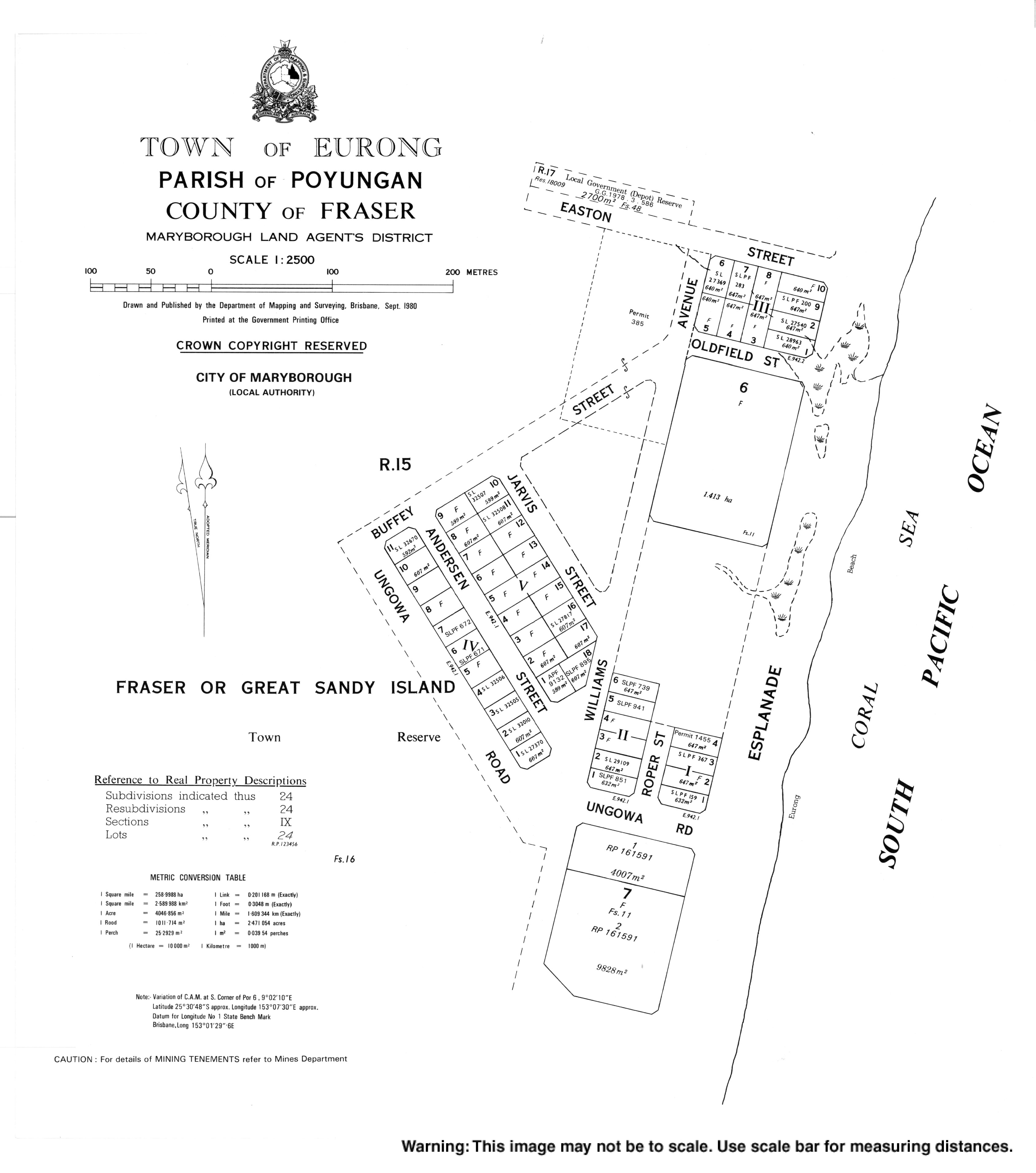
Eurong Queensland | |||||||||||||||
---|---|---|---|---|---|---|---|---|---|---|---|---|---|---|---|
Coordinates | 25°30′41″S153°07′34″E / 25.5113°S 153.1261°E Coordinates: 25°30′41″S153°07′34″E / 25.5113°S 153.1261°E | ||||||||||||||
Population | 47 (2016 census) [1] | ||||||||||||||
• Density | 16.2/km2 (42.0/sq mi) | ||||||||||||||
Postcode(s) | 4581 | ||||||||||||||
Area | 2.9 km2 (1.1 sq mi) | ||||||||||||||
Time zone | AEST (UTC+10:00) | ||||||||||||||
LGA(s) | Fraser Coast Region | ||||||||||||||
State electorate(s) | Hervey Bay | ||||||||||||||
Federal division(s) | Wide Bay | ||||||||||||||
|
Eurong is a town and a locality on Fraser Island (also known as K'Gari and Gari) in the Fraser Coast Region, Queensland, Australia. [2] [3] In the 2016 census, Eurong had a population of 47 people. [1]
Fraser Island is divided into two localities, one very small one, Eurong, and very large one called Fraser Island (the locality) with Happy Valley its only town. Eurong is on the east coast of Fraser Island facing the Coral Sea about one quarter of the length of the island from its southern trip. Consequently, on the land, Eurong is completely surrounded by the locality of Fraser Island. [4]
The name Eurong is believed to be a Kabi language word meaning rain forest . [2]
Timber getting was the first industry in the area. By 1927, there was a settlement of forestry workers and their families (approximately 50 people) in the Eurong area. It was a very isolated settlement with a fortnightly steamer service to go to Maryborough for the weekend for shopping; apart from there was no communication or transport from Eurong. The housing was primitive, often not weatherproof in the rain. However, there was an excellent water supply from the creek. [5]
By 1937, the settlement had developed and included a dance hall. Groups of people started to come from Maryborough and Pialba to Eurong for sightseeing, swimming, picnicking, and dancing, the beginning of the tourist industry that exists today. [6]
Fraser Island is a World Heritage-listed island along the south-eastern coast in the Wide Bay–Burnett region, Queensland, Australia. The island is approximately 250 kilometres (160 mi) north of the state capital, Brisbane, and is within the Fraser Coast Region local government area. The world heritage listing includes the island, its surrounding waters and parts of the nearby mainland.
Maryborough is a city and a suburb in the Fraser Coast Region, Queensland, Australia. As of June 2018 Maryborough had an estimated urban population of 27,282, having grown slightly at an annual average of 0.12% year-on-year over the preceding five years.
Hervey Bay is a city on the coast of the Fraser Coast Region of Queensland, Australia. The city is situated approximately 290 kilometres (180 mi) or 3½ hours' highway drive north of the state capital, Brisbane. It is located on the bay of the same name open to the Coral Sea between the Queensland mainland and nearby Fraser Island. The local economy relies on tourism which is based primarily around whale watching in Platypus Bay to the north, ferry access to Fraser Island, accessible recreational fishing and boating and the natural north facing, calm beaches with wide undeveloped foreshore zones. In October 2019, Hervey Bay was named the First Whale Heritage Site in the world by the World Cetacean Alliance, for its commitment to and practices of sustainable whale and dolphin watching. A 2010 study by Deakin University showed that people on the Fraser Coast area including Hervey Bay, were the happiest in Australia. At June 2018, there were an estimated 54,674 people in Hervey Bay, having grown by an annual average of 1.31% year-on-year over the preceding five years.
Tiaro is a rural town and locality in the Fraser Coast Region, Queensland, Australia. In the 2016 census, the locality of Tiaro had a population of 758 people.
The Shire of Woocoo was a local government area located in the Wide Bay–Burnett region of Queensland, Australia, containing the rural residential area to the west of the town of Maryborough, and surrounding countryside. The shire covered an area of 2,007.9 square kilometres (775.3 sq mi), and existed as a local government entity from 1914 until 2008, when it was amalgamated with the City of Maryborough, City of Hervey Bay and the 1st and 2nd divisions of the Shire of Tiaro to form the Fraser Coast Region.
The City of Maryborough was a local government area located in the Wide Bay–Burnett region of Queensland, Australia, containing the urban locality of Maryborough as well as the southern half of Fraser Island. The City covered an area of 1,233.9 square kilometres (476.4 sq mi), and existed as a local government entity from 1861 until 2008, when it was amalgamated with the City of Hervey Bay, Shire of Woocoo and the 1st and 2nd divisions of the Shire of Tiaro to form the Fraser Coast Region.
Glenwood is a locality split between the Fraser Coast Region and the Gympie Region in Queensland, Australia. In the 2016 census, Glenwood had a population of 1,535 people.
Aldershot is a rural town and locality in the Fraser Coast Region, Queensland, Australia. In the 2016 census, Aldershot had a population of 1,152 people.
Toolara Forest is a locality split between Gympie Region and Fraser Coast Region, Queensland, Australia. In the 2016 census Toolara Forest had a population of 0 people.
Owanyilla is a rural town and locality in the Fraser Coast Region, Queensland, Australia. In the 2016 census the locality of Owanyilla had a population of 194 people.
Happy Valley is a coastal town in the locality of Fraser Island in the Fraser Coast Region, Queensland, Australia.
Aramara is a rural town and locality in the Fraser Coast Region, Queensland, Australia. In the 2016 census, the locality of Aramara had a population of 57 people.
Poona is a coastal town and locality in the Fraser Coast Region, Queensland, Australia. In the 2016 census the locality of Poona had a population of 481 people.
Tinnanbar is a coastal town and a locality in the Fraser Coast Region, Queensland, Australia. In the 2016 census, Tinnanbar had a population of 123 people.
Oakhurst is a locality in the Fraser Coast Region, Queensland, Australia. In the 2016 census, Oakhurst had a population of 1,444 people.
Tuan is a coastal rural town and locality in the Fraser Coast Region, Queensland, Australia. In the 2016 census, Tuan had a population of 153 people.
Susan River is a rural locality in the Fraser Coast Region, Queensland, Australia. In the 2016 census, Susan River had a population of 136 people.
Island Plantation is a rural locality in the Fraser Coast Region, Queensland, Australia. In the 2016 census, Island Plantation had a population of 146 people.
Doongul is a rural locality in the Fraser Coast Region, Queensland, Australia. In the 2016 census, Doongul had a population of 29 people.
Grahams Creek is a rural locality in the Fraser Coast Region, Queensland, Australia. In the 2016 census, Grahams Creek had a population of 157 people.