Bidwill, Queensland

Last updated

Bidwill
Queensland
Australia Queensland location map.svg
Red pog.svg
Bidwill
Coordinates 25°35′09″S152°43′10″E / 25.5858°S 152.7194°E / -25.5858; 152.7194
Population517 (2021 census) [1]
 • Density15.43/km2 (39.97/sq mi)
Postcode(s) 4650
Area33.5 km2 (12.9 sq mi)
Time zone AEST (UTC+10:00)
Location
LGA(s) Fraser Coast Region
State electorate(s) Maryborough
Federal division(s) Wide Bay
Suburbs around Bidwill:
Tinana Maryborough
Granville
Boonooroo Plains
Tinana South Bidwill Tuan Forest
Teddington Magnolia Tuan Forest

Bidwill is a locality in the Fraser Coast Region, Queensland, Australia. [2] In the 2021 census, Bidwill had a population of 517 people. [1]

Contents

Geography

The Mary River forms the short north-western boundary, while Jumpo Creek forms the western boundary on its way to join the Mary. [3]

History

The locality takes its name from the parish and creek, which in turn were named after botanist John Carne Bidwill, who was Commissioner for Crown Lands in the Wide Bay area in 1848 to 1853 and lived in the area. [4] [5]

Bidwell Provisional School opened in 1896. On 1 January 1909, it became Bidwell State School. It closed in 1936. [6] Note the spelling of district name was later changed to be Bidwill. The school was at 741 Bidwill Road ( 25°37′00″S152°42′45″E / 25.61676°S 152.71243°E / -25.61676; 152.71243 (Bidwell State School (former)) ). [7]

Demographics

In the 2016 census, Bidwill had a population of 491 people. [8]

In the 2021 census, Bidwill had a population of 517 people. [1]

Education

There are no schools in Bidwill. The nearest government primary schools are Granville State School in neighbouring Granville to the north and Parke State School in neighbouring Tinana South to the west. The nearest government secondary school is Maryborough State High School in neighbouring Maryborough to the north. [9]

Related Research Articles

<span class="mw-page-title-main">River Heads, Queensland</span> Town in Queensland, Australia

River Heads is a coastal town and locality in the Fraser Coast Region, Queensland, Australia. In the 2021 census, the locality of River Heads had a population of 2,044 people.

<span class="mw-page-title-main">Tinana, Queensland</span> Town in Queensland, Australia

Tinana is a rural town and locality in the Fraser Coast Region, Queensland, Australia. In the 2021 census, the locality of Tinana had a population of 5,872 people.

<span class="mw-page-title-main">Antigua, Queensland</span> Suburb of Fraser Coast Region, Queensland, Australia

Antigua is a rural locality in the Fraser Coast Region, Queensland, Australia. In the 2021 census, Antigua had a population of 126 people.

<span class="mw-page-title-main">Mungar</span> Suburb of Fraser Coast Region, Queensland, Australia

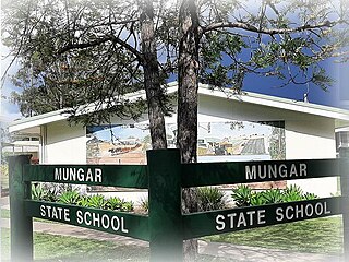
Mungar is a rural locality in the Fraser Coast Region, Queensland, Australia. In the 2021 census, Mungar had a population of 328 people.

Granville is a rural locality in the Fraser Coast Region, Queensland, Australia. It is a suburb of Maryborough. In the 2021 census, Granville had a population of 2,532 people.

North Aramara is a rural locality in the Fraser Coast Region, Queensland, Australia. In the 2021 census, North Aramara had a population of 45 people.

Boonooroo is a coastal town and locality in the Fraser Coast Region, Queensland, Australia. In the 2021 census, the locality of Boonooroo had a population of 371 people.

Poona is a coastal town and locality in the Fraser Coast Region, Queensland, Australia. In the 2021 census, the locality of Poona had a population of 576 people.

<span class="mw-page-title-main">Oakhurst, Queensland</span> Suburb of Fraser Coast Region, Queensland, Australia

Oakhurst is a mixed-use locality in the Fraser Coast Region, Queensland, Australia. In the 2021 census, Oakhurst had a population of 1,717 people.

<span class="mw-page-title-main">Gootchie, Queensland</span> Suburb of Fraser Coast Region, Queensland, Australia

Gootchie is a rural locality in the Fraser Coast Region, Queensland, Australia. In the 2021 census, Gootchie had a population of 96 people.

Tuan is a coastal rural town and locality in the Fraser Coast Region, Queensland, Australia. In the 2021 census, the locality of Tuan had a population of 140 people.

Teddington is a rural locality in the Fraser Coast Region, Queensland, Australia. In the 2021 census, Teddington had a population of 236 people.

Beaver Rock is a rural locality in the Fraser Coast Region, Queensland, Australia. In the 2021 census, Beaver Rock had a population of 56 people.

Dundathu is a rural locality in the Fraser Coast Region, Queensland, Australia. In the 2021 census, Dundathu had a population of 238 people.

The Dimonds is a rural locality in the Fraser Coast Region, Queensland, Australia. In the 2021 census, The Dimonds had "no people or a very low population".

Mount Urah is a rural locality in the Fraser Coast Region, Queensland, Australia. In the 2021 census, Mount Urah had a population of 49 people.

Netherby is a rural locality in the Fraser Coast Region, Queensland, Australia. In the 2021 census, Netherby had a population of 25 people.

Doongul is a rural locality in the Fraser Coast Region, Queensland, Australia. In the 2021 census, Doongul had a population of 35 people.

Gungaloon is a locality in the Fraser Coast Region, Queensland, Australia. In the 2021 census, Gungaloon had a population of 27 people.

<span class="mw-page-title-main">Grahams Creek, Queensland</span> Suburb of Fraser Coast Region, Queensland, Australia

Grahams Creek is a rural locality in the Fraser Coast Region, Queensland, Australia. In the 2021 census, Grahams Creek had a population of 149 people.

References

  1. 1 2 3 Australian Bureau of Statistics (28 June 2022). "Bidwill (SAL)". 2021 Census QuickStats. Retrieved 28 February 2023. OOjs UI icon edit-ltr-progressive.svg
  2. "Bidwill – locality in Fraser Coast Region (entry 46629)". Queensland Place Names. Queensland Government . Retrieved 10 June 2019.
  3. Google (20 August 2021). "Bidwill, Queensland" (Map). Google Maps . Google. Retrieved 20 August 2021.
  4. "Bidwill Creek – watercourse in the Fraser Coast Region (entry 2460)". Queensland Place Names. Queensland Government . Retrieved 25 June 2024.
  5. "Bidwill – parish in the Fraser Coast Region (entry 2459)". Queensland Place Names. Queensland Government . Retrieved 26 June 2024.
  6. Queensland Family History Society (2010), Queensland schools past and present (Version 1.01 ed.), Queensland Family History Society, ISBN   978-1-921171-26-0
  7. "County of March" (Map). Queensland Government. 1922. Retrieved 26 June 2024.
  8. Australian Bureau of Statistics (27 June 2017). "Bidwill (SSC)". 2016 Census QuickStats. Retrieved 20 October 2018. OOjs UI icon edit-ltr-progressive.svg
  9. "Layers: Locality; Schools and school catchments". Queensland Globe. Queensland Government. Archived from the original on 19 December 2017. Retrieved 26 June 2024.