Torquay, Queensland

Last updated

Torquay
Hervey Bay,  Queensland
Hbay.JPG
Beach at Torquay in 2006
Australia Queensland location map.svg
Red pog.svg
Torquay
Torquay, Queensland
Coordinates 25°17′29″S152°52′24″E / 25.2913°S 152.8733°E / -25.2913; 152.8733 (Torquay (centre of suburb))
Population6,316 (2016 census) [1]
 • Density1,344/km2 (3,480/sq mi)
Postcode(s) 4655
Elevation4 m (13 ft)
Area4.7 km2 (1.8 sq mi)
Time zone AEST (UTC+10:00)
Location
LGA(s) Fraser Coast Region
State electorate(s) Hervey Bay
Federal division(s) Wide Bay
Mean max tempMean min tempAnnual rainfall
30.0 °C
86 °F
16.6 °C
62 °F
1,061.6 mm
41.8 in
Suburbs around Torquay:
Coral Sea Coral Sea Coral Sea
Scarness Torquay Urangan
Kawungan Wondunna Urangan

Torquay ( /tɔːrk/ tor-KEY) is a coastal suburb in Hervey Bay in the Fraser Coast Region, Queensland, Australia. [2] In the 2016 census, Torquay had a population of 6,316 people. [1]

Contents

Geography

Torquay is located 298 kilometres (185 mi) north of Brisbane. Torquay is one of five beachside suburbs in Hervey Bay that is made up of primarily residential homes with some tourist accommodation in apartment buildings.

History

The name Torquay might appear to be a reference to the English seaside town of Torquay, but its origins are believed to be a corruption of Kabi language words dhakki-talbur, reduced to dhakki meaning either a place of short stones, a rocky reef or a stone axe. The similarity of the sound of the word probably gave rise to the English-town spelling. [2]

Torquay Provisional School opened on 21 January 1901. On 1 January 1909 it became Torquay State School. [3]

The Pialba-to-Urangan section of the Hervey Bay railway opened on 19 December 1913 with Torquay railway station ( 25°17′22″S152°52′11″E / 25.2895°S 152.8696°E / -25.2895; 152.8696 (Torquay railway station (former)) ) serving the local area. [4] The line closed on 30 June 1993. [5] [6] The railway station site has been redeveloped as housing. [7]

In 1919, a Baptist church opened in Torquay. [8] [9] It was erected by the Maryborough Baptist Church. [10] [11] Tenders were called in June 1919 with Messrs Payne and Jacobi chosen as the contractors in July 1919. [12] [13] The new church was officially opened on Saturday 4 October 1919 with a special excursion train from Maryborough arranged for those attending the opening. Over 500 people travelled to attend the opening. [14] [15] The church was at approx 270 Torquay Terrace ( 25°17′11″S152°52′02″E / 25.2864°S 152.8671°E / -25.2864; 152.8671 (Torquay Baptist Church (former)) ). [16] [17] The church building has subsequently been relocated to 44 Wheeley Road, Booral, where it is used as a private residence. [18] [19]

All Souls' Anglican Church opened in 1968. It closed circa 1988. [20]

Star of the Sea Catholic School opened on 23 January 1984. [3]

In the 2006 census Torquay had a population of 5,693 people. [21]

In the 2016 census, Torquay had a population of 6,316 people. [1]

Education

Torquay State School is a government primary (Prep-6) school for boys and girls at Tavistock Street ( 25°17′16″S152°51′54″E / 25.2877°S 152.8649°E / -25.2877; 152.8649 (Torquay State School) ). [22] [23] In 2018, the school had an enrolment of 441 students with 36 teachers (31 full-time equivalent) and 25 non-teaching staff (15 full-time equivalent). [24] It includes a special education program. [22] [25]

Star of the Sea Catholic School is a Catholic primary (Prep-6) school for boys and girls at Hughes Road ( 25°18′25″S152°52′26″E / 25.3069°S 152.8739°E / -25.3069; 152.8739 (Star of the Sea Catholic School) ). [22] [26] In 2018, the school had an enrolment of 349 students with 23 teachers (20 full-time equivalent) and 18 non-teaching staff (9 full-time equivalent). [24]

There is no secondary school in Torquay. The nearest secondary school is Urangan State High School just across the border to neighbouring Urangan to the east. [7]

Amenities

Hervey Bay Uniting Church is on the north-east corner of Exeter Street and Tavistock Streets ( 25°17′36″S152°51′55″E / 25.2934°S 152.8653°E / -25.2934; 152.8653 (Hervey Bay Uniting Church) ). [27] [28]

The Kingdom Hall of Jehovah's Witnesses is at 88 Exeter Street ( 25°17′38″S152°52′11″E / 25.2938°S 152.8696°E / -25.2938; 152.8696 (Kingdom Hall of Jehovah's Witnesses, Torquay) ). [29] [30]

Related Research Articles

<span class="mw-page-title-main">Maryborough, Queensland</span> City in Queensland, Australia

Maryborough is a city and a suburb in the Fraser Coast Region, Queensland, Australia. At the 2021 Census, the suburb of Maryborough had a population of 15,287.

<span class="mw-page-title-main">Goomeri</span> Town in Queensland, Australia

Goomeri is a rural town and locality in the Gympie Region, Queensland, Australia. In the 2016 census, the locality of Goomeri had a population of 664 people.

<span class="mw-page-title-main">River Heads, Queensland</span> Town in Queensland, Australia

River Heads is a coastal town and locality in the Fraser Coast Region, Queensland, Australia. In the 2021 census, the locality of River Heads had a population of 2,044 people.

<span class="mw-page-title-main">Howard, Queensland</span> Town in Queensland, Australia

Howard is a rural town and locality in the Fraser Coast Region, Queensland, Australia. It is a southern boundary of the Dundaburra peoples of the Northern Kabi Kabi Isis districts and surrounds. In the 2016 census, Howard had a population of 1,359 people. It is located 284 kilometres (176 mi) north of Brisbane and 37 kilometres (23 mi) west of Hervey Bay.

<span class="mw-page-title-main">Pialba</span> Suburb of Hervey Bay, Queensland, Australia

Pialba is a coastal town and suburb of Hervey Bay in the Fraser Coast Region, Queensland, Australia. It is the central business district of Hervey Bay. In the 2016 census, Pialba had a population of 3,678 people.

<span class="mw-page-title-main">Theebine</span> Town in Queensland, Australia

Theebine is a rural town and locality split between the Gympie Region and the Fraser Coast Region, both in Queensland, Australia.

<span class="mw-page-title-main">Urangan, Queensland</span> Suburb of Hervey Bay, Queensland, Australia

Urangan is a coastal suburb of Hervey Bay in the Fraser Coast Region, Queensland, Australia. In the 2016 census Urangan had a population of 9,764 people.

<span class="mw-page-title-main">Port of Maryborough</span> Port in Australia

The Port of Maryborough, Queensland, was opened in 1847 and in 1859 it was declared a port of entry, meaning that overseas and intercolonial vessels could arrive and depart direct, although there appears to have been considerable uncertainty about the name of the port outside Queensland for some years. Customs officials elsewhere and such publications as the Mercantile Navy List frequently called the port "Wide Bay" well into the 1860s.

<span class="mw-page-title-main">Tinana, Queensland</span> Town in Queensland, Australia

Tinana is a rural town and locality in the Fraser Coast Region, Queensland, Australia. In the 2021 census, the locality of Tinana had a population of 5,872 people.

<span class="mw-page-title-main">Torbanlea</span> Town in Queensland, Australia

Torbanlea is a rural town and locality in the Fraser Coast Region, Queensland, Australia. In the 2016 census the locality of Torbanlea had a population of 791 people.

<span class="mw-page-title-main">Burrum Heads</span> Town in Queensland, Australia

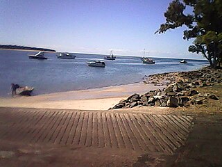
Burrum Heads is a coastal town and locality in the Fraser Coast Region, Queensland, Australia. In the 2016 census, Burrum Heads had a population of 2,067 people.

<span class="mw-page-title-main">Bauple, Queensland</span> Town in Queensland, Australia

Bauple is a rural town and locality in the Fraser Coast Region, Queensland, Australia. In the 2016 census the locality of Bauple had a population of 644 people.

Urraween is a suburb of Hervey Bay in the Fraser Coast Region, Queensland, Australia. At the 2021 census Urraween had a population of 7,951.

Granville is a rural locality in the Fraser Coast Region, Queensland, Australia. It is a suburb of Maryborough. In the 2016 census Granville had a population of 2,716 people.

Nikenbah is a rural town and locality in the Fraser Coast Region, Queensland, Australia. In the 2016 census the locality of Nikenbah had a population of 657 people.

<span class="mw-page-title-main">Bunya Creek, Queensland</span> Suburb of Fraser Coast Region, Queensland, Australia

Bunya Creek is a rural locality in the Fraser Coast Region, Queensland, Australia. In the 2016 census Bunya Creek had a population of 79 people.

<span class="mw-page-title-main">Munna Creek</span> Suburb of Fraser Coast Region, Queensland, Australia

Munna Creek is a locality split between the Fraser Coast Region and the Gympie Region, in Queensland, Australia. In the 2016 census, Munna Creek had a population of 23 people.

Riverleigh is a rural locality in the North Burnett Region, Queensland, Australia. In the 2016 census, Riverleigh had a population of 80 people.

Selene is a rural locality in the North Burnett Region, Queensland, Australia. In the 2016 census Selene had a population of 25 people.

Maryborough–Hervey Bay Road is a continuous 44.9 kilometres (27.9 mi) road route in the Fraser Coast region of Queensland, Australia. The entire route is signed as State Route 57. It is a state-controlled regional road.

References

  1. 1 2 3 Australian Bureau of Statistics (27 June 2017). "Torquay (SSC)". 2016 Census QuickStats. Retrieved 20 October 2018. OOjs UI icon edit-ltr-progressive.svg
  2. 1 2 "Torquay – suburb in Fraser Coast Region (entry 46684)". Queensland Place Names. Queensland Government . Retrieved 18 September 2020.
  3. 1 2 Queensland Family History Society (2010), Queensland schools past and present (Version 1.01 ed.), Queensland Family History Society, ISBN   978-1-921171-26-0
  4. Kerr, John (1990). Triumph of narrow gauge : a history of Queensland Railways. Boolarong Publications. p. 225. ISBN   978-0-86439-102-5.
  5. "Railway History". Bay Connect. Archived from the original on 29 November 2010. Retrieved 28 July 2010.
  6. "Hervey Bay – Links Mobility Corridor – Trail Description". Rail Trails Australia. Archived from the original on 21 February 2011. Retrieved 28 July 2010.
  7. 1 2 "Queensland Globe". State of Queensland . Retrieved 11 October 2020.
  8. "Queensland Baptist churches by date of erection/opening". Baptist Church Archives Queensland. Retrieved 29 November 2021.
  9. "1919 Torquay Hervey Bay". Baptist Church Archives Queensland. Retrieved 29 November 2021.
  10. "GENERAL NEWS". Maryborough Chronicle, Wide Bay and Burnett Advertiser . No. 14, 402. Queensland, Australia. 28 March 1919. p. 3. Retrieved 30 November 2021 via National Library of Australia.
  11. "Wide Bay and District". The Telegraph . No. 14, 460. Queensland, Australia. 31 March 1919. p. 2. Retrieved 30 November 2021 via National Library of Australia.
  12. "BAPTIST CHURCH AT TORQUAY". Maryborough Chronicle, Wide Bay and Burnett Advertiser . No. 14, 181. Queensland, Australia. 28 June 1919. p. 7. Retrieved 30 November 2021 via National Library of Australia.
  13. "TORQUAY BAPTIST CHURCH". Maryborough Chronicle, Wide Bay and Burnett Advertiser . No. 14, 189. Queensland, Australia. 8 July 1919. p. 3. Retrieved 30 November 2021 via National Library of Australia.
  14. "OPENING BAPTIST CHURCH AT TORQUAY". Maryborough Chronicle, Wide Bay and Burnett Advertiser . No. 14, 264. Queensland, Australia. 4 October 1919. p. 9. Retrieved 30 November 2021 via National Library of Australia.
  15. "BAPTIST CHURCH AT TORQUAY". Maryborough Chronicle, Wide Bay and Burnett Advertiser . No. 14, 265. Queensland, Australia. 6 October 1919. p. 6. Retrieved 30 November 2021 via National Library of Australia.
  16. "Advertising". Maryborough Chronicle . No. 23, 930. Queensland, Australia. 23 October 1948. p. 6. Retrieved 30 November 2021 via National Library of Australia.
  17. "Pialba" (Map). Queensland Government. 1943. Retrieved 30 November 2021.
  18. "Torquay Baptist Church - Former". Churches Australia. Retrieved 29 November 2021.
  19. Blake, Thom. "Torquay Baptist Church". Queensland religious places database. Retrieved 30 November 2021.
  20. Anglican Church of Southern Queensland. "Closed Churches". Archived from the original on 3 April 2019. Retrieved 2 July 2020.
  21. Australian Bureau of Statistics (25 October 2007). "Torquay (Hervey Bay City) (State Suburb)". 2006 Census QuickStats. Retrieved 17 June 2008. Map
  22. 1 2 3 "State and non-state school details". Queensland Government. 9 July 2018. Archived from the original on 21 November 2018. Retrieved 21 November 2018.
  23. "Torquay State School". Archived from the original on 21 March 2021. Retrieved 21 November 2018.
  24. 1 2 "ACARA School Profile 2018". Australian Curriculum, Assessment and Reporting Authority. Archived from the original on 27 August 2020. Retrieved 28 January 2020.
  25. "Torquay SS - Special Education Program". Archived from the original on 21 March 2021. Retrieved 21 November 2018.
  26. "Star of the Sea Catholic School". Archived from the original on 21 March 2021. Retrieved 21 November 2018.
  27. "Find a church". Uniting Church in Australia, Queensland Synod . Archived from the original on 24 October 2020. Retrieved 21 March 2021.
  28. Google (21 March 2021). "Hervey Bay Uniting Church (Street View)" (Map). Google Maps . Google. Retrieved 21 March 2021.
  29. "Find a Meeting". apps.jw.org. Archived from the original on 22 March 2021. Retrieved 22 March 2021.
  30. Google (22 March 2021). "Kingdom Hall of Jehovah's Witnesses, Torquay (Street View)" (Map). Google Maps . Google. Retrieved 22 March 2021.