
Gympie is a city and a locality in the Gympie Region, Queensland, Australia. In the Wide Bay-Burnett District, Gympie is about 170.7 kilometres (110 mi) north of the state capital, Brisbane. The city lies on the Mary River, which floods Gympie occasionally. Gympie is the administrative centre for the Gympie Region area. As of June 2018 Gympie had a population of 51,578.

Mount Morgan is a town and locality in Rockhampton Region, Queensland, Australia. The town was the administrative centre of the Mount Morgan Shire until March 2008, when it was amalgamated with neighbouring local government areas to form the Rockhampton Region.

Glass House Mountains is a hinterland town and locality of the Sunshine Coast Region, Queensland, Australia, named after the famous Glass House Mountains of the area. Colloquially it is often known simply as "Glasshouse". At the 2016 census, Glass House Mountains had a population of 5,065.

Landsborough is a town and a locality in the Sunshine Coast Region, Queensland, Australia. In the 2016 census, Landsborough had a population of 3,812 people.

Wondai is a rural town and locality in the South Burnett Region, Queensland, Australia. In the 2016 census, Wondai had a population of 1,973 people.
Lake Manchester is both a lake in the City of Brisbane and the surrounding locality which is split between the City of Brisbane and Somerset Region in Queensland, Australia. It is 30 kilometres (19 mi) west of the CBD. At the 2016 census, the locality had a population of 23.

Enoggera Reservoir is an outer north-western suburb in the City of Brisbane, Queensland, Australia. In the 2016 census, Enoggera Reservoir had a population of 25 people.
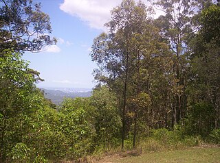
Camp Mountain is a rural locality in the Moreton Bay Region, Queensland, Australia.

Lake Lenthall is a lake created by the Lenthalls Dam in Duckinwilla, Fraser Coast Region, Queensland, Australia. It was named after the pioneering family in the district. It was constructed in 1984 on the head waters of the Burrum River and raised by 2 metres in 2007. As a result of a 518 square kilometre catchment it takes a short time in moderate rain events to fill Lake Lenthall to 100% capacity.

Leyburn is a rural town in the Southern Downs Region and a locality split between the South Downs Region and the Toowoomba Region in Queensland, Australia. In the 2016 census, Leyburn had a population of 476 people.

Mirani is a town and locality in Mackay Region, Queensland, Australia. In the 2016 census, Mirani had a population of 1,541 people.

Forest Hill is a rural town and locality in the Lockyer Valley Region, Queensland, Australia. In the 2016 census, Forest Hill had a population of 968 people.
Cranley is a rural locality in the Toowoomba Region, Queensland, Australia. In the 2016 census, Cranley had a population of 1446 people.

Rosedale is a rural town and locality split between the Gladstone Region and the Bundaberg Region in central Queensland, Australia.
Kurwongbah is a sparsely settled locality in the Moreton Bay Region, Queensland, Australia. In the 2016 census, Kurwongbah had a population of 1,430 people.

Benarkin is a rural town and locality in the South Burnett Region, Queensland, Australia. The nearby town of Blackbutt is the origin of the town and the two towns are often referred to as the joint entity Blackbutt-Benarkin. In the 2016 census, Benarkin had a population of 61 people.

Allan is a rural locality in the Southern Downs Region, Queensland, Australia. It was formerly known as Sandy Creek. In the 2016 census, Allan had a population of 87 people.
The Burrum River is a river located in the Wide Bay-Burnett region of Queensland, Australia.

Hazeldean is a rural locality in the Somerset Region, Queensland, Australia. In the 2016 census, Hazeldean had a population of 262 people.
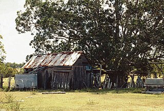
Allan Slab Hut is a heritage-listed slab hut at Warrah Road, Duckinwilla, Fraser Coast Region, Queensland, Australia. It was built c. 1900. It is also known as Price Property. It was added to the Queensland Heritage Register on 28 April 2000.

