Marodian, Queensland

Last updated

Marodian
Queensland
Map of Marodian Goldfield, 1914.jpg
Map of Marodian Goldfield, 1914
Australia Queensland location map.svg
Red pog.svg
Marodian
Coordinates 25°50′44″S152°17′34″E / 25.8455°S 152.2927°E / -25.8455; 152.2927 (Marodian (centre of locality))
Population0 (2021 census) [1]
 • Density0.000/km2 (0.000/sq mi)
Postcode(s) 4570
Area69.5 km2 (26.8 sq mi)
Time zone AEST (UTC+10:00)
Location
LGA(s) Fraser Coast Region
State electorate(s) Maryborough
Federal division(s) Wide Bay
Suburbs around Marodian:
Gigoomgan Gigoomgan Glenbar
Calgoa Marodian Mount Urah
Calgoa Woolooga Glen Echo

Marodian is a rural locality in the Fraser Coast Region, Queensland, Australia. [2] In the 2021 census, Marodian had "no people or a very low population". [1]

Contents

Geography

The Brooweena - Woolooga Road enters the locality from the north (Gigoomgan) and exits to the south (Woolooga). [3]

Almost all of the locality is occupied by the Marodian pastoral station, where the land use is grazing on native vegetation. [3]

History

The locality takes its name from the parish name, which in turn is derived from the name of a pastoral run held by James and Norman Leith Hay in 1852. [4] The pastoral run name might come from the Kabi language word maridhan meaning place of kangaroos. [2]

In 1867, the Marodian area was suspected of having gold due to geological similarities with other gold-bearing areas. [5] There were early finds of alluvial gold at Colo Flats and Yorkey’s Hill. [6] In 1884, the Queensland Surveyor General, A. C. Gregory, continued to promote the likelihood of gold in the Marodian area. [7] In 1901, the Marodian Gold Mining Syndicate dug a shaft down to 350 feet (110 m). [8] [9] [10] In 1902, interest in the goldfield was still low with 109 people on the goldfield compared with over 14,000 on the Gympie goldfields. [11] In 1903, the Marodian Gold Mining Company established a mining lease of 40 acres (16 ha), [12] but operations had ceased by 1904. [13]

Demographics

In the 2016 census, Marodian had "no people or a very low population". [14]

In the 2021 census, Marodian had "no people or a very low population". [1]

Education

There are no schools in Marodian. The nearest government primary schools are: [15]

The nearest government secondary schools are: [15]

Related Research Articles

<span class="mw-page-title-main">Murgon</span> Town in Queensland, Australia

Murgon is a rural town and locality in the South Burnett Region, Queensland, Australia. In the 2016 census, the locality of Murgon had a population of 2,378 people.

<span class="mw-page-title-main">Wide Bay Highway</span>

The Wide Bay Highway is a short state highway of Queensland, Australia running between Goomeri on the Burnett Highway and a junction on the Bruce Highway. From the junction it is 12 kilometres south to Gympie or 69 kilometres north to Maryborough. The length of the highway is 62.6 kilometres. It is a state-controlled regional road.

<span class="mw-page-title-main">Kilkivan, Queensland</span> Town in Queensland, Australia

Kilkivan is a town and locality in the Gympie Region of Queensland, Australia. At the 2016 census, Kilkivan had a population of 713.

<span class="mw-page-title-main">Goomeri</span> Town in Queensland, Australia

Goomeri is a rural town and locality in the Gympie Region, Queensland, Australia. In the 2016 census, the locality of Goomeri had a population of 664 people.

<span class="mw-page-title-main">Shire of Kilkivan</span> Local government area in Queensland, Australia

The Shire of Kilkivan was a local government area about 180 kilometres (112 mi) north-northwest of Brisbane, the state capital of Queensland, Australia. The shire covered an area of 3,263.4 square kilometres (1,260.0 sq mi), and existed from 1886 until its merger with several other local government areas to form the Gympie Region on 15 March 2008.

<span class="mw-page-title-main">Chatsworth, Queensland</span> Suburb of Gympie, Queensland, Australia

Chatsworth is a rural locality in the Gympie Region, Queensland, Australia. In the 2021 census, Chatsworth had a population of 1,353 people.

<span class="mw-page-title-main">Tingoora</span> Town in Queensland, Australia

Tingoora is a rural town and a locality in the South Burnett Region, Queensland, Australia.

<span class="mw-page-title-main">Brooweena, Queensland</span> Town in Queensland, Australia

Brooweena is a rural town and locality in the Fraser Coast Region, Queensland, Australia. In the 2021 census, the locality of Brooweena had a population of 91 people.

<span class="mw-page-title-main">Theebine</span> Town in Queensland, Australia

Theebine is a rural town and locality split between the Gympie Region and the Fraser Coast Region, both in Queensland, Australia.

<span class="mw-page-title-main">Woolooga</span> Town in Queensland, Australia

Woolooga is a rural town and locality in the Gympie Region, Queensland, Australia. In the 2016 census the locality of Woolooga had a population of 247 people.

<span class="mw-page-title-main">Miva, Queensland</span> Town in Queensland, Australia

Miva is a locality split between the Gympie Region and the Fraser Coast Region in Queensland, Australia. In the 2016 census Miva had a population of 57 people.

<span class="mw-page-title-main">Widgee</span> Suburb of Gympie Region, Queensland, Australia

Widgee is a rural locality in the Gympie Region, Queensland, Australia. In the 2021 census, Widgee had a population of 862 people.

<span class="mw-page-title-main">Woolooga Rail Bridge</span> Heritage listed railway bridge in Queensland, Australia

Woolooga Rail Bridge is a heritage-listed railway bridge at Wide Bay Creek on the Theebine - Kilikivan railway line, Woolooga, Gympie Region, Queensland, Australia. It was built in 1884 by Owen McDermott & Co. It was added to the Queensland Heritage Register on 21 October 1992.

Lower Wonga is a rural locality in the Gympie Region, Queensland, Australia. In the 2021 census, Lower Wonga had a population of 310 people.

Bells Bridge is a rural locality in the Gympie Region, Queensland, Australia. In the 2021 census, Bells Bridge had a population of 226 people.

<span class="mw-page-title-main">John O'Connell Bligh</span> Native Police commandant

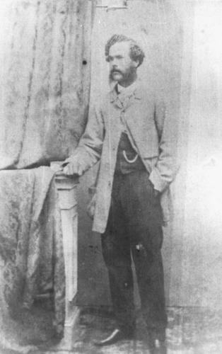
John O'Connell Bligh was a Native Police officer in the British colonies of New South Wales and Queensland. He achieved the rank of Commandant of this colonial paramilitary force from 1861 to 1864. Bligh is probably best known for an incident in Maryborough, where he shot a number of Aboriginal Australians along the main street and into the adjoining Mary River. After retiring from the Native Police, Bligh became a police magistrate in the towns of Gayndah and Gympie.

<span class="mw-page-title-main">Cinnabar, Queensland</span> Suburb of Gympie Region, Queensland, Australia

Cinnabar is a rural locality in the Gympie Region, Queensland, Australia. In the 2021 census, Cinnabar had a population of 83 people.

<span class="mw-page-title-main">Munna Creek</span> Suburb of Fraser Coast Region, Queensland, Australia

Munna Creek is a locality split between the Fraser Coast Region and the Gympie Region, in Queensland, Australia. In the 2016 census, Munna Creek had a population of 23 people.

Monal is a locality in the North Burnett Region, Queensland, Australia. In the 2021 census, Monal had a population of 34 people.

Paterson is a rural locality in the Fraser Coast Region, Queensland, Australia. In the 2021 census, Paterson had a population of 157 people.

References

  1. 1 2 3 Australian Bureau of Statistics (28 June 2022). "Marodian (SAL)". 2021 Census QuickStats. Retrieved 28 February 2023. OOjs UI icon edit-ltr-progressive.svg
  2. 1 2 "Marodian – locality in Fraser Coast Region (entry 46660)". Queensland Place Names. Queensland Government . Retrieved 10 June 2019.
  3. 1 2 "Queensland Globe". State of Queensland . Retrieved 8 November 2023.
  4. "Colonial Extracts". The Moreton Bay Courier . Vol. VI, no. 297. Queensland, Australia. 21 February 1852. p. 4. Archived from the original on 8 November 2023. Retrieved 20 October 2019 via National Library of Australia.
  5. "The Miner". The Queenslander . Vol. II, no. 94. Queensland, Australia. 16 November 1867. p. 3. Archived from the original on 8 November 2023. Retrieved 8 November 2023 via National Library of Australia.
  6. "Wide Bay Burnett Minerals Region Investment Attraction Strategy Project (Stages 1 and 2) : Final Report Volume 1" (PDF). Wide Bay Burnett Regional Organisation of Councils. August 2020. p. 44. Archived (PDF) from the original on 5 March 2023. Retrieved 8 November 2023.
  7. "OUR GOLD DEPOSITS". Maryborough Chronicle, Wide Bay And Burnett Advertiser . No. 3, 485. Queensland, Australia. 17 September 1884. p. 2. Retrieved 9 November 2023 via National Library of Australia.
  8. "Advertising". Gympie Times and Mary River Mining Gazette . Vol. XXXIII, no. 4169. Queensland, Australia. 26 January 1901. p. 2. Retrieved 9 November 2023 via National Library of Australia.
  9. "Running Creek". Gympie Times and Mary River Mining Gazette . Vol. XXXIII, no. 4204. Queensland, Australia. 18 April 1901. p. 3. Retrieved 9 November 2023 via National Library of Australia.
  10. "Marodian Goldfield". Gympie Times and Mary River Mining Gazette . Vol. XXXIII, no. 4301. Queensland, Australia. 30 November 1901. p. 5. Retrieved 9 November 2023 via National Library of Australia.
  11. "Our Goldfields Populations". Morning Post (Cairns) . Vol. 13, no. 3. Queensland, Australia. 10 January 1902. p. 2. Retrieved 9 November 2023 via National Library of Australia.
  12. "Notes and News". Gympie Times And Mary River Mining Gazette . Vol. XXIX, no. 3650. Queensland, Australia. 23 September 1897. p. 3. Archived from the original on 8 November 2023. Retrieved 8 November 2023 via National Library of Australia.
  13. "Norton Goldfield (entry 602491)". Queensland Heritage Register . Queensland Heritage Council. Retrieved 1 August 2014.
  14. Australian Bureau of Statistics (27 June 2017). "Marodian (SSC)". 2016 Census QuickStats. Retrieved 20 October 2018. OOjs UI icon edit-ltr-progressive.svg
  15. 1 2 "Layers: Locality; Schools and school catchments". Queensland Globe. Queensland Government. Archived from the original on 19 December 2017. Retrieved 8 November 2023.