
The Shire of Woocoo was a local government area located in the Wide Bay–Burnett region of Queensland, Australia, containing the rural residential area to the west of the town of Maryborough, and surrounding countryside. The shire covered an area of 2,007.9 square kilometres (775.3 sq mi), and existed as a local government entity from 1914 until 2008, when it was amalgamated with the City of Maryborough, City of Hervey Bay and the 1st and 2nd divisions of the Shire of Tiaro to form the Fraser Coast Region.

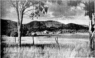
Brooweena is a rural town and locality in the Fraser Coast Region, Queensland, Australia. In the 2016 census, Brooweena had a population of 104 people.
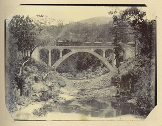
The Mungar Junction to Monto railway line is a 267-kilometre (166 mi) railway in Queensland, Australia. Progressively opened in eleven stages between 1889 and 1928 the line branched from the North Coast line at Mungar Junction a short distance west of Maryborough and followed a westerly route towards Biggenden and Gayndah before turning north via Mundubbera and Eidsvold to Monto. It is also known as the Gayndah Monto Branch Railway.

Tinana is a rural town and locality in the Fraser Coast Region, Queensland, Australia. In the 2016 census the locality of Tinana had a population of 5,476 people.

Booroobin is a locality split between the Moreton Bay Region and the Sunshine Coast Region in Queensland, Australia. In the 2016 census, Booroobin had a population of 260.
Bouldercombe is a rural town and locality in the Rockhampton Region, Queensland, Australia. In the 2016 census, the locality of Bouldercombe had a population of 1,085 people.

Eton is a rural town and locality in the Mackay Region, Queensland, Australia. In the 2016 census, the locality of Eton had a population of 679 people.

Bauple is a rural town and locality in the Fraser Coast Region, Queensland, Australia. In the 2016 census the locality of Bauple had a population of 644 people.
Yalboroo is a rural town and locality in the Mackay Region, Queensland, Australia. In the 2016 census, the locality of Yalboroo had a population of 170 people.
Thornton is a rural locality in the Lockyer Valley Region, Queensland, Australia. In the 2016 census, Thornton had a population of 201 people.
Rockmount is a rural locality in the Lockyer Valley Region, Queensland, Australia. In the 2016 census, Rockmount had a population of 87 people.
Aramara is a rural town and locality in the Fraser Coast Region, Queensland, Australia. In the 2016 census, the locality of Aramara had a population of 57 people.
North Aramara is a rural locality in the Fraser Coast Region, Queensland, Australia. In the 2016 census, North Aramara had a population of 35 people.
Boompa is a rural locality in the Fraser Coast Region, Queensland, Australia. In the 2016 census, Boompa had a population of 83 people.

Teebar is a locality in the Fraser Coast Region, Queensland, Australia. In the 2016 census, Teebar had a population of 43 people.
Gregors Creek is a rural locality in the Somerset Region, Queensland, Australia. In the 2016 census, Gregors Creek had a population of 96 people.
Mount Urah is a rural locality in the Fraser Coast Region, Queensland, Australia. In the 2016 census, Mount Urah had a population of 21 people.
Gungaloon is a locality in the Fraser Coast Region, Queensland, Australia. In the 2016 census, Gungaloon had a population of 33 people.
Dunmora is a rural locality in the Fraser Coast Region, Queensland, Australia. In the 2016 census, Dunmora had a population of 222 people.
Maryborough–Biggenden Road is an 83.4 kilometres (51.8 mi) road route in the Fraser Coast and North Burnett regions of Queensland, Australia. The entire route is signed as State Route 86.
