
Maryborough is a city and a suburb in the Fraser Coast Region, Queensland, Australia. In the 2021 census, the suburb of Maryborough had a population of 15,287 people.

Biggenden is a rural town and locality in the North Burnett Region, Queensland, Australia. In the 2021 census, the locality of Biggenden had a population of 788 people.

Goomeri is a rural town and locality in the Gympie Region, Queensland, Australia. In the 2021 census, the locality of Goomeri had a population of 677 people.

The Shire of Woocoo was a local government area located in the Wide Bay–Burnett region of Queensland, Australia, containing the rural residential area to the west of the town of Maryborough, and surrounding countryside. The shire covered an area of 2,007.9 square kilometres (775.3 sq mi), and existed as a local government entity from 1914 until 2008, when it was amalgamated with the City of Maryborough, City of Hervey Bay and the 1st and 2nd divisions of the Shire of Tiaro to form the Fraser Coast Region.
Woocoo is a rural locality in the Fraser Coast Region, Queensland, Australia. In the 2021 census, Woocoo had a population of 56 people.

Howard is a rural town and locality in the Fraser Coast Region, Queensland, Australia. It is a southern boundary of the Dundaburra peoples of the Northern Kabi Kabi Isis districts and surrounds. It is located 284 kilometres (176 mi) north of Brisbane and 37 kilometres (23 mi) west of Hervey Bay. In the 2021 census, the locality of Howard had a population of 1,394 people.

The Fraser Coast Region is a local government area in the Wide Bay–Burnett region of Queensland, Australia, about 250 kilometres (160 mi) north of Brisbane, the state capital. It is centred on the twin cities of Hervey Bay and Maryborough and also contains K'gari. It was created in 2008 from a merger of the Cities of Maryborough and Hervey Bay and the Shires of Woocoo and most of Tiaro. The resident population at the 2021 census was 111,032 and the estimated population in 2023 was 117,940.

Brooweena is a rural town and locality in the Fraser Coast Region, Queensland, Australia. In the 2021 census, the locality of Brooweena had a population of 91 people.
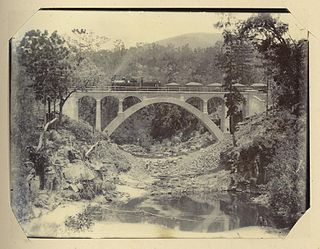
The Mungar Junction to Monto railway line is a 267-kilometre (166 mi) railway in Queensland, Australia. Progressively opened in eleven stages between 1889 and 1928 the line branched from the North Coast line at Mungar Junction a short distance west of Maryborough and followed a westerly route towards Biggenden and Gayndah before turning north via Mundubbera and Eidsvold to Monto. It is also known as the Gayndah Monto Branch Railway. In 2012, the line was officially closed.

Tinana is a rural town and locality in the Fraser Coast Region, Queensland, Australia. In the 2021 census, the locality of Tinana had a population of 5,872 people.

Coalstoun Lakes is a rural town and locality in the North Burnett Region, Queensland, Australia. In the 2021 census, the locality of Coalstoun Lakes had a population of 99 people.

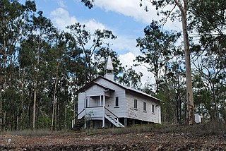
Brooweena War Memorial is a heritage-listed memorial at Smith Crescent, Brooweena, Fraser Coast Region, Queensland, Australia. It was built in 1922 by F W Webb. It was added to the Queensland Heritage Register on 21 October 1992.

Didcot is a rural locality in the North Burnett Region, Queensland, Australia. In the 2021 census, Didcot had a population of 85 people.
Aramara is a rural town and locality in the Fraser Coast Region, Queensland, Australia. In the 2021 census, the locality of Aramara had a population of 71 people.
North Aramara is a rural locality in the Fraser Coast Region, Queensland, Australia. In the 2021 census, North Aramara had a population of 45 people.

Teebar is a rural locality in the Fraser Coast Region, Queensland, Australia. In the 2021 census, Teebar had a population of 59 people.
Gungaloon is a locality in the Fraser Coast Region, Queensland, Australia. In the 2021 census, Gungaloon had a population of 27 people.
Dunmora is a rural locality in the Fraser Coast Region, Queensland, Australia. In the 2021 census, Dunmora had a population of 281 people.
Wilson Valley is a rural locality in the North Burnett Region, Queensland, Australia. In the 2021 census, Wilson Valley had a population of 20 people.
Maryborough–Biggenden Road is an 83.4 kilometres (51.8 mi) road route in the Fraser Coast and North Burnett regions of Queensland, Australia. The entire route is signed as State Route 86.

