Coalstoun Lakes Queensland | |||||||||||||||
---|---|---|---|---|---|---|---|---|---|---|---|---|---|---|---|
Coordinates | 25°36′48″S151°53′24″E / 25.6133°S 151.89°E | ||||||||||||||
Population | 99 (2021 census) [2] | ||||||||||||||
• Density | 1.908/km2 (4.940/sq mi) | ||||||||||||||
Postcode(s) | 4621 | ||||||||||||||
Area | 51.9 km2 (20.0 sq mi) | ||||||||||||||
Time zone | AEST (UTC+10:00) | ||||||||||||||
Location | |||||||||||||||
LGA(s) | North Burnett Region | ||||||||||||||
State electorate(s) | Callide | ||||||||||||||
Federal division(s) | Flynn | ||||||||||||||
|
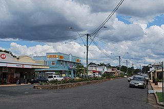
Coalstoun Lakes is a rural town and locality in the North Burnett Region, Queensland, Australia. [3] [4] In the 2021 census, the locality of Coalstoun Lakes had a population of 99 people. [2]
The Isis Highway passes through the locality from north-east to south, also passing through the town (where it is called Main Street). The Coalstoun Lakes National Park is in the north-east of the locality. [5]
The lakes (from which the district takes its name) were named by local pioneer, Nugent Wade Brown, in 1894. [6] There are various theories as to the origin of the name.
Coalstoun Lakes Cemetery is believed to be older than the town itself, as its earliest surviving inscription on a grave is dated 1899. [12]
Coalstoun Lakes State School opened on 25 July 1910. [13]
Brigalow Creek State School opened on 3 December 1913 and closed on 1924. [14]
Coalstoun Lakes Community Hall was originally built in 1916. After World War I, it was extended and renamed the Coalstoun Lakes Memorial Hall to commemorate those who served and died in the war. [15] [12]
Mount Harvey State School opened on 24 January 1921 and closed on 31 October 1948. [14]
Coalstoun Lakes Post Office opened on 1 July 1927 (a receiving office had been open from 1910) and closed in 1976. [16]
On 31 July 1932 Archbishop James Duhig opened the Catholic church in Coalstoun Lakes. [17]
St Thomas' Anglican Church was dedicated on 30 December 1934 by Bishop Horace Henry Dixon. [18] [19]
In the 2011 census, the locality of Coalstoun Lakes had a population of 423 people. [20]
In the 2016 census, the locality of Coalstoun Lakes had a population of 114 people. [21]
In the 2021 census, the locality of Coalstoun Lakes had a population of 99 people. [2]
Coalstoun Lakes has a number of heritage-listed sites, including:
Coalstoun Lakes State School is a government primary (Prep-6) school for boys and girls at 3 Main Street ( 25°36′44″S151°53′24″E / 25.6121°S 151.8901°E ). [22] [23] In 2018, the school had an enrolment of 10 students with 2 teachers (1 full-time equivalent) and 5 non-teaching staff (2 full-time equivalent). [24]
There is no secondary school in Coalstoun Lakes. The nearest secondary schools are Biggenden State School (to Year 10) in neighbouring Biggenden to the north-east and Burnett State College (to Year 12) in Gayndah to the west. [5]
Coalstoun Lakes Memorial Hall is at 34 Main Street ( 25°36′56″S151°53′23″E / 25.6155°S 151.8896°E ). [12] [25] The Coalstoun Lakes Rural Fire Brigade operates from the shed at the rear of the hall access from Glenview Street. [26]
St Thomas' Community Church is at 11 Main Street ( 25°36′50″S151°53′25″E / 25.61377°S 151.89031°E ); it is a former Anglican Church. [18]
Coalstoun Lakes Cemetery is at the end of Coalstoun Lakes Cemetery Road ( 25°36′53″S151°53′12″E / 25.6148°S 151.8867°E ). [27] [28]
Coalstoun Lakes is a national park in Queensland, Australia, 236 km (147 mi) northwest of Brisbane. It features a volcano, Mount Le Brun, which has two craters that contain intermittent crater lakes. Mount Le Brun is one of the youngest volcanic formations in Australia, although it was formed more than 600,000 years ago. Coalstoun Lakes is Queensland's smallest national park.
Biggenden is a rural town and locality in the North Burnett Region, Queensland, Australia. In the 2021 census, the locality of Biggenden had a population of 788 people.
Mount Perry is a rural town and locality in the North Burnett Region, Queensland, Australia. In the 2021 census, the locality of Mount Perry had a population of 487 people.
Brooweena is a rural town and locality in the Fraser Coast Region, Queensland, Australia. In the 2021 census, the locality of Brooweena had a population of 91 people.
Degilbo is a rural town and locality in the North Burnett Region, Queensland, Australia. In the 2021 census, the locality of Degilbo had a population of 182 people.
Booie is a rural locality in the South Burnett Region, Queensland, Australia. In the 2021 census, Booie had a population of 1,094 people.
Didcot is a rural locality in the North Burnett Region, Queensland, Australia. In the 2021 census, Didcot had a population of 85 people.
Wetheron is a rural town and locality in the North Burnett Region, Queensland, Australia. In the 2021 census, the locality of Wetheron had a population of 40 people.
Boondooma is a rural locality in the South Burnett Region, Queensland, Australia. In the 2021 census, Boondooma had a population of 70 people.
Binjour is a rural locality in the North Burnett Region, Queensland, Australia. In the 2021 census, Binjour had a population of 86 people.
Dallarnil is a rural town and locality in the North Burnett Region, Queensland, Australia. In the 2021 census, the locality of Dallarnil had a population of 245 people.
Coringa is a rural locality in the North Burnett Region, Queensland, Australia. In the 2021 census, Coringa had a population of 86 people.
Moonford is a rural town and locality in the North Burnett Region, Queensland, Australia. In the 2021 census, the locality of Moonford had a population of 162 people.
Mount Steadman is a rural locality in the North Burnett Region, Queensland, Australia. In the 2021 census, Mount Steadman had "no people or a very low population".
Good Night is a rural locality split between the Bundaberg Region and the North Burnett Region, Queensland, Australia. It is also written as Goodnight. In the 2021 census, Good Night had a population of 151 people.
Ban Ban is a rural locality in the North Burnett Region, Queensland, Australia. In the 2021 census, Ban Ban had a population of 25 people.
Cania is a locality in the North Burnett Region, Queensland, Australia. In the 2021 census, Cania had a population of 27 people.
Barlyne is a locality in the North Burnett Region, Queensland, Australia. In the 2021 census, Barlyne had "no people or a very low population".
Monal is a locality in the North Burnett Region, Queensland, Australia. In the 2021 census, Monal had a population of 34 people.
Wilson Valley is a rural locality in the North Burnett Region, Queensland, Australia. In the 2021 census, Wilson Valley had a population of 20 people.
Colstoun is also the Ancestral Home of the Broun Family.