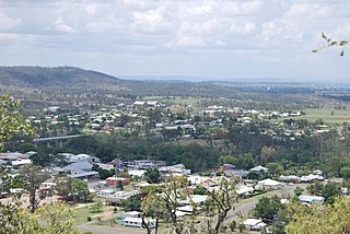
Gayndah is a town and locality in the North Burnett Region, Queensland, Australia. It is the administrative centre for the North Burnett Region. In the 2021 census, the locality of Gayndah had a population of 1,949 people.
Monogorilby is a locality in the North Burnett Region, Queensland, Australia. The neighbourhood of Allies Creek is located in the south-east of Monogorilby.

Bunya Mountains is a locality split between the Western Downs Region and the South Burnett Region, Queensland, Australia. The town of Mount Mowbullan is located on the boundary of Bunya Mountains and the enclosed locality of Mowbullan. In the 2021 census, Bunya Mountains had a population of 110 people.
Derri Derra is a rural locality in the North Burnett Region, Queensland, Australia. In the 2021 census, Derri Derra had a population of 115 people.
Ellesmere is a rural locality in the South Burnett Region, Queensland, Australia. In the 2021 census, Ellesmere had a population of 334 people.
Glenrae is a rural locality in the North Burnett Region, Queensland, Australia. In the 2021 census, Glenrae had a population of 63 people.
Goodger is a rural locality in the South Burnett Region, Queensland, Australia. In the 2021 census, Goodger had a population of 176 people.
Mount Steadman is a rural locality in the North Burnett Region, Queensland, Australia. In the 2021 census, Mount Steadman had "no people or a very low population".
Mundowran is a rural locality in the North Burnett Region, Queensland, Australia. In the 2021 census, Mundowran had a population of 119 people.

Stonelands is a rural locality in the South Burnett Region, Queensland, Australia. In the 2021 census, Stonelands had a population of 34 people.
Three Moon is a rural locality in the North Burnett Region, Queensland, Australia. In the 2021 census, Three Moon had a population of 178 people.

Mount Debateable is a rural locality in the North Burnett Region, Queensland, Australia. In the 2021 census, Mount Debateable had a population of 40 people.
Ban Ban is a rural locality in the North Burnett Region, Queensland, Australia. In the 2021 census, Ban Ban had a population of 25 people.
Bon Accord is a rural locality in the North Burnett Region, Queensland, Australia. In the 2021 census, Bon Accord had a population of 29 people.
Boynewood is a rural locality in the North Burnett Region, Queensland, Australia. In the 2021 census, Boynewood had a population of 138 people.
Dirnbir is a rural locality in the North Burnett Region, Queensland, Australia. In the 2021 census, Dirnbir had a population of 59 people.
Branch Creek is a locality in the North Burnett Region, Queensland, Australia. In the 2021 census, Branch Creek had a population of 33 people.
Yenda is a rural locality in the North Burnett Region, Queensland, Australia. In the 2021 census, Yenda had a population of 16 people.
Dunmora is a rural locality in the Fraser Coast Region, Queensland, Australia. In the 2021 census, Dunmora had a population of 281 people.
Wilson Valley is a rural locality in the North Burnett Region, Queensland, Australia. In the 2021 census, Wilson Valley had a population of 20 people.
