Kalpowar

Last updated

Map all coordinates using: OpenStreetMap
Kalpowar
Queensland
Kalpowar Forest Street.JPG
Forest St, the main street of Kalpowar
Australia Queensland location map.svg
Red pog.svg
Kalpowar
Coordinates 24°41′42″S151°18′18″E / 24.695°S 151.305°E / -24.695; 151.305 (Kalpowar (town centre))
Population67 (2016 census) [1]
 • Density0.2090/km2 (0.541/sq mi)
Postcode(s) 4630
Area320.6 km2 (123.8 sq mi)
Location
LGA(s)
State electorate(s) Callide
Federal division(s) Flynn
Localities around Kalpowar:
Boyne Valley Boyne Valley Dalga
Monal Kalpowar Dalga
Bancroft Yarrol Molangul

Kalpowar is a town in the North Burnett Region and a locality split between the North Burnett Region and the Bundaberg Region, in Queensland, Australia. [2] [3] [4] In the 2016 census, the locality of Kalpowar had a population of 67 people. [1]

Contents

Geography

The Gladstone–Monto Road runs through from north-west to south-west. [5]

Large areas from the north to the south of the locality are within the Kalpowar State Forest with parts of the north-east of the locality in the Borilla State Forest. Immediately south of the town of Kalpowar in the west of the locality are two small state forests: New Cannindah State Forest and Splinter Creek State Forest. [6]

Kalpowar has the following mountains:

History

The town's name derives from the railway station name assigned by the Queensland Railways Department on 30 January 1928, which was an Aboriginal word meaning either pine tree or copper. [2]

Many Peaks Provisional School opened on 23 October 1922 as part of the railway construction camp (57 Mile Camp) for the Gladstone to Monto railway line. As the camp moved to be at the area of the current construction, the school also relocated and renamed with it. In 1923 it was relocated south to the 63 Mile Camp. In 1926 it moved south to 67 Mile Camp and was renamed Barrimoon Provisional School (Barrimoon being the name of the railway station there). In 1927 it moved again to 74 Mile Camp and its name was changed in 1928 to Kalpowar Provisional School. In 1929 it moved to 82 Mile Camp and in September 1930 it was renamed Bancroft Provisional School. On 1 August 1931 it became Bancroft State School and remained there permanently until its closure on 31 December 1998. [11]

Sixty-six Mile Camp Provisional School opened on 9 May 1923. Like the other construction camp school it relocated and renamed a number of times as the camp relocated to the current work area. In 1926 it became Seventy Mile Camp Provisional School. In 1927 it became Seventy-two Mile Camp Provisional School In 1929 it became Kalpowar Provisional School. In 1931 it became Mount Cannindah Provisional School. In 1933 it became Kalpowar Provisional School once again. It later became Kalpowar State School. It closed in 1997. [11] [12] It was on a 4-acre (1.6 ha) site at 2-6 Pine Street ( 24°41′37″S151°18′15″E / 24.6936°S 151.3041°E / -24.6936; 151.3041 (Kalpowar State School (former)) ). [13]

In the 2016 census, the locality of Kalpowar had a population of 67 people. [1]

Heritage listings

Kalpowar has a number of heritage-listed sites, including:

Education

There are no schools in Kalpowar. The nearest government primary schools are Builyan State School in neighbouring Boyne Valley to the north and Monto State School in Monto to the south-west. The nearest government secondary school is Monto State High School, also in Monto, but this school is sufficiently distant from some parts of Kalpowar that distance education and boarding schools are other options. [6]

Attractions

Bills Window Lookout is on Kalpowar Forest Drive ( 24°42′39″S151°20′47″E / 24.7107°S 151.3463°E / -24.7107; 151.3463 (Bills Window Lookout) ). [15] There is a view over the Kolan River catchment. [16]

The Dawes Range Tunnel section of the Boyne Burnett Inland Rail Trail was opened on 11 September 2021. The 26.28- kilometre (16.33  mi ) section starts at Barrimoon Siding, Kalpowar and finishes at Builyan, Boyne Valley. [17] This section contains 6 tunnels between Barrimoon Siding and Golembil Siding. [18] [19] It also passes the historic township of Many Peaks with its Local Heritage listed attractions - the Many Peaks Railway Complex, [20] Many Peaks Railway Dam [21] and Many Peaks Road Bridge. [22]

The Bicentennial National Trail passes through Kalpowar in an east-west direction. [23]

Related Research Articles

<span class="mw-page-title-main">Monto, Queensland</span> Town in Queensland, Australia

Monto is a rural town and locality in the North Burnett Region, Queensland, Australia. In the 2021 census, the locality of Monto had a population of 1,156 people.

<span class="mw-page-title-main">Mulgildie</span> Town in Queensland, Australia

Mulgildie is a rural town and locality in the North Burnett Region, Queensland, Australia. In the 2016 census, Mulgildie had a population of 174 people.

<span class="mw-page-title-main">Boyne Valley, Queensland</span> Suburb of Gladstone Region, Queensland, Australia

The Boyne Valley is a rural locality in Gladstone Region, Queensland, Australia. The locality contains four small towns: Nagoorin, Ubobo, Builyan, and Many Peaks. In the 2021 census, Boyne Valley had a population of 301 people.

<span class="mw-page-title-main">Nagoorin</span> Town in Queensland, Australia

Nagoorin is a rural town in Gladstone Region, Queensland, Australia. It is one of four small townships within the locality of Boyne Valley along with Ubobo, Builyan, and Many Peaks.

<span class="mw-page-title-main">Ubobo</span> Town in Queensland, Australia

Ubobo is a rural town in the locality of Boyne Valley in the Gladstone Region, Queensland, Australia.

<span class="mw-page-title-main">Builyan, Queensland</span> Town in Queensland, Australia

Builyan is a town in Gladstone Region, Central Queensland, Australia. It is one of four small townships within the locality of Boyne Valley along with Nagoorin, Ubobo, and Many Peaks.

<span class="mw-page-title-main">Many Peaks, Queensland</span> Town in Queensland, Australia

Many Peaks is a town in Gladstone Region in Queensland, Australia. It is one of four small townships within the locality of Boyne Valley along with Nagoorin, Builyan and Ubobo.

<span class="mw-page-title-main">Mungar Junction to Monto railway line</span> Former railway line in Queensland, Australia

The Mungar Junction to Monto railway line is a 267-kilometre (166 mi) railway in Queensland, Australia. Progressively opened in eleven stages between 1889 and 1928 the line branched from the North Coast line at Mungar Junction a short distance west of Maryborough and followed a westerly route towards Biggenden and Gayndah before turning north via Mundubbera and Eidsvold to Monto. It is also known as the Gayndah Monto Branch Railway. In 2012, the line was officially closed.

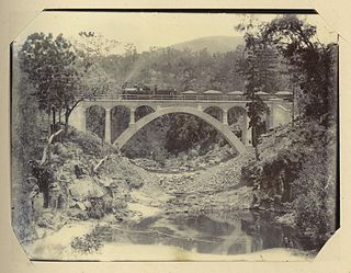
Byellee to Monto Branch Railway was a branch railway that branched off the Boyne Valley west of Gladstone in Queensland, Australia.The Boyne Valley region was predominantly a dairying region and a railway had little justification. However a branch was justified in 1906 on the basis of large traffic in timber, fuel, limestone and flexing ores. Progressively opened between 1910 and 1931 the line branched from the North Coast line at Byellee a short distance west of Gladstone and struck a south-westerly route via Many Peaks and Mungungo to Monto.

<span class="mw-page-title-main">Didcot, Queensland</span> Suburb of North Burnett Region, Queensland, Australia

Didcot is a rural locality in the North Burnett Region, Queensland, Australia. In the 2016 census Didcot had a population of 60 people.

Boynedale is a rural locality in the Gladstone Region, Queensland, Australia. In the 2016 census, Boynedale had a population of 17 people.

Langley is a rural locality in the North Burnett Region, Queensland, Australia.

<span class="mw-page-title-main">Bancroft, Queensland</span> Suburb of North Burnett Region, Queensland, Australia

Bancroft is a rural locality in the North Burnett Region, Queensland, Australia. In the 2016 census, Bancroft had a population of 96 people.

Bukali is a rural locality in the North Burnett Region, Queensland, Australia. In the 2021 census, Bukali had a population of 57 people.

Kapaldo is a rural town and locality in the North Burnett Region, Queensland, Australia. In the 2016 census, the locality of Kapaldo had a population of 43 people.

<span class="mw-page-title-main">Mungungo</span> Town in Queensland, Australia

Mungungo is a rural town and locality in the North Burnett Region, Queensland, Australia. In the 2016 census, the locality of Mungungo had a population of 77 people.

Dirnbir is a rural locality in the North Burnett Region, Queensland, Australia. In the 2021 census, Dirnbir had a population of 59 people.

Monal is a locality in the North Burnett Region, Queensland, Australia. In the 2021 census, Monal had a population of 34 people.

Gladstone–Monto Road is a 132 kilometres (82 mi) road route in the Gladstone and North Burnett regions of Queensland, Australia. The entire route is signed as State Route 69.

The Boyne Burnett Inland Rail Trail is a recreational route for walkers, cyclists and horse riders from Taragoola to Gayndah. It uses the closed Gladstone to Monto and Mungar Junction to Monto railway corridors in Queensland, Australia.

References

  1. 1 2 3 Australian Bureau of Statistics (27 June 2017). "Kalpowar (SSC)". 2016 Census QuickStats. Retrieved 20 October 2018. OOjs UI icon edit-ltr-progressive.svg
  2. 1 2 "Kalpowar – town in North Burnett Region (entry 17613)". Queensland Place Names. Queensland Government . Retrieved 28 December 2017.
  3. "Kalpowar – locality in North Burnett Region (entry 45375)". Queensland Place Names. Queensland Government . Retrieved 28 December 2017.
  4. "Kalpowar – locality in Bundaberg Region (entry 44733)". Queensland Place Names. Queensland Government . Retrieved 28 December 2017.
  5. Kalpowar, Queensland (Map). Google Maps. Archived from the original on 2 May 2022. Retrieved 29 October 2021.
  6. 1 2 "Queensland Globe". State of Queensland . Retrieved 1 May 2022.
  7. 1 2 3 "Mountain peaks and capes - Queensland". Queensland Open Data. Queensland Government. 12 November 2020. Archived from the original on 25 November 2020. Retrieved 25 November 2020.
  8. "Mount Bucanally – mountain in North Burnett Region (entry 4857)". Queensland Place Names. Queensland Government . Retrieved 25 November 2020.
  9. "Mount Fort William – mountain in Bundaberg Region (entry 12932)". Queensland Place Names. Queensland Government . Retrieved 25 November 2020.
  10. "The Monument – mountain in North Burnett Region (entry 34029)". Queensland Place Names. Queensland Government . Retrieved 25 November 2020.
  11. 1 2 Queensland Family History Society (2010), Queensland schools past and present (Version 1.01 ed.), Queensland Family History Society, ISBN   978-1-921171-26-0
  12. "Queensland state school - centre closures" (PDF). Queensland Government . 20 August 2013. Archived (PDF) from the original on 20 March 2022. Retrieved 7 April 2022.
  13. "Town of Kalpowar" (Map). Queensland Government. 1964. Archived from the original on 28 December 2017. Retrieved 2 May 2022.
  14. "North Burnett Local Heritage Register" (PDF). North Burnett Regional Council. Archived (PDF) from the original on 16 August 2019. Retrieved 16 August 2019.
  15. "Tourist points - Queensland". Queensland Open Data. Queensland Government. 18 November 2020. Archived from the original on 24 November 2020. Retrieved 24 November 2020.
  16. "Kalpowar State Forest". austhrutime.com. Archived from the original on 7 March 2008. Retrieved 2 May 2022.
  17. McLachlan, Mark (20 August 2022). "Interactive Maps, Dawes Range Section, BBIRT". Boyne Burnett Inland Rail Trail . Retrieved 28 September 2022.
  18. McLachlan, Mark (19 June 2018). "Railway Tunnels, Dawes Range between Golembil and Barrimoon sidings". Boyne Burnett Inland Rail Trail . Retrieved 28 September 2022.
  19. Billing, Amy. "Local Heritage Register". Gladstone Regional Council . Many Peaks / Barrimoon Railway Tunnels. Retrieved 28 September 2022.
  20. Billing, Amy. "Local Heritage Register". Gladstone Regional Council . Many Peaks Railway Complex. Retrieved 28 September 2022.
  21. Billing, Amy. "Local Heritage Register". Gladstone Regional Council . Many Peaks Railway Dam. Retrieved 28 September 2022.
  22. Billing, Amy. "Local Heritage Register". Gladstone Regional Council . Many Peaks Road Bridge. Retrieved 28 September 2022.
  23. "Regional Road Map NORTH BURNETT" (PDF). North Burnett Regional Council (6 ed.). 2018. Retrieved 20 October 2022.

Further reading