Welcome Creek

Last updated

Map all coordinates using: OpenStreetMap  
Download coordinates as: KML
Welcome Creek
Queensland
Australia Queensland location map.svg
Red pog.svg
Welcome Creek
Coordinates 24°46′20″S152°15′41″E / 24.7722°S 152.2613°E / -24.7722; 152.2613 (Welcome Creek (centre of locality)) Coordinates: 24°46′20″S152°15′41″E / 24.7722°S 152.2613°E / -24.7722; 152.2613 (Welcome Creek (centre of locality))
Population445 (2016 census) [1]
 • Density9.549/km2 (24.73/sq mi)
Postcode(s) 4670
Area46.6 km2 (18.0 sq mi)
Time zone AEST (UTC+10:00)
Location
LGA(s) Bundaberg Region
State electorate(s) Burnett
Federal division(s) Flynn
Suburbs around Welcome Creek:
Moorland Moore Park Beach Moore Park Beach
Moorland Welcome Creek Fairymead
Meadowvale Meadowvale Gooburrum

Welcome Creek is a rural locality in the Bundaberg Region, Queensland, Australia. [2] In the 2016 census, Welcome Creek had a population of 445 people. [1]

Contents

Geography

The locality takes its name from the watercourse ( 24°46′00″S152°18′00″E / 24.7666°S 152.3°E / -24.7666; 152.3 (Welcome Creek) ). [3]

North Gooburrum is a neighbourhood in the north-west of the locality ( 24°45′55″S152°15′04″E / 24.7653°S 152.2510°E / -24.7653; 152.2510 (North Gooburrum (neighbourhood)) ). [4] [5]

The land use is agricultural, predominately irrigated horticulture with some sugarcane plantations in the east of the locality and some grazing on native vegetation in the north of the locality. [5]

History

Welcome Creek State School opened on 21 May 1931 and closed on 31 December 2003. [6] [7] After closure, the students were transferred to Moore Park State School in neighbouring Moore Park Beach. [6] The school was located at 669 Moore Park Road ( 24°46′11″S152°16′45″E / 24.7697°S 152.2792°E / -24.7697; 152.2792 (Welcome Creek State School (former)) ). [8] [9] [5]

Agnew School opened on 3 February 2003 in Boundary Street, South Bundaberg, one of several Agnew Schools operated by the Plymouth Brethren Christian Church (sometimes called the Exclusive Brethren) in Queensland. By 2006 the school needed more space and in mid-2006 the church purchased the former Welcome School State School from the Queensland Government and relocated the Agnew School to that site ( 24°46′12″S152°16′45″E / 24.7699°S 152.2792°E / -24.7699; 152.2792 (Agnew School (former Bundaberg campus)) ). [10] However, in 2014 with student numbers at 30-40 students, it was decided to close the school and transport the students by wifi-equipped bus each day to the Agnew School in Maryborough. [6] [11] On 24 December 2020, the site was sold for $925,000. [12]

In the 2016 census, Welcome Creek had a population of 445 people. [1]

Education

There are no schools in Welcome Creek. The nearest government primary schools are Moore Park State School in neighbouring Moore Park Beach to the north and Gooburrum State School in neighbouring Gooburrum to the south-east. The nearest government secondary school is Bundaberg North State High School in Bundaberg North to the south-east. [5]

Amenities

Welcome Creek Hall is at 687 Moore Park Road ( 24°46′16″S152°16′47″E / 24.7712°S 152.2796°E / -24.7712; 152.2796 (Welcome Creek Hall) ). [8]

Related Research Articles

Bargara, Queensland Town in Queensland, Australia

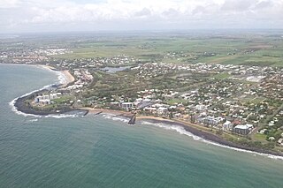
Bargara is a coastal town and suburb in the Bundaberg Region, Queensland, Australia. In the 2016 census the suburb of Bargara had a population of 7,485 people.

Shire of Burnett Local government area in Queensland, Australia

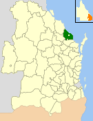
The Shire of Burnett was a local government area located in the Wide Bay–Burnett region of Queensland, Australia. It surrounded, but did not include, the regional city of Bundaberg, and covered an area of 2,000.8 square kilometres (772.5 sq mi). It existed as a local government entity from its creation through the amalgamation of the Shire of Gooburrum and the Shire of Woongarra in 1994 until 2008, when it amalgamated with the City of Bundaberg and other councils in the region to form the Bundaberg Region.

Burnett Heads, Queensland Town in Queensland, Australia

Burnett Heads is a coastal town and locality in the Bundaberg Region, Queensland, Australia. In the 2016 census the locality of Burnett Heads had a population of 2,656 people.

Moore Park Beach, Queensland Town in Queensland, Australia

Moore Park Beach is a coastal rural locality in the Bundaberg Region, Queensland, Australia. The coastal town of Moore Park is within the locality. In the 2016 census, the locality had a population of 2,650 people of which 2,122 lived within the town of Moore Park.

Shire of Gooburrum Local government area in Queensland, Australia

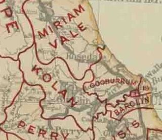
The Shire of Gooburrum was a local government area to the north and west of the regional city of Bundaberg, Australia. This area, administered from Bundaberg itself, covered an area of 1,312.6 square kilometres (506.8 sq mi), and existed as a local government entity from 1886 until 1994, when it amalgamated with Woongarra to form the Shire of Burnett.

The Shire of Woongarra was a local government area located to the south and east of the regional city of Bundaberg. The shire, administered from Bundaberg itself, covered an area of 722.4 square kilometres (278.9 sq mi), and existed as a local government entity from 1885 until 1994, when it amalgamated with Gooburrum to form the Shire of Burnett.

South Kolan Town in Queensland, Australia

South Kolan is a rural locality in the Bundaberg Region, Queensland, Australia. In the 2016 census, South Kolan had a population of 1,061 people.

Bundaberg North, Queensland Suburb of Bundaberg, Queensland, Australia

Bundaberg North is a suburb of Bundaberg in the Bundaberg Region, Queensland, Australia. In the 2016 census Bundaberg North had a population of 5,451 people. It occupies the developed area north of the Burnett River, opposite the Bundaberg CBD.

South Bingera is a rural residential locality in the Bundaberg Region, Queensland, Australia. In the 2016 census South Bingera had a population of 661 people.

Oakwood is a rural locality in the Bundaberg Region of the greater Wide Bay region of Queensland, Australia. In the 2016 census, Oakwood had a population of 331 people.

Sharon is a rural locality in the Bundaberg Region, Queensland, Australia. In the 2016 census, Sharon had a population of 1,316 people.

Coral Cove, Queensland Suburb of Bundaberg, Queensland, Australia

Coral Cove is a coastal locality in the Bundaberg Region, Queensland, Australia. In the 2016 census, Coral Cove had a population of 1,268 people. It has been used as a diving point by tourists and contains the Coral Cove Golf course.

Avondale is a rural town and locality in the Bundaberg Region, Queensland, Australia. In the 2016 census the locality of Avondale had a population of 643 people.

Yandaran, Queensland Town in Queensland, Australia

Yandaran is a rural town and locality in the Bundaberg Region, Queensland, Australia. In the 2016 census the locality of Yandaran had a population of 463 people.

Gooburrum is a rural locality in the Bundaberg Region, Queensland, Australia. In the 2016 census, Gooburrum had a population of 1,442 people. The neighbourhood of Tantitha is within the locality.

Elliott is a rural locality in the Bundaberg Region, Queensland, Australia. In the 2016 census, Elliott had a population of 138 people.

Bucca, Queensland Suburb of Bundaberg Region, Queensland, Australia

Bucca is a rural locality in the Bundaberg Region, Queensland, Australia. In the 2016 census, Bucca had a population of 1,027 people. The neighbourhood of Kolan is within the locality.

Pine Creek is a rural locality in the Bundaberg Region, Queensland, Australia. In the 2016 census Pine Creek had a population of 254 people.

Ashfield is a mixed residential and rural locality in the Bundaberg Region, Queensland, Australia. In the 2016 census, Ashfield had a population of 793 people.

References

  1. 1 2 3 Australian Bureau of Statistics (27 June 2017). "Welcome Creek (SSC)". 2016 Census QuickStats. Retrieved 20 October 2018. OOjs UI icon edit-ltr-progressive.svg
  2. "Welcome Creek – locality in Bundaberg Region (entry 44809)". Queensland Place Names. Queensland Government . Retrieved 26 December 2020.
  3. "Welcome Creek – watercourse in Bundaberg Regional (entry 36929)". Queensland Place Names. Queensland Government . Retrieved 6 March 2022.
  4. "North Gooburrum – locality unbounded in Bundaberg Regional (entry 40678)". Queensland Place Names. Queensland Government . Retrieved 6 March 2022.
  5. 1 2 3 4 "Queensland Globe". State of Queensland . Retrieved 23 April 2022.
  6. 1 2 3 Queensland Family History Society (2010), Queensland schools past and present (Version 1.01 ed.), Queensland Family History Society, ISBN   978-1-921171-26-0
  7. "Queensland state school - centre closures" (PDF). Queensland Government . 20 August 2013. Archived (PDF) from the original on 20 March 2022. Retrieved 7 April 2022.
  8. 1 2 "Bundaberg" (Map). Queensland Government. 1943. Archived from the original on 30 September 2020. Retrieved 23 April 2022.
  9. "9348-24 Bundaberg" (Map). Queensland Government. 1987. Archived from the original on 23 April 2022. Retrieved 23 April 2022.
  10. "9348-24 Bundaberg" (Map). Queensland Government. 2009. Archived from the original on 23 April 2022. Retrieved 23 April 2022.
  11. "Exclusive Brethren school closes at Welcome Creek". Bundaberg News Mail . 27 February 2014. Archived from the original on 28 January 2021. Retrieved 28 January 2021.
  12. "669 Moore Park Road, Welcome Creek QLD 4670". Commercial Real Estate. Archived from the original on 23 April 2022. Retrieved 23 April 2022.