Meadowvale, Queensland

Last updated

Meadowvale
Queensland
Australia Queensland location map.svg
Red pog.svg
Meadowvale
Coordinates 24°49′12″S152°14′20″E / 24.82°S 152.2388°E / -24.82; 152.2388 (Meadowvale (centre of locality))
Population434 (2021 census) [1]
 • Density8.577/km2 (22.21/sq mi)
Postcode(s) 4670
Area50.6 km2 (19.5 sq mi)
Time zone AEST (UTC+10:00)
Location
LGA(s) Bundaberg Region
State electorate(s) Burnett
Federal division(s) Flynn
Suburbs around Meadowvale:
Moorland Welcome Creek Welcome Creek
Bucca Meadowvale Gooburrum
South Kolan Sharon Oakwood

Meadowvale is a rural locality in the Bundaberg Region, Queensland, Australia. [2] In the 2021 census, Meadowvale had a population of 434 people. [1]

Contents

Geography

The locality is bounded to the south by Splitters Creek and to the north-east by the North Coast railway line. [3] [4]

The North Coast railway line enters the locality from the south-east (Oakwood / Gooburrum) and exits to the north (Moorland / Welcome Creek). Meadowvale railway station serves the locality ( 24°49′00″S152°16′32″E / 24.8166°S 152.2756°E / -24.8166; 152.2756 (Meadowvale railway station) ), [5] while Booloongie railway siding is now abandoned ( 24°49′40″S152°17′25″E / 24.82778°S 152.29028°E / -24.82778; 152.29028 (Booloongie railway siding (former)) ). [6] [7] [8]

The land use is predominantly crop growing (mostly sugarcane) with some grazing on native vegetation and rural residential housing. [9]

History

Booloongie railway siding was named in December 1918. [10] In October 1931, a collision occurred between a train and a truck at the level crossing. [11]

Meadowvale State School opened on 10 April 1934. [12] It was officially opened on Saturday 28 April 1934 by local politician Tommy Williams. [13] The school closed on 18 February 1945. [14] [15] It was on the northern side of Moorlands Road (approx 24°48′27″S152°15′15″E / 24.80739°S 152.25428°E / -24.80739; 152.25428 (Meadowvale State School (former)) ). [16]

Demographics

In the 2016 census, Meadowvale had a population of 469 people. [17]

In the 2021 census, Meadowvale had a population of 434 people. [1]

Education

There are no schools in Meadowvale. The nearest government primary schools are Gooburrum State School in neighbouring Gooburrum to the east and Sharon State School in neighbouring Sharon to the south. The nearest government secondary school is Bundaberg North State High School in Bundaberg North to the south-east. [18]

Amenities

The Bundaberg Pistol Club has its shooting range at 11 Heales Road ( 24°49′33″S152°15′54″E / 24.8258°S 152.2651°E / -24.8258; 152.2651 (Bundaberg Pistol Club) ). [19]

Attractions

Meadowvale Nature Park offers two walking tracks through paperbarks, eucalypts and grass trees to views over Splitters Creek. It is popular for its wildlfowers (seasonal), birdsong, and platypus sightings (dawn and dusk) in Splitters Creek. It is at 475 Rosedale Road ( 24°49′33″S152°16′13″E / 24.8257°S 152.2703°E / -24.8257; 152.2703 (Meadowvale Nature Park) ). [20] [21]

Despite the name, Bargara Berries have their strawberry farm at 104 Hoods Road ( 24°48′50″S152°17′16″E / 24.8138°S 152.2879°E / -24.8138; 152.2879 (Barbara Berries Meadowvale) ) in Meadowale. Visitors are welcome to visit the farm and pick their own berries. [22] [23]

Related Research Articles

<span class="mw-page-title-main">Bargara, Queensland</span> Town in Queensland, Australia

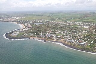
Bargara is a coastal town and suburb in the Bundaberg Region, Queensland, Australia. In the 2021 census, the suburb of Bargara had a population of 8,883 people.

<span class="mw-page-title-main">Burnett Heads, Queensland</span> Town in Queensland, Australia

Burnett Heads is a coastal town and locality in the Bundaberg Region, Queensland, Australia. In the 2021 census, the locality of Burnett Heads had a population of 2,908 people.

Innes Park is a coastal town and locality in the Bundaberg Region, Queensland, Australia. The town is 367 kilometres (228 mi) north of the state capital, Brisbane. In the 2021 census, the locality of Innes Park had a population of 2,653 people.

<span class="mw-page-title-main">Bundaberg Region</span> Local government area in Queensland, Australia

The Bundaberg Region is a local government area in the Wide Bay–Burnett region of Queensland, Australia, about 360 kilometres (220 mi) north of Brisbane, the state capital. It is centred on the city of Bundaberg, and also contains a significant rural area surrounding the city. It was created in 2008 from a merger of the City of Bundaberg with the Shires of Burnett, Isis and Kolan.

<span class="mw-page-title-main">Shire of Gooburrum</span> Local government area in Queensland, Australia

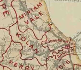
The Shire of Gooburrum was a local government area to the north and west of the regional city of Bundaberg, Australia. This area, administered from Bundaberg itself, covered an area of 1,312.6 square kilometres (506.8 sq mi), and existed as a local government entity from 1886 until 1994, when it amalgamated with Woongarra to form the Shire of Burnett.

<span class="mw-page-title-main">Curra, Queensland</span> Suburb of Gympie Region, Queensland, Australia

Curra is a rural residential locality in the Gympie Region, Queensland, Australia. In the 2021 census, Curra had a population of 2,104 people.

<span class="mw-page-title-main">South Kolan</span> Town in Queensland, Australia

South Kolan is a rural locality in the Bundaberg Region, Queensland, Australia. In the 2021 census, the locality of South Kolan had a population of 1,258 people.

<span class="mw-page-title-main">Oakwood, Queensland</span> Suburb of Bundaberg Region, Queensland, Australia

Oakwood is a rural locality in the Bundaberg Region, Queensland, Australia. In the 2021 census, Oakwood had a population of 364 people.

<span class="mw-page-title-main">Mon Repos, Queensland</span> Suburb of Bundaberg, Queensland, Australia

Mon Repos is a coastal locality in the Bundaberg Region, Queensland, Australia. In the 2021 census, Mon Repos had a population of 24 people.

<span class="mw-page-title-main">Bundaberg East</span> Suburb of Bundaberg, Queensland, Australia

Bundaberg East is a suburb of Bundaberg in the Bundaberg Region, Queensland, Australia. In the 2021 census, Bundaberg East had a population of 2,839 people.

Sharon is a rural locality in the Bundaberg Region, Queensland, Australia. In the 2021 census, Sharon had a population of 1,209 people.

<span class="mw-page-title-main">Alloway, Queensland</span> Suburb of Bundaberg Region, Queensland, Australia

Alloway is a rural locality in the Bundaberg Region, Queensland, Australia. In the 2021 census, Alloway had a population of 488 people.

Gooburrum is a rural locality in the Bundaberg Region, Queensland, Australia. In the 2021 census, Gooburrum had a population of 1,518 people. The neighbourhood of Tantitha is within the locality.

Kinkuna is a coastal locality in the Bundaberg Region, Queensland, Australia. In the 2021 census, Kinkuna had a population of 105 people.

Rubyanna is a rural locality in the Bundaberg Region, Queensland, Australia. In the 2021 census, Rubyanna had a population of 257 people.

Bungadoo is a rural locality in the Bundaberg Region, Queensland, Australia. The area was formerly known as Albionville. In the 2021 census, Bungadoo had a population of 342 people.

Avenell Heights is a southern suburb of Bundaberg in the Bundaberg Region, Queensland, Australia. In the 2021 census, Avenell Heights had a population of 5,028 people.

<span class="mw-page-title-main">Bucca, Queensland</span> Suburb of Bundaberg Region, Queensland, Australia

Bucca is a rural locality in the Bundaberg Region, Queensland, Australia. In the 2021 census, Bucca had a population of 1,063 people.

<span class="mw-page-title-main">Fairymead, Queensland</span> Suburb of Bundaberg Region, Queensland, Australia

Fairymead is a coastal locality in the Bundaberg Region, Queensland, Australia. In the 2021 census, Fairymead had a population of 28 people.

<span class="mw-page-title-main">Kensington, Queensland</span> Suburb of Bundaberg, Queensland, Australia

Kensington is a mixed-use locality in the Bundaberg Region, Queensland, Australia. Traditionally a rural area on the south-western outskirts of Bundaberg, there is increasing commercial and residential development within the locality. In the 2021 census, Kensington had a population of 722 people.

References

  1. 1 2 3 Australian Bureau of Statistics (28 June 2022). "Meadowvale (SAL)". 2021 Census QuickStats. Retrieved 28 February 2023. OOjs UI icon edit-ltr-progressive.svg
  2. "Meadowvale – locality in Bundaberg Region (entry 50102)". Queensland Place Names. Queensland Government . Retrieved 26 December 2020.
  3. "Layers: Locality; Mountains and ranges; Contours; Watercourses". Queensland Globe. Queensland Government. Archived from the original on 19 December 2017. Retrieved 12 September 2024.
  4. "Layers: Locality; Road and rail; Railways; Railway stations". Queensland Globe. Queensland Government. Archived from the original on 19 December 2017. Retrieved 12 September 2024.
  5. "Railway stations and sidings - Queensland". Queensland Open Data. Queensland Government. 2 October 2020. Archived from the original on 5 October 2020. Retrieved 5 October 2020.
  6. "Booloongie – railway station in the Bundaberg Region (entry 3668)". Queensland Place Names. Queensland Government . Retrieved 13 September 2024.
  7. "Queensland railways & tramways: passenger stations and stops" (PDF). The Branch Line Society. 20 July 2022. Archived (PDF) from the original on 13 September 2024. Retrieved 13 September 2024.
  8. "Queensland Two Mile series sheet 2m157" (Map). Queensland Government. 1942. Archived from the original on 13 September 2024. Retrieved 13 September 2024.
  9. "Layers: Locality; Protected areas and forests; Land use". Queensland Globe. Queensland Government. Archived from the original on 19 December 2017. Retrieved 12 September 2024.
  10. "Names of Railway Stations". The Brisbane Courier . No. 19, 011. Queensland, Australia. 23 December 1918. p. 6. Retrieved 13 September 2024 via National Library of Australia.
  11. "BUNDABERG ACCIDENT". Maryborough Chronicle, Wide Bay And Burnett Advertiser . No. 19, 015. Queensland, Australia. 3 October 1931. p. 8. Archived from the original on 13 September 2024. Retrieved 13 September 2024 via National Library of Australia.
  12. "GOVERNMENT TENDERS". The Telegraph . Queensland, Australia. 21 November 1933. p. 6 (CITY FINAL LAST MINUTE NEWS). Archived from the original on 13 September 2024. Retrieved 13 September 2024 via National Library of Australia.
  13. "PERSONAL". Maryborough Chronicle, Wide Bay And Burnett Advertiser . No. 19, 887. Queensland, Australia. 21 April 1934. p. 8. Archived from the original on 13 September 2024. Retrieved 13 September 2024 via National Library of Australia.
  14. Queensland Family History Society (2010), Queensland schools past and present (Version 1.01 ed.), Queensland Family History Society, ISBN   978-1-921171-26-0
  15. "Agency ID 11229, Meadowvale State School". Queensland State Archives . Retrieved 13 September 2024.
  16. "Bundaberg" (Map). Queensland Government. 1943. Archived from the original on 13 September 2024. Retrieved 13 September 2024.
  17. Australian Bureau of Statistics (27 June 2017). "Meadowvale (SSC)". 2016 Census QuickStats. Retrieved 20 October 2018. OOjs UI icon edit-ltr-progressive.svg
  18. "Layers: Locality; Schools and school catchments". Queensland Globe. Queensland Government. Archived from the original on 19 December 2017. Retrieved 12 September 2024.
  19. "Bundaberg Pistol Club Inc". bundabergpistol.org. Archived from the original on 13 September 2024. Retrieved 13 September 2024.
  20. "Meadowvale Nature Park". Tourism & Events Queensland. Queensland Government. Archived from the original on 13 September 2024. Retrieved 13 September 2024.
  21. "Explore our region: Meadowvale Environmental Reserve". Bundaberg Now. Archived from the original on 13 September 2024. Retrieved 13 September 2024.
  22. "Bargara Berries". Tourism & Events Queensland. Queensland Government. Archived from the original on 13 September 2024. Retrieved 12 September 2024.
  23. "Bargara Berries Meadowvale". Facebook . Archived from the original on 13 September 2024. Retrieved 12 September 2024.