
Childers is a rural town and locality in the Bundaberg Region, Queensland, Australia. In the 2021 census, the locality of Childers had a population of 1,682 people.

Mount Perry is a rural town and locality in the North Burnett Region, Queensland, Australia. In the 2021 census, the locality of Mount Perry had a population of 487 people.
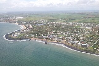
Bargara is a coastal town and suburb in the Bundaberg Region, Queensland, Australia. In the 2021 census, the suburb of Bargara had a population of 8,883 people.

Burnett Heads is a coastal town and locality in the Bundaberg Region, Queensland, Australia. In the 2021 census, the locality of Burnett Heads had a population of 2,908 people.

Goomeri is a rural town and locality in the Gympie Region, Queensland, Australia. In the 2021 census, the locality of Goomeri had a population of 677 people.

Howard is a rural town and locality in the Fraser Coast Region, Queensland, Australia. It is a southern boundary of the Dundaburra peoples of the Northern Kabi Kabi Isis districts and surrounds. It is located 284 kilometres (176 mi) north of Brisbane and 37 kilometres (23 mi) west of Hervey Bay. In the 2021 census, the locality of Howard had a population of 1,394 people.

Moore Park Beach is a coastal rural locality in the Bundaberg Region, Queensland, Australia. The coastal town of Moore Park is within the locality.

Theebine is a rural town and locality split between the Gympie Region and the Fraser Coast Region, both in Queensland, Australia.

Bundaberg Central is the central suburb and central business district of Bundaberg in the Bundaberg Region, Queensland, Australia. In the 2021 census, Bundaberg Central had a population of 162 people.

South Kolan is a rural locality in the Bundaberg Region, Queensland, Australia. In the 2021 census, the locality of South Kolan had a population of 1,258 people.

Bundaberg North is a suburb of Bundaberg in the Bundaberg Region, Queensland, Australia. It occupies the developed area north of the Burnett River, opposite the Bundaberg CBD. In the 2021 census, Bundaberg North had a population of 5,563 people.

Torbanlea is a rural town and locality in the Fraser Coast Region, Queensland, Australia. In the 2021 census, the locality of Torbanlea had a population of 841 people.

Oakwood is a rural locality in the Bundaberg Region, Queensland, Australia. In the 2021 census, Oakwood had a population of 364 people.

Bundaberg East is a suburb of Bundaberg in the Bundaberg Region, Queensland, Australia. In the 2021 census, Bundaberg East had a population of 2,839 people.
Kalkie is a suburb of Bundaberg in the Bundaberg Region, Queensland, Australia. In the 2021 census, Kalkie had a population of 2,968 people.
Gooburrum is a rural locality in the Bundaberg Region, Queensland, Australia. In the 2021 census, Gooburrum had a population of 1,518 people. The neighbourhood of Tantitha is within the locality.

Dallarnil is a rural town and locality in the North Burnett Region, Queensland, Australia. In the 2021 census, the locality of Dallarnil had a population of 245 people.
Bungadoo is a rural locality in the Bundaberg Region, Queensland, Australia. The area was formerly known as Albionville. In the 2021 census, Bungadoo had a population of 342 people.
Good Night is a rural locality split between the Bundaberg Region and the North Burnett Region, Queensland, Australia. It is also written as Goodnight. In the 2021 census, Good Night had a population of 151 people.
Morganville is a rural locality in the Bundaberg Region, Queensland, Australia.


