McIlwraith, Queensland

Last updated

McIlwraith
Queensland
Australia Queensland location map.svg
Red pog.svg
McIlwraith
Coordinates 25°S152°E / 25°S 152°E / -25; 152 Coordinates: 25°S152°E / 25°S 152°E / -25; 152
Population191 (2016 census) [1]
 • Density8.27/km2 (21.42/sq mi)
Postcode(s) 4671
Area23.1 km2 (8.9 sq mi)
Time zone AEST (UTC+10:00)
LGA(s) Bundaberg Region
State electorate(s) Callide
Federal Division(s) Flynn
Suburbs around McIlwraith:
Gin Gin Maroondan Maroondan
Redhill Farms McIlwraith Delan
Skyring Reserve Drinan Delan

McIlwraith is a rural locality in the Bundaberg Region, Queensland, Australia. [2] In the 2016 census, McIlwraith had a population of 191 people. [1]

Contents

History

The locality was named after the former railway station, which in turn was named after former Premier of Queensland Thomas McIlwraith. [2]

McIlwraith State School opened on 30 October 1934. [3]

In the 2011 census McIlwraith had a population of 327. [4]

In the 2016 census, McIlwraith had a population of 191 people. [1]

Education

McIlwraith State School is a government primary (Prep-6) school for boys and girls at 322 McIlwraith Road ( 25°00′31″S151°59′57″E / 25.0085°S 151.9993°E / -25.0085; 151.9993 (McIlwraith State School) ). [5] [6] In 2017, the school had an enrolment of 21 students with 2 teachers and 5 non-teaching staff (2 full-time equivalent). [7]

There is no secondary school in McIlwraith; the nearest secondary school in neighbouring Gin Gin. [8]

Related Research Articles

Gin Gin, Queensland Town in Queensland, Australia

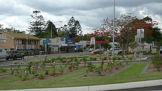
Gin Gin is a rural town and locality in the Bundaberg Region, Queensland, Australia. In the 2016 census, Gin Gin had a population of 1,053 people.

Miriam Vale Town in Queensland, Australia

Miriam Vale is a rural town and a locality in the Gladstone Region, Queensland, Australia. In the 2016 census, Miriam Vale had a population of 512 people.

Mount Perry, Queensland Town in Queensland, Australia

Mount Perry is a small town and locality in the North Burnett Region in southeastern Queensland, Australia. In the 2016 census, Mount Perry had a population of 538 people. The neighbourhood of Drummers Creek is in the locality.

Monto, Queensland Town in Queensland, Australia

Monto is a rural town and locality in the North Burnett Region, Queensland, Australia. In the 2016 census, Monto had a population of 1,189 people.

Shire of Kolan Local government area in Queensland, Australia

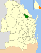
The Shire of Kolan was a local government area located in the Wide Bay–Burnett region of Queensland, Australia, to the west of Bundaberg. The Shire, administered from the town of Gin Gin, covered an area of 2,650.6 square kilometres (1,023.4 sq mi), and existed as a local government entity from 1879 until 2008, when it was amalgamated with the City of Bundaberg and the Shires of Burnett and Isis to form the Bundaberg Region.

Wallaville Town in Queensland, Australia

Wallaville is a rural town and locality in the Bundaberg Region, Queensland, Australia. It is 372 kilometres (231 mi) north of the state capital, Brisbane and 43 kilometres (27 mi) south west of the regional centre of Bundaberg. In the 2016 census, Wallaville had a population of 410 people.

Bullyard Town in Queensland, Australia

Bullyard is a small rural town and locality in Bundaberg Region, Queensland, Australia. In 2016 census Bullyard had a population of 189 people.

South Kolan Town in Queensland, Australia

South Kolan is a rural locality in the Bundaberg Region, Queensland, Australia. In the 2016 census, South Kolan had a population of 1,061 people.

Avoca, Queensland Suburb of Bundaberg, Queensland, Australia

Avoca is a suburb of Bundaberg in the Bundaberg Region, Queensland, Australia. In the 2016 census, Avoca had a population of 4,904 people.

Sharon, Queensland Suburb of Bundaberg Region, Queensland, Australia

Sharon is a locality in the Bundaberg Region, Queensland, Australia. In the 2016 census Sharon had a population of 1,316 people.

Booyal, Queensland Town in Queensland, Australia

Booyal is a town and a locality in the Bundaberg Region, Queensland, Australia. In the 2016 census, Booyal had a population of 275 people.

Gooburrum, Queensland Suburb of Bundaberg Region, Queensland, Australia

Gooburrum is a rural locality in the Bundaberg Region, Queensland, Australia. In the 2016 census, Gooburrum had a population of 1,442 people. The neighbourhood of Tantitha is within the locality.

Bucca, Queensland Suburb of Bundaberg Region, Queensland, Australia

Bucca is a rural locality in the Bundaberg Region, Queensland, Australia. In the 2016 census, Bucca had a population of 1,027 people. The neighbourhood of Kolan is within the locality.

Damascus, Queensland Suburb of Bundaberg Region, Queensland, Australia

Damascus is a locality in the Bundaberg Region, Queensland, Australia. In the 2016 census, Damascus had a population of 97 people.

Monduran, Queensland Suburb of Bundaberg Region, Queensland, Australia

Monduran is a rural locality in the Bundaberg Region, Queensland, Australia. In the 2016 census, Monduran had a population of 91 people.

Duingal, Queensland Suburb of Bundaberg Region, Queensland, Australia

Duingal is a locality in the Bundaberg Region, Queensland, Australia. In the 2016 census, Duingal had a population of 77 people.

Dalga, Queensland Suburb of Bundaberg Region, Queensland, Australia

Dalga is a locality in the Bundaberg Region, Queensland, Australia. In the 2016 census, Dalga had a population of 3 people.

Molangul, Queensland Suburb of Bundaberg Region, Queensland, Australia

Molangul is a rural locality in the Bundaberg Region, Queensland, Australia. In the 2016 census, Molangul had a population of 13 people.

Kolonga, Queensland Suburb of Bundaberg Region, Queensland, Australia

Kolonga is a rural locality in the Bundaberg Region, Queensland, Australia. In the 2016 census, Kolonga had a population of 49 people.

Wonbah, Queensland Suburb of Bundaberg Region, Queensland, Australia

Wonbah is a rural locality in the Bundaberg Region, Queensland, Australia. In the 2016 census, Wonbah had a population of 98 people.

References

  1. 1 2 3 Australian Bureau of Statistics (27 June 2017). "McIlwraith (SSC)". 2016 Census QuickStats. Retrieved 20 October 2018. OOjs UI icon edit-ltr-progressive.svg
  2. 1 2 "McIlwraith - locality in Bundaberg Region (entry 44741)". Queensland Place Names. Queensland Government . Retrieved 26 January 2020.
  3. Queensland Family History Society (2010), Queensland schools past and present (Version 1.01 ed.), Queensland Family History Society, ISBN   978-1-921171-26-0
  4. Australian Bureau of Statistics (31 October 2012). "McIlwraith (State Suburb)". 2011 Census QuickStats. Retrieved 3 February 2014. OOjs UI icon edit-ltr-progressive.svg
  5. "State and non-state school details". Queensland Government. 9 July 2018. Archived from the original on 21 November 2018. Retrieved 21 November 2018.
  6. "McIlwraith State School" . Retrieved 21 November 2018.
  7. "ACARA School Profile 2017". Archived from the original on 22 November 2018. Retrieved 22 November 2018.
  8. "Queensland Globe". State of Queensland . Retrieved 29 February 2020.